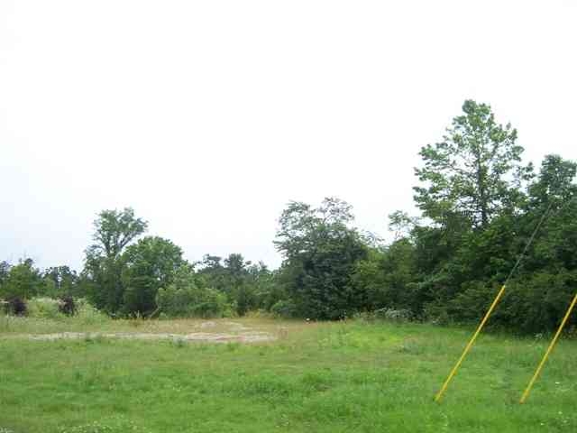
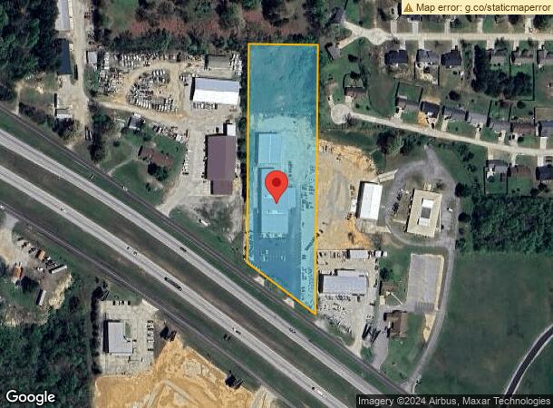
Property Record
4250 Highway 67 N, Poplar Bluff, MO 63901
NEARBY LISTINGS FOR SALE OR LEASE
Property Detail
4250 Highway 67 N
109-08-04-19-0-002-000-023-000
E 13 E12 S12 LOT 2 NW14 N HWY
Storebuilding
Butler
X
Missouri
29023C0190E
2
2023
4.60 AC
2023
Missouri South Area
950101
Other Market Areas
19,308 SF
Poplar Bluff, MO
DEMOGRAPHICS near 4250 Highway 67 N
1 Mile
3 Mile
5 Mile
2024 Total Population
1,235
13,913
26,139
2029 Population
1,223
13,801
26,073
Pop Growth 2024-2029
(0.97%)
(0.81%)
(0.25%)
Average Age
40
40
40
2024 Total Households
459
5,490
10,611
HH Growth 2024-2029
(1.31%)
(0.87%)
(0.25%)
Median Household Inc
$54,354
$47,625
$43,643
Avg Household Size
2.30
2.40
2.40
2024 Avg HH Vehicles
2.00
2.00
2.00
Median Home Value
$164,515
$151,357
$131,689
Median Year Built
1982
1982
1979
Nearby Places
- Restaurants
- Banks
- Shops
- Fitness
- Groceries
PUBLIC TRANSPORTATION
COMMUTER RAIL
Poplar Bluff Amtrak Station (Texas Eagle - Amtrak)
Drive
Walk
Distance
Poplar Bluff Amtrak Station (Texas Eagle - Amtrak)
10 min
5.6 mi
Freight Ports
Tulsa Port of Inola
Drive
Walk
Distance
Tulsa Port of Inola
399 min
351.8 mi
Nearby Properties
Address
Land Use
TOTAL SIZE
Lot Size
Zoning
Address
Land Use
TOTAL SIZE
Lot Size
Zoning
72,348 SF
7.13 AC
Address
Land Use
TOTAL SIZE
Lot Size
Zoning
98,595 SF
72.86 AC
Address
Land Use
TOTAL SIZE
Lot Size
Zoning
69,606 SF
10 AC
Address
Land Use
TOTAL SIZE
Lot Size
Zoning
6,068 SF
17.73 AC
Address
Land Use
TOTAL SIZE
Lot Size
Zoning
31,780 SF
4.07 AC
Address
Land Use
TOTAL SIZE
Lot Size
Zoning
176,910 SF
17.10 AC
Address
Land Use
TOTAL SIZE
Lot Size
Zoning
11,688 SF
22.30 AC
Address
Land Use
TOTAL SIZE
Lot Size
Zoning
27,670 SF
4.03 AC
Address
Land Use
TOTAL SIZE
Lot Size
Zoning
41,250 SF
62.62 AC
Address
Land Use
TOTAL SIZE
Lot Size
Zoning
35,150 SF
4.66 AC
Address
Land Use
TOTAL SIZE
Lot Size
Zoning
16,900 SF
4.32 AC
Address
Land Use
TOTAL SIZE
Lot Size
Zoning
63,512 SF
4.58 AC
Address
Land Use
TOTAL SIZE
Lot Size
Zoning
67,368 SF
5.29 AC
Address
Land Use
TOTAL SIZE
Lot Size
Zoning
19,212 SF
2.70 AC
Address
Land Use
TOTAL SIZE
Lot Size
Zoning
18,108 SF
Address
Land Use
TOTAL SIZE
Lot Size
Zoning
28,144 SF
3.74 AC
Address
Land Use
TOTAL SIZE
Lot Size
Zoning
42,799 SF
11.12 AC
Address
Land Use
TOTAL SIZE
Lot Size
Zoning
27,325 SF
24.69 AC
Address
Land Use
TOTAL SIZE
Lot Size
Zoning
19,129 SF
14.40 AC
Address
Land Use
TOTAL SIZE
Lot Size
Zoning
41,347 SF
1.61 AC
Address
Land Use
TOTAL SIZE
Lot Size
Zoning
12,181 SF
3.45 AC
Address
Land Use
TOTAL SIZE
Lot Size
Zoning
5,052 SF
2.78 AC
Address
Land Use
TOTAL SIZE
Lot Size
Zoning
11,712 SF
1.48 AC
Address
Land Use
TOTAL SIZE
Lot Size
Zoning
87,109 SF
11.40 AC
Address
Land Use
TOTAL SIZE
Lot Size
Zoning
16,409 SF
14.97 AC
Address
Land Use
TOTAL SIZE
Lot Size
Zoning
42,262 SF
3.94 AC
Address
Land Use
TOTAL SIZE
Lot Size
Zoning
15,657 SF
5.21 AC
Address
Land Use
TOTAL SIZE
Lot Size
Zoning
102,001 SF
5.74 AC
Address
Land Use
TOTAL SIZE
Lot Size
Zoning
33,806 SF
5.48 AC
Address
Land Use
TOTAL SIZE
Lot Size
Zoning
11,190 SF
6.22 AC
Start a new search to find other properties for sale or lease
Connect with us
© 2024 CoStar Group
The information above has been obtained from sources believed reliable. While we do not doubt its accuracy we have not verified it and make no guarantee, warranty or representation about it. It is your responsibility to independently confirm its accuracy and completeness. Any projections, opinions, assumptions, or estimates used are for example only and do not represent the current or future performance of the property. The value of this transaction to you depends on tax and other factors which should be evaluated by your tax, financial, and legal advisors. You and your advisors should conduct a careful, independent investigation of the property to determine to your satisfaction the suitability of the property for your needs.