Property Record
4251 Saron Dr, Lexington, KY 40515
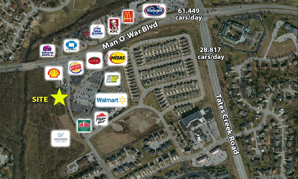
NEARBY LISTINGS FOR SALE OR LEASE
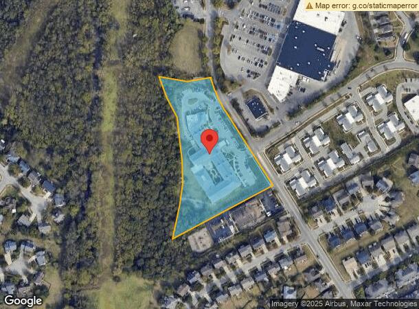
Property Detail
4251 Saron Dr
Lexington-Fayette, KY
Coons Property
19978480
K-306 COONS PROPERTY UNIT 10 LOT 1; BOOK: 3302 PAGE: 435
Retirementnursinghomecombined
Fayette
X
Kentucky
2100670209F
1
2024
4.24 AC
2024
East Lexington/Fayette
004107
Lexington/Fayette
82,436 SF
DEMOGRAPHICS near 4251 Saron Dr
1 Mile
3 Mile
5 Mile
2024 Total Population
18,884
85,426
174,180
2029 Population
18,764
85,083
173,750
Pop Growth 2024-2029
(0.64%)
(0.40%)
(0.25%)
Average Age
38
39
38
2024 Total Households
8,216
37,329
74,335
HH Growth 2024-2029
(0.67%)
(0.44%)
(0.29%)
Median Household Inc
$68,264
$62,018
$63,446
Avg Household Size
2.20
2.20
2.20
2024 Avg HH Vehicles
2.00
2.00
2.00
Median Home Value
$245,380
$244,195
$263,530
Median Year Built
1991
1983
1981
Nearby Places
- Restaurants
- Banks
- Shops
- Fitness
- Groceries
PUBLIC TRANSPORTATION
AIRPORT
Blue Grass
DRIVE
WALK
Distance
Blue Grass
20 min
11.3 mi
Freight Ports
Port of Toledo
DRIVE
WALK
Distance
Port of Toledo
345 min
293.7 mi
SALE & LEASE HISTORY
LISTING DATE
SALE/LEASE

Sep 24, 2016
For Sale
Nearby Properties
Address
Land Use
TOTAL SIZE
Lot Size
Zoning
Address
Land Use
TOTAL SIZE
Lot Size
Zoning
76,441 SF
63.86 AC
A-U
Address
Land Use
TOTAL SIZE
Lot Size
Zoning
318,370 SF
17.79 AC
B-6P
Address
Land Use
TOTAL SIZE
Lot Size
Zoning
4,299 SF
18.43 AC
R-4
Address
Land Use
TOTAL SIZE
Lot Size
Zoning
8,001 SF
32.59 AC
MU-3
Address
Land Use
TOTAL SIZE
Lot Size
Zoning
144,866 SF
14.83 AC
B-6P
Address
Land Use
TOTAL SIZE
Lot Size
Zoning
238,393 SF
9.83 AC
B-6P
Address
Land Use
TOTAL SIZE
Lot Size
Zoning
22.10 AC
R-3
Address
Land Use
TOTAL SIZE
Lot Size
Zoning
5,650 SF
22.46 AC
R-3
Address
Land Use
TOTAL SIZE
Lot Size
Zoning
12,767 SF
14.39 AC
R-3
Address
Land Use
TOTAL SIZE
Lot Size
Zoning
137,905 SF
23.79 AC
B-6P
Address
Land Use
TOTAL SIZE
Lot Size
Zoning
184,756 SF
4.43 AC
MU-3
Address
Land Use
TOTAL SIZE
Lot Size
Zoning
91,484 SF
14.72 AC
B-6P
Address
Land Use
TOTAL SIZE
Lot Size
Zoning
7,402 SF
18.83 AC
R-4
Address
Land Use
TOTAL SIZE
Lot Size
Zoning
4,859 SF
20.45 AC
R-3
Address
Land Use
TOTAL SIZE
Lot Size
Zoning
6.25 AC
A-U
Address
Land Use
TOTAL SIZE
Lot Size
Zoning
41,040 SF
14.77 AC
R-4
Address
Land Use
TOTAL SIZE
Lot Size
Zoning
28,776 SF
13.82 AC
B-1
Address
Land Use
TOTAL SIZE
Lot Size
Zoning
2,316 SF
15.05 AC
R-4
Address
Land Use
TOTAL SIZE
Lot Size
Zoning
222,168 SF
26.49 AC
B-6P
Address
Land Use
TOTAL SIZE
Lot Size
Zoning
160,800 SF
74.22 AC
R-1C
Address
Land Use
TOTAL SIZE
Lot Size
Zoning
14,928 SF
8.75 AC
R-3
Address
Land Use
TOTAL SIZE
Lot Size
Zoning
4,406 SF
28.12 AC
R-3
Address
Land Use
TOTAL SIZE
Lot Size
Zoning
156,350 SF
18.83 AC
B-6P
Address
Land Use
TOTAL SIZE
Lot Size
Zoning
178,160 SF
14.62 AC
R-3
Address
Land Use
TOTAL SIZE
Lot Size
Zoning
4,992 SF
32.12 AC
Address
Land Use
TOTAL SIZE
Lot Size
Zoning
93,675 SF
10.32 AC
A-U
Address
Land Use
TOTAL SIZE
Lot Size
Zoning
9,186 SF
12 AC
R-3
Address
Land Use
TOTAL SIZE
Lot Size
Zoning
4,452 SF
20.28 AC
R-4
Address
Land Use
TOTAL SIZE
Lot Size
Zoning
88,276 SF
10.97 AC
A-U
Address
Land Use
TOTAL SIZE
Lot Size
Zoning
219,320 SF
8.35 AC
R-4
The World's #1 Commercial Real Estate Marketplace
Connect with us
© 2025 CoStar Group
The information above has been obtained from sources believed reliable. While we do not doubt its accuracy we have not verified it and make no guarantee, warranty or representation about it. It is your responsibility to independently confirm its accuracy and completeness. Any projections, opinions, assumptions, or estimates used are for example only and do not represent the current or future performance of the property. The value of this transaction to you depends on tax and other factors which should be evaluated by your tax, financial, and legal advisors. You and your advisors should conduct a careful, independent investigation of the property to determine to your satisfaction the suitability of the property for your needs.