Property Record
4275 Durham Rd, Roxboro, NC 27574
NEARBY LISTINGS FOR SALE OR LEASE
-
-
View all Roxboro listings for sale on LoopNet.com
Property Detail
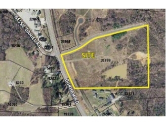
4275 Durham Rd
A51-176
Plat Of Survey Boyette Automotive Proper
Storebuilding
24 ACRES/TWINS RETAIL STORE
X
Person
3720090300K
North Carolina
2024
24 AC
2024
Person County
920300
Raleigh/Durham
9,756 SF
Durham-Chapel Hill, NC
DEMOGRAPHICS near 4275 Durham Rd
1 Mile
3 Mile
5 Mile
2024 Total Population
385
4,934
16,076
2029 Population
396
5,055
16,513
Pop Growth 2024-2029
+ 2.86%
+ 2.45%
+ 2.72%
Average Age
41
42
42
2024 Total Households
163
2,032
6,710
HH Growth 2024-2029
+ 3.07%
+ 2.46%
+ 2.68%
Median Household Inc
$36,389
$45,533
$47,016
Avg Household Size
2.30
2.40
2.30
2024 Avg HH Vehicles
2.00
2.00
2.00
Median Home Value
$103,448
$142,050
$158,912
Median Year Built
1985
1989
1984
Nearby Places
- Restaurants
- Banks
- Shops
- Fitness
- Groceries
SALE & LEASE HISTORY
LISTING DATE
SALE/LEASE

Sep 24, 2016
For Sale
Nearby Properties
Address
Land Use
TOTAL SIZE
Lot Size
Zoning
Address
Land Use
TOTAL SIZE
Lot Size
Zoning
200,964 SF
42.79 AC
Address
Land Use
TOTAL SIZE
Lot Size
Zoning
54,132 SF
42.03 AC
Address
Land Use
TOTAL SIZE
Lot Size
Zoning
112,896 SF
8.82 AC
Address
Land Use
TOTAL SIZE
Lot Size
Zoning
23,040 SF
173 AC
Address
Land Use
TOTAL SIZE
Lot Size
Zoning
153,823 SF
19.76 AC
Address
Land Use
TOTAL SIZE
Lot Size
Zoning
126,000 SF
32.71 AC
Address
Land Use
TOTAL SIZE
Lot Size
Zoning
71,339 SF
6.65 AC
RC
Address
Land Use
TOTAL SIZE
Lot Size
Zoning
70,797 SF
34.92 AC
Address
Land Use
TOTAL SIZE
Lot Size
Zoning
968 SF
10 AC
Address
Land Use
TOTAL SIZE
Lot Size
Zoning
62,596 SF
40 AC
Address
Land Use
TOTAL SIZE
Lot Size
Zoning
86,968 SF
11.53 AC
Address
Land Use
TOTAL SIZE
Lot Size
Zoning
190,795 SF
30 AC
Address
Land Use
TOTAL SIZE
Lot Size
Zoning
63,360 SF
1.26 AC
Address
Land Use
TOTAL SIZE
Lot Size
Zoning
22,292 SF
2.76 AC
Address
Land Use
TOTAL SIZE
Lot Size
Zoning
9,464 SF
0.42 AC
Address
Land Use
TOTAL SIZE
Lot Size
Zoning
15,460 SF
3.36 AC
Address
Land Use
TOTAL SIZE
Lot Size
Zoning
3,596 SF
14.89 AC
Address
Land Use
TOTAL SIZE
Lot Size
Zoning
11,660 SF
3 AC
Address
Land Use
TOTAL SIZE
Lot Size
Zoning
23,813 SF
0.42 AC
Address
Land Use
TOTAL SIZE
Lot Size
Zoning
18,556 SF
2.59 AC
Address
Land Use
TOTAL SIZE
Lot Size
Zoning
41,229 SF
1.79 AC
Address
Land Use
TOTAL SIZE
Lot Size
Zoning
40,784 SF
0.96 AC
Address
Land Use
TOTAL SIZE
Lot Size
Zoning
32,728 SF
2.71 AC
Address
Land Use
TOTAL SIZE
Lot Size
Zoning
42,733 SF
3.44 AC
Address
Land Use
TOTAL SIZE
Lot Size
Zoning
21,120 SF
2.10 AC
Address
Land Use
TOTAL SIZE
Lot Size
Zoning
5,157 SF
10 AC
Address
Land Use
TOTAL SIZE
Lot Size
Zoning
7,305 SF
4.41 AC
Address
Land Use
TOTAL SIZE
Lot Size
Zoning
13,043 SF
4 AC
Address
Land Use
TOTAL SIZE
Lot Size
Zoning
33,011 SF
20.85 AC
Address
Land Use
TOTAL SIZE
Lot Size
Zoning
18,550 SF
1.32 AC
The World's #1 Commercial Real Estate Marketplace
Connect with us
© 2025 CoStar Group
The information above has been obtained from sources believed reliable. While we do not doubt its accuracy we have not verified it and make no guarantee, warranty or representation about it. It is your responsibility to independently confirm its accuracy and completeness. Any projections, opinions, assumptions, or estimates used are for example only and do not represent the current or future performance of the property. The value of this transaction to you depends on tax and other factors which should be evaluated by your tax, financial, and legal advisors. You and your advisors should conduct a careful, independent investigation of the property to determine to your satisfaction the suitability of the property for your needs.