Property Record
4293 Lambert Dr, Howell, MI 48855
NEARBY LISTINGS FOR SALE OR LEASE
-
-
View all Howell listings for sale on LoopNet.com
Property Detail
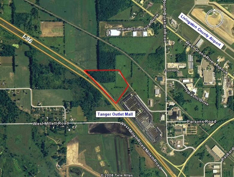
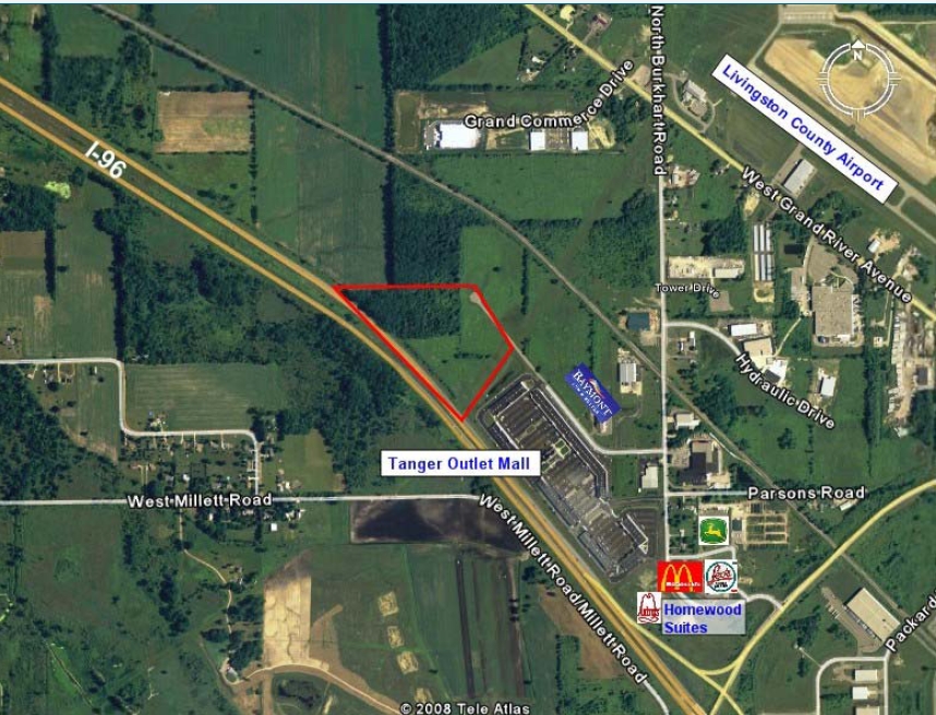
4293 Lambert Dr
06-29-200-032
SEC 29 T3NR4E COM E 1/4 COR OF SEC TH ALG C/L OF BURKHART RD N00*54'50"W 393.77 FT TH ALG THE SLY & SWLY LINE OF LAMBERT DR A
Commercialacreage
Livingston
X
Michigan
26093C0169D
13.92 AC
2024
Livingston County
2024
Detroit
724003
Detroit-Warren-Dearborn, MI
DEMOGRAPHICS near 4293 Lambert Dr
1 Mile
3 Mile
5 Mile
2024 Total Population
742
7,778
34,382
2029 Population
749
7,962
35,308
Pop Growth 2024-2029
+ 0.94%
+ 2.37%
+ 2.69%
Average Age
43
42
41
2024 Total Households
298
2,959
13,667
HH Growth 2024-2029
+ 0.67%
+ 2.23%
+ 2.69%
Median Household Inc
$69,244
$83,024
$75,340
Avg Household Size
2.40
2.50
2.40
2024 Avg HH Vehicles
2.00
2.00
2.00
Median Home Value
$189,873
$249,498
$243,445
Median Year Built
1997
1993
1989
Nearby Places
- Restaurants
- Banks
- Shops
- Fitness
- Groceries
PUBLIC TRANSPORTATION
AIRPORT
Bishop International
DRIVE
WALK
Distance
Bishop International
59 min
31.4 mi
Freight Ports
Port of Toledo
DRIVE
WALK
Distance
Port of Toledo
121 min
93.3 mi
SALE & LEASE HISTORY
LISTING DATE
SALE/LEASE

Sep 24, 2016
For Sale
Nearby Properties
Address
Land Use
TOTAL SIZE
Lot Size
Zoning
Address
Land Use
TOTAL SIZE
Lot Size
Zoning
43,959 SF
33.51 AC
IFZ
Address
Land Use
TOTAL SIZE
Lot Size
Zoning
75,407 SF
159.26 AC
R2
Address
Land Use
TOTAL SIZE
Lot Size
Zoning
40,005 SF
4.87 AC
RM
Address
Land Use
TOTAL SIZE
Lot Size
Zoning
40,005 SF
3.30 AC
RM
Address
Land Use
TOTAL SIZE
Lot Size
Zoning
40,005 SF
2.74 AC
RM
Address
Land Use
TOTAL SIZE
Lot Size
Zoning
46,843 SF
3.81 AC
RM
Address
Land Use
TOTAL SIZE
Lot Size
Zoning
55,626 SF
MXD
Address
Land Use
TOTAL SIZE
Lot Size
Zoning
35,132 SF
1.90 AC
RM
Address
Land Use
TOTAL SIZE
Lot Size
Zoning
11,067 SF
1.01 AC
MXD
Address
Land Use
TOTAL SIZE
Lot Size
Zoning
20,513 SF
2.36 AC
MXD
Address
Land Use
TOTAL SIZE
Lot Size
Zoning
17,769 SF
1.76 AC
MXD
Address
Land Use
TOTAL SIZE
Lot Size
Zoning
4,382 SF
0.90 AC
MXD
Address
Land Use
TOTAL SIZE
Lot Size
Zoning
48.61 AC
OS
Address
Land Use
TOTAL SIZE
Lot Size
Zoning
23,421 SF
1.53 AC
RM
Address
Land Use
TOTAL SIZE
Lot Size
Zoning
23,421 SF
3.24 AC
RM
Address
Land Use
TOTAL SIZE
Lot Size
Zoning
4.40 AC
MXD
Address
Land Use
TOTAL SIZE
Lot Size
Zoning
1,620 SF
162.19 AC
SFR
Address
Land Use
TOTAL SIZE
Lot Size
Zoning
6,248 SF
6.10 AC
AGRIG/R
Address
Land Use
TOTAL SIZE
Lot Size
Zoning
Address
Land Use
TOTAL SIZE
Lot Size
Zoning
1,275 SF
12.62 AC
LIGHT I
Address
Land Use
TOTAL SIZE
Lot Size
Zoning
30.44 AC
IFZ
Address
Land Use
TOTAL SIZE
Lot Size
Zoning
38 AC
NSC
Address
Land Use
TOTAL SIZE
Lot Size
Zoning
19.26 AC
OS
Address
Land Use
TOTAL SIZE
Lot Size
Zoning
223 AC
AR
Address
Land Use
TOTAL SIZE
Lot Size
Zoning
139.35 AC
R2
Address
Land Use
TOTAL SIZE
Lot Size
Zoning
6.87 AC
SFR
Address
Land Use
TOTAL SIZE
Lot Size
Zoning
2,351 SF
0.85 AC
MXD
Address
Land Use
TOTAL SIZE
Lot Size
Zoning
2,306 SF
180.81 AC
AR
Address
Land Use
TOTAL SIZE
Lot Size
Zoning
22,392 SF
10.02 AC
AR
The World's #1 Commercial Real Estate Marketplace
Connect with us
© 2025 CoStar Group
The information above has been obtained from sources believed reliable. While we do not doubt its accuracy we have not verified it and make no guarantee, warranty or representation about it. It is your responsibility to independently confirm its accuracy and completeness. Any projections, opinions, assumptions, or estimates used are for example only and do not represent the current or future performance of the property. The value of this transaction to you depends on tax and other factors which should be evaluated by your tax, financial, and legal advisors. You and your advisors should conduct a careful, independent investigation of the property to determine to your satisfaction the suitability of the property for your needs.