Property Record
4312 Shady Oak Rd S, Hopkins, MN 55343
NEARBY LISTINGS FOR SALE OR LEASE
Property Detail
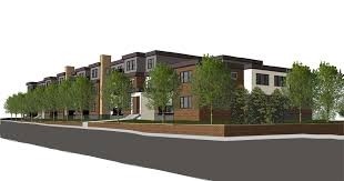
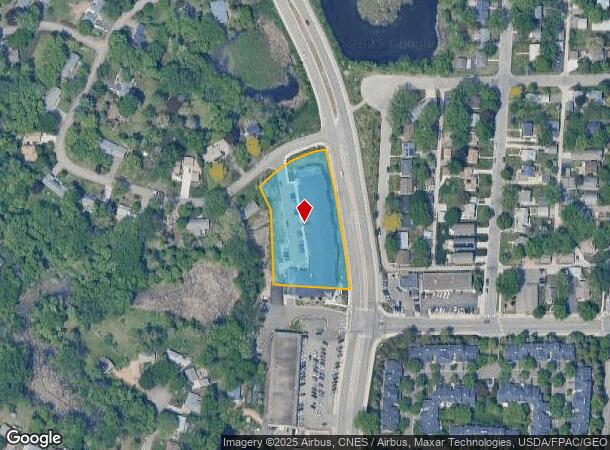
4312 Shady Oak Rd S
Minneapolis/St Paul
Shady Oak Crossing
Minneapolis-St. Paul-Bloomington, MN-WI
BLOCK 001 T SHADY OAK CROSSING LOT 1, EXCEPT THE PART WHICH LIES 200 FEET SOUTH OF THE SOUTH LINE OF LOT 20, OAKRIDGE ADDITION. IRREGULAR
23-117-22-42-0063
Hennepin
Apartment
Minnesota
2024
1
2023
1.58 AC
0261031003
East Minnetonka
DEMOGRAPHICS near 4312 Shady Oak Rd S
1 Mile
3 Mile
5 Mile
2024 Total Population
9,389
71,114
186,909
2029 Population
9,265
70,164
184,213
Pop Growth 2024-2029
(1.32%)
(1.34%)
(1.44%)
Average Age
42
42
42
2024 Total Households
4,136
32,110
81,503
HH Growth 2024-2029
(1.50%)
(1.46%)
(1.49%)
Median Household Inc
$81,331
$88,190
$102,039
Avg Household Size
2.20
2.10
2.20
2024 Avg HH Vehicles
2.00
2.00
2.00
Median Home Value
$371,461
$377,699
$419,515
Median Year Built
1964
1975
1974
Nearby Places
- Restaurants
- Banks
- Shops
- Fitness
- Groceries
PUBLIC TRANSPORTATION
AIRPORT
Minneapolis-St Paul International/Wold-Chamberlain
DRIVE
WALK
Distance
Minneapolis-St Paul International/Wold-Chamberlain
25 min
16.1 mi
Freight Ports
Port Milwaukee
DRIVE
WALK
Distance
Port Milwaukee
390 min
349.0 mi
Nearby Properties
Address
Land Use
TOTAL SIZE
Lot Size
Zoning
Address
Land Use
TOTAL SIZE
Lot Size
Zoning
7.68 AC
Address
Land Use
TOTAL SIZE
Lot Size
Zoning
6.83 AC
Address
Land Use
TOTAL SIZE
Lot Size
Zoning
138,997 SF
14.03 AC
OFC
Address
Land Use
TOTAL SIZE
Lot Size
Zoning
4.84 AC
Address
Land Use
TOTAL SIZE
Lot Size
Zoning
0.90 AC
Address
Land Use
TOTAL SIZE
Lot Size
Zoning
19.75 AC
Address
Land Use
TOTAL SIZE
Lot Size
Zoning
19.46 AC
PUD
Address
Land Use
TOTAL SIZE
Lot Size
Zoning
93,982 SF
9.33 AC
OFC
Address
Land Use
TOTAL SIZE
Lot Size
Zoning
4.55 AC
Address
Land Use
TOTAL SIZE
Lot Size
Zoning
224,581 SF
13.72 AC
PUD
Address
Land Use
TOTAL SIZE
Lot Size
Zoning
233,320 SF
17.37 AC
PUD
Address
Land Use
TOTAL SIZE
Lot Size
Zoning
38.20 AC
Address
Land Use
TOTAL SIZE
Lot Size
Zoning
244,941 SF
5.24 AC
Address
Land Use
TOTAL SIZE
Lot Size
Zoning
41,398 SF
6.78 AC
PUD
Address
Land Use
TOTAL SIZE
Lot Size
Zoning
2.38 AC
Address
Land Use
TOTAL SIZE
Lot Size
Zoning
13.80 AC
Address
Land Use
TOTAL SIZE
Lot Size
Zoning
127,084 SF
17.21 AC
Address
Land Use
TOTAL SIZE
Lot Size
Zoning
32,373 SF
3.82 AC
PUD
Address
Land Use
TOTAL SIZE
Lot Size
Zoning
73,905 SF
11.66 AC
B3
Address
Land Use
TOTAL SIZE
Lot Size
Zoning
7.06 AC
Address
Land Use
TOTAL SIZE
Lot Size
Zoning
3.15 AC
Address
Land Use
TOTAL SIZE
Lot Size
Zoning
5.90 AC
Address
Land Use
TOTAL SIZE
Lot Size
Zoning
206,232 SF
6.65 AC
Address
Land Use
TOTAL SIZE
Lot Size
Zoning
94,155 SF
2.06 AC
PUD
Address
Land Use
TOTAL SIZE
Lot Size
Zoning
7.32 AC
Address
Land Use
TOTAL SIZE
Lot Size
Zoning
122,801 SF
8.41 AC
RM25
Address
Land Use
TOTAL SIZE
Lot Size
Zoning
4.89 AC
Address
Land Use
TOTAL SIZE
Lot Size
Zoning
127,028 SF
9.04 AC
R4
Address
Land Use
TOTAL SIZE
Lot Size
Zoning
13.42 AC
Address
Land Use
TOTAL SIZE
Lot Size
Zoning
5.33 AC
PUD
The World's #1 Commercial Real Estate Marketplace
Connect with us
© 2025 CoStar Group
The information above has been obtained from sources believed reliable. While we do not doubt its accuracy we have not verified it and make no guarantee, warranty or representation about it. It is your responsibility to independently confirm its accuracy and completeness. Any projections, opinions, assumptions, or estimates used are for example only and do not represent the current or future performance of the property. The value of this transaction to you depends on tax and other factors which should be evaluated by your tax, financial, and legal advisors. You and your advisors should conduct a careful, independent investigation of the property to determine to your satisfaction the suitability of the property for your needs.