Property Record
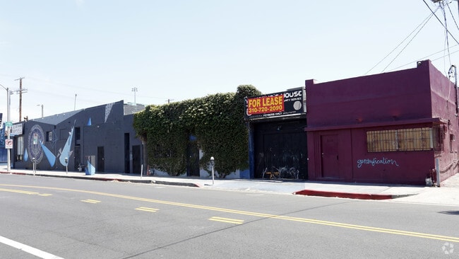
4318 Melrose Ave, Los Angeles, CA 90029


NEARBY LISTINGS FOR SALE OR LEASE
Property Detail
4318 Melrose Ave
Los Angeles-Long Beach-Glendale, CA
Pioneer Investment & Trust Cos
5538-030-019
PIONEER INVESTMENT AND TRUST COS WINDERMERE PARK (EX OF ST) LOTS 58 AND LOT 59
Restaurantbuilding
Los Angeles
AO
California
06037C1610F
58,59
2024
0.41 AC
2025
East Hollywood/Silver Lake
192610
Los Angeles
13,540 SF
DEMOGRAPHICS near 4318 Melrose Ave
1 Mile
3 Mile
5 Mile
2024 Total Population
84,118
543,506
1,076,815
2029 Population
82,296
532,066
1,050,746
Pop Growth 2024-2029
(2.17%)
(2.10%)
(2.42%)
Average Age
39
39
39
2024 Total Households
32,637
231,478
453,759
HH Growth 2024-2029
(2.45%)
(2.20%)
(2.43%)
Median Household Inc
$51,532
$56,106
$60,670
Avg Household Size
2.40
2.20
2.20
2024 Avg HH Vehicles
1.00
1.00
1.00
Median Home Value
$994,435
$1,052,833
$1,000,770
Median Year Built
1956
1961
1961
Nearby Places
Map Layers
Map Styles
 Street
 Aerial
- Restaurants
- Banks
- Shops
- Fitness
- Groceries
PUBLIC TRANSPORTATION
TRANSIT/SUBWAY
Vermont/Santa Monica Station (Red Line - Los Angeles County Metropolitan Transportation Authority (Metro))
DRIVE
WALK
Distance
Vermont/Santa Monica Station (Red Line - Los Angeles County Metropolitan Transportation Authority (Metro))
1 min
11 min
0.6 mi
Vermont/Beverly Station (Red Line - Los Angeles County Metropolitan Transportation Authority (Metro))
DRIVE
WALK
Distance
Vermont/Beverly Station (Red Line - Los Angeles County Metropolitan Transportation Authority (Metro))
1 min
12 min
0.7 mi
COMMUTER RAIL
Los Angeles (Coast Starlight - Amtrak, Pacific Surfliner - Amtrak, Southwest Chief - Amtrak, Texas Eagle - Amtrak)
DRIVE
WALK
Distance
Los Angeles (Coast Starlight - Amtrak, Pacific Surfliner - Amtrak, Southwest Chief - Amtrak, Texas Eagle - Amtrak)
7 min
4.3 mi
Glendale (Antelope Valley Line - Southern California Regional Rail Authority (Metrolink), Ventura County Line - Southern California Regional Rail Authority (Metrolink))
DRIVE
WALK
Distance
Glendale (Antelope Valley Line - Southern California Regional Rail Authority (Metrolink), Ventura County Line - Southern California Regional Rail Authority (Metrolink))
9 min
4.9 mi
AIRPORT
Bob Hope
DRIVE
WALK
Distance
Bob Hope
18 min
10.9 mi
Los Angeles International
DRIVE
WALK
Distance
Los Angeles International
26 min
15.6 mi
Long Beach (Daugherty Field)
DRIVE
WALK
Distance
Long Beach (Daugherty Field)
35 min
25.4 mi
Freight Ports
Port of Long Beach
DRIVE
WALK
Distance
Port of Long Beach
38 min
27.3 mi
SALE & LEASE HISTORY
LISTING DATE
SALE/LEASE

May 25, 2017
For Lease
Nearby Properties
Address
Land Use
TOTAL SIZE
Lot Size
Zoning
Address
Land Use
TOTAL SIZE
Lot Size
Zoning
930,249 SF
7.39 AC
LAC2
Address
Land Use
TOTAL SIZE
Lot Size
Zoning
709,584 SF
1.80 AC
LAPB
Address
Land Use
TOTAL SIZE
Lot Size
Zoning
161,046 SF
6.88 AC
LAM1
Address
Land Use
TOTAL SIZE
Lot Size
Zoning
67,126 SF
48.09 AC
LAM1
Address
Land Use
TOTAL SIZE
Lot Size
Zoning
641,453 SF
2.93 AC
LAC4
Address
Land Use
TOTAL SIZE
Lot Size
Zoning
497,377 SF
3.29 AC
LAC4
Address
Land Use
TOTAL SIZE
Lot Size
Zoning
651,289 SF
3.79 AC
LACW
Address
Land Use
TOTAL SIZE
Lot Size
Zoning
724,958 SF
5.88 AC
LAC2
Address
Land Use
TOTAL SIZE
Lot Size
Zoning
520,825 SF
2.13 AC
LAC2
Address
Land Use
TOTAL SIZE
Lot Size
Zoning
289,633 SF
1.55 AC
LAP
Address
Land Use
TOTAL SIZE
Lot Size
Zoning
746,938 SF
0.98 AC
LAC4
Address
Land Use
TOTAL SIZE
Lot Size
Zoning
556,235 SF
4.22 AC
LAC4
Address
Land Use
TOTAL SIZE
Lot Size
Zoning
406,948 SF
8.04 AC
LAC2
Address
Land Use
TOTAL SIZE
Lot Size
Zoning
341,221 SF
1.84 AC
LAC4
Address
Land Use
TOTAL SIZE
Lot Size
Zoning
490,689 SF
3.60 AC
LAM1
Address
Land Use
TOTAL SIZE
Lot Size
Zoning
256,032 SF
4.69 AC
LAC4
Address
Land Use
TOTAL SIZE
Lot Size
Zoning
216,433 SF
1.38 AC
LAR5
Address
Land Use
TOTAL SIZE
Lot Size
Zoning
320,944 SF
1.97 AC
LAC4
Address
Land Use
TOTAL SIZE
Lot Size
Zoning
264,720 SF
4.69 AC
LAC4
Address
Land Use
TOTAL SIZE
Lot Size
Zoning
310,063 SF
2.22 AC
LAC2
Address
Land Use
TOTAL SIZE
Lot Size
Zoning
93,785 SF
3.95 AC
LAR5
Address
Land Use
TOTAL SIZE
Lot Size
Zoning
347,880 SF
0.41 AC
LAC4
Address
Land Use
TOTAL SIZE
Lot Size
Zoning
292,714 SF
1.90 AC
LAR5
Address
Land Use
TOTAL SIZE
Lot Size
Zoning
347,123 SF
1.66 AC
Address
Land Use
TOTAL SIZE
Lot Size
Zoning
306,924 SF
2.11 AC
LAC4
Address
Land Use
TOTAL SIZE
Lot Size
Zoning
244,071 SF
1.64 AC
LARAS4
Address
Land Use
TOTAL SIZE
Lot Size
Zoning
961,271 SF
1.38 AC
LACW
Address
Land Use
TOTAL SIZE
Lot Size
Zoning
261,945 SF
1.24 AC
LAC4
Address
Land Use
TOTAL SIZE
Lot Size
Zoning
366,522 SF
1.11 AC
LAC2
The World's #1 Commercial Real Estate Marketplace
Connect with us
© 2026 CoStar Group
The information above has been obtained from sources believed reliable. While we do not doubt its accuracy we have not verified it and make no guarantee, warranty or representation about it. It is your responsibility to independently confirm its accuracy and completeness. Any projections, opinions, assumptions, or estimates used are for example only and do not represent the current or future performance of the property. The value of this transaction to you depends on tax and other factors which should be evaluated by your tax, financial, and legal advisors. You and your advisors should conduct a careful, independent investigation of the property to determine to your satisfaction the suitability of the property for your needs.