No Photo
Property Record
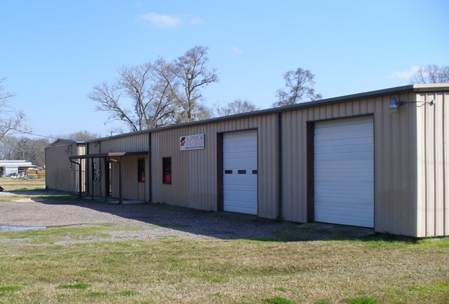
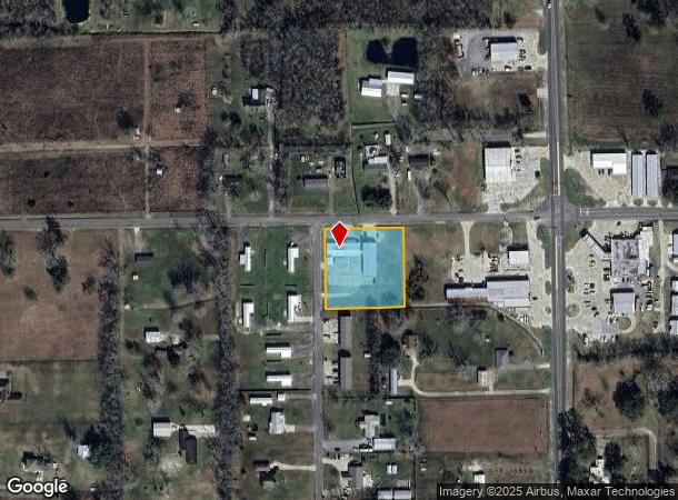
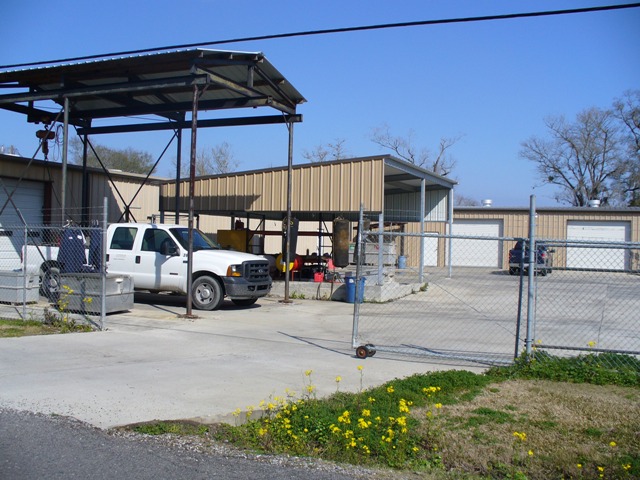
43469 Cannon Rd, Saint Amant, LA 70774
NEARBY LISTINGS FOR SALE OR LEASE
-
-
View all Saint Amant listings for sale on LoopNet.com
Property Detail
43469 Cannon Rd
Baton Rouge, LA
10 1 C
07904-000
1.62 AC. SEC. 23-9-3, TRACT 10-A
Officebuilding
Ascension
AE
Louisiana
22063C0375E
10a
2023
1.62 AC
2023
Ascension
030502
Baton Rouge
DEMOGRAPHICS near 43469 Cannon Rd
1 Mile
3 Mile
5 Mile
2024 Total Population
2,826
21,695
59,724
2029 Population
3,083
23,621
65,009
Pop Growth 2024-2029
+ 9.09%
+ 8.88%
+ 8.85%
Average Age
41
40
38
2024 Total Households
1,085
8,188
22,199
HH Growth 2024-2029
+ 9.40%
+ 9.12%
+ 9.09%
Median Household Inc
$71,026
$63,343
$64,113
Avg Household Size
2.60
2.60
2.60
2024 Avg HH Vehicles
2.00
2.00
2.00
Median Home Value
$209,794
$209,619
$206,291
Median Year Built
1992
1995
1999
Nearby Places
- Restaurants
- Banks
- Shops
- Fitness
- Groceries
PUBLIC TRANSPORTATION
AIRPORT
Baton Rouge Metro Ryan Field
DRIVE
WALK
Distance
Baton Rouge Metro Ryan Field
42 min
28.2 mi
Freight Ports
Port of Greater Baton Rouge
DRIVE
WALK
Distance
Port of Greater Baton Rouge
40 min
29.0 mi
Nearby Properties
Address
Land Use
TOTAL SIZE
Lot Size
Zoning
Address
Land Use
TOTAL SIZE
Lot Size
Zoning
Address
Land Use
TOTAL SIZE
Lot Size
Zoning
Address
Land Use
TOTAL SIZE
Lot Size
Zoning
20 AC
RM
Address
Land Use
TOTAL SIZE
Lot Size
Zoning
3.66 AC
Address
Land Use
TOTAL SIZE
Lot Size
Zoning
13.65 AC
Address
Land Use
TOTAL SIZE
Lot Size
Zoning
22.47 AC
RM
Address
Land Use
TOTAL SIZE
Lot Size
Zoning
16.18 AC
RM
Address
Land Use
TOTAL SIZE
Lot Size
Zoning
Address
Land Use
TOTAL SIZE
Lot Size
Zoning
7.12 AC
Address
Land Use
TOTAL SIZE
Lot Size
Zoning
5.64 AC
Address
Land Use
TOTAL SIZE
Lot Size
Zoning
2.78 AC
MU
Address
Land Use
TOTAL SIZE
Lot Size
Zoning
11.59 AC
Address
Land Use
TOTAL SIZE
Lot Size
Zoning
9.76 AC
Address
Land Use
TOTAL SIZE
Lot Size
Zoning
4.73 AC
Address
Land Use
TOTAL SIZE
Lot Size
Zoning
Address
Land Use
TOTAL SIZE
Lot Size
Zoning
1.03 AC
Address
Land Use
TOTAL SIZE
Lot Size
Zoning
1.53 AC
Address
Land Use
TOTAL SIZE
Lot Size
Zoning
Address
Land Use
TOTAL SIZE
Lot Size
Zoning
Address
Land Use
TOTAL SIZE
Lot Size
Zoning
Address
Land Use
TOTAL SIZE
Lot Size
Zoning
3.75 AC
MU
Address
Land Use
TOTAL SIZE
Lot Size
Zoning
2.34 AC
Address
Land Use
TOTAL SIZE
Lot Size
Zoning
3.25 AC
Address
Land Use
TOTAL SIZE
Lot Size
Zoning
2.57 AC
Address
Land Use
TOTAL SIZE
Lot Size
Zoning
2.03 AC
Address
Land Use
TOTAL SIZE
Lot Size
Zoning
1.29 AC
CC
Address
Land Use
TOTAL SIZE
Lot Size
Zoning
6.55 AC
MU
Address
Land Use
TOTAL SIZE
Lot Size
Zoning
20.14 AC
R
Address
Land Use
TOTAL SIZE
Lot Size
Zoning
1.71 AC
CC
Address
Land Use
TOTAL SIZE
Lot Size
Zoning
2.26 AC
The World's #1 Commercial Real Estate Marketplace
Connect with us
© 2025 CoStar Group
The information above has been obtained from sources believed reliable. While we do not doubt its accuracy we have not verified it and make no guarantee, warranty or representation about it. It is your responsibility to independently confirm its accuracy and completeness. Any projections, opinions, assumptions, or estimates used are for example only and do not represent the current or future performance of the property. The value of this transaction to you depends on tax and other factors which should be evaluated by your tax, financial, and legal advisors. You and your advisors should conduct a careful, independent investigation of the property to determine to your satisfaction the suitability of the property for your needs.