Property Record
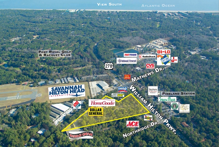
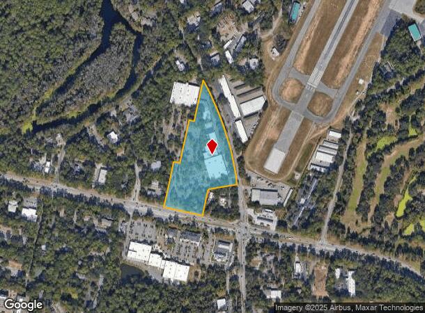
435 William Hilton Pkwy, Hilton Head Island, SC 29926

NEARBY LISTINGS FOR SALE OR LEASE
Property Detail
435 William Hilton Pkwy
Hilton Head Island-Bluffton-Beaufort, SC
No. Hhi Zoned Cc&Nc&Pud1-Comm
R511-008-000-0254-0000
PAR 1 PHASE 1 NORTHRIDGE PARK PB31P14 PB47 P150
Communitycenter
Beaufort
2024
South Carolina
2024
10.23 AC
010800
Hilton Head/Beaufort
35,880 SF
Other Market Areas
DEMOGRAPHICS near 435 William Hilton Pkwy
1 Mile
3 Mile
5 Mile
2024 Total Population
4,437
24,946
37,675
2029 Population
5,034
28,577
43,390
Pop Growth 2024-2029
+ 13.46%
+ 14.56%
+ 15.17%
Average Age
44
50
52
2024 Total Households
1,789
10,980
16,833
HH Growth 2024-2029
+ 12.91%
+ 14.44%
+ 15.09%
Median Household Inc
$44,911
$79,559
$84,735
Avg Household Size
2.40
2.20
2.20
2024 Avg HH Vehicles
1.00
2.00
2.00
Median Home Value
$478,861
$498,648
$561,558
Median Year Built
1989
1989
1989
Nearby Places
- Restaurants
- Banks
- Shops
- Fitness
- Groceries
PUBLIC TRANSPORTATION
AIRPORT
Savannah/Hilton Head International
DRIVE
WALK
Distance
Savannah/Hilton Head International
49 min
42.2 mi
SALE & LEASE HISTORY
LISTING DATE
SALE/LEASE

Sep 25, 2016
For Lease
Jun 23, 2017
For Lease
Nearby Properties
Address
Land Use
TOTAL SIZE
Lot Size
Zoning
Address
Land Use
TOTAL SIZE
Lot Size
Zoning
700,966 SF
17.85 AC
6615
Address
Land Use
TOTAL SIZE
Lot Size
Zoning
99,058 SF
30.34 AC
6615
Address
Land Use
TOTAL SIZE
Lot Size
Zoning
16,424 SF
13.89 AC
6615
Address
Land Use
TOTAL SIZE
Lot Size
Zoning
3,400 SF
4.97 AC
Address
Land Use
TOTAL SIZE
Lot Size
Zoning
313,171 SF
4.45 AC
Address
Land Use
TOTAL SIZE
Lot Size
Zoning
Address
Land Use
TOTAL SIZE
Lot Size
Zoning
145,864 SF
49.71 AC
6615
Address
Land Use
TOTAL SIZE
Lot Size
Zoning
187,534 SF
14.92 AC
6615
Address
Land Use
TOTAL SIZE
Lot Size
Zoning
980 SF
38.06 AC
6615
Address
Land Use
TOTAL SIZE
Lot Size
Zoning
123,912 SF
21.80 AC
6615
Address
Land Use
TOTAL SIZE
Lot Size
Zoning
133,565 SF
44 AC
6615
Address
Land Use
TOTAL SIZE
Lot Size
Zoning
7,488 SF
10 AC
6615
Address
Land Use
TOTAL SIZE
Lot Size
Zoning
80,867 SF
11.29 AC
6615
Address
Land Use
TOTAL SIZE
Lot Size
Zoning
31,200 SF
10.60 AC
6615
Address
Land Use
TOTAL SIZE
Lot Size
Zoning
93,782 SF
7.61 AC
6615
Address
Land Use
TOTAL SIZE
Lot Size
Zoning
71,118 SF
13.61 AC
6615
Address
Land Use
TOTAL SIZE
Lot Size
Zoning
57,094 SF
12.38 AC
6615
Address
Land Use
TOTAL SIZE
Lot Size
Zoning
13,380 SF
5.74 AC
6615
Address
Land Use
TOTAL SIZE
Lot Size
Zoning
45,195 SF
5.98 AC
6605
Address
Land Use
TOTAL SIZE
Lot Size
Zoning
101,646 SF
8.17 AC
6615
Address
Land Use
TOTAL SIZE
Lot Size
Zoning
19,729 SF
5.46 AC
6615
Address
Land Use
TOTAL SIZE
Lot Size
Zoning
65,416 SF
354.63 AC
6615
Address
Land Use
TOTAL SIZE
Lot Size
Zoning
19,289 SF
13.95 AC
6615
Address
Land Use
TOTAL SIZE
Lot Size
Zoning
13,680 SF
5.50 AC
6615
Address
Land Use
TOTAL SIZE
Lot Size
Zoning
10,164 SF
62.14 AC
6615
Address
Land Use
TOTAL SIZE
Lot Size
Zoning
192 SF
70.94 AC
6615
Address
Land Use
TOTAL SIZE
Lot Size
Zoning
4,988 SF
5.30 AC
FM
Address
Land Use
TOTAL SIZE
Lot Size
Zoning
13,920 SF
479.52 AC
6615
Address
Land Use
TOTAL SIZE
Lot Size
Zoning
9,848 SF
4.92 AC
6615
The World's #1 Commercial Real Estate Marketplace
Connect with us
© 2025 CoStar Group
The information above has been obtained from sources believed reliable. While we do not doubt its accuracy we have not verified it and make no guarantee, warranty or representation about it. It is your responsibility to independently confirm its accuracy and completeness. Any projections, opinions, assumptions, or estimates used are for example only and do not represent the current or future performance of the property. The value of this transaction to you depends on tax and other factors which should be evaluated by your tax, financial, and legal advisors. You and your advisors should conduct a careful, independent investigation of the property to determine to your satisfaction the suitability of the property for your needs.