Property Record
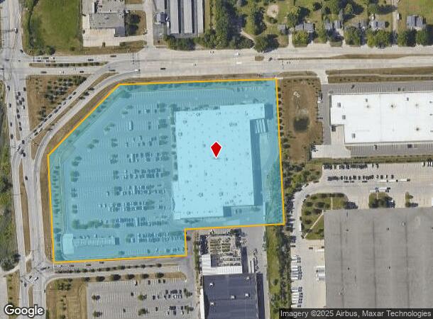
4350 Joslyn Rd, Auburn Hills, MI 48326
NEARBY LISTINGS FOR SALE OR LEASE
Property Detail
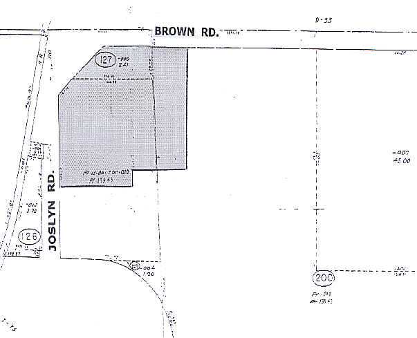
4350 Joslyn Rd
14-04-127-009
T3N, R10E, SEC 4 PART OF N 1/2 OF SEC BEG AT PT DIST S 06-02-24 E 113.22 FT FROM N 1/4 COR, TH N 87-32-55 E 254.66 FT, TH S 03-45-25 E 586.19 FT, TH S 86-14-35 W 404.44 FT, TH S 03-45-25 E 107.50 FT, TH S 86-14-35 W 538 FT, TH N 03-45-25 W 433.34 FT,
Wholesaleoutletdiscountstore
Oakland
X
Michigan
26125C0358F
13.26 AC
2024
Pontiac
2024
Detroit
981400
Detroit-Warren-Dearborn, MI
134,544 SF
DEMOGRAPHICS near 4350 Joslyn Rd
1 Mile
3 Mile
5 Mile
2024 Total Population
601
38,513
128,667
2029 Population
607
38,460
128,131
Pop Growth 2024-2029
+ 1.00%
(0.14%)
(0.42%)
Average Age
40
38
39
2024 Total Households
226
15,694
49,765
HH Growth 2024-2029
+ 0.88%
(0.25%)
(0.48%)
Median Household Inc
$76,293
$63,774
$70,837
Avg Household Size
2.50
2.40
2.40
2024 Avg HH Vehicles
2.00
2.00
2.00
Median Home Value
$285,416
$222,018
$275,576
Median Year Built
1991
1980
1976
Nearby Places
- Restaurants
- Banks
- Shops
- Fitness
- Groceries
PUBLIC TRANSPORTATION
COMMUTER RAIL
Pontiac Amtrak Station (Wolverine - Amtrak)
DRIVE
WALK
Distance
Pontiac Amtrak Station (Wolverine - Amtrak)
14 min
5.8 mi
AIRPORT
Bishop International
DRIVE
WALK
Distance
Bishop International
51 min
35.3 mi
Freight Ports
Port of Toledo
DRIVE
WALK
Distance
Port of Toledo
113 min
93.5 mi
Nearby Properties
Address
Land Use
TOTAL SIZE
Lot Size
Zoning
Address
Land Use
TOTAL SIZE
Lot Size
Zoning
1,421,000 SF
170.30 AC
B2
Address
Land Use
TOTAL SIZE
Lot Size
Zoning
6,255,758 SF
Address
Land Use
TOTAL SIZE
Lot Size
Zoning
527,000 SF
36.03 AC
Address
Land Use
TOTAL SIZE
Lot Size
Zoning
316,358 SF
20.89 AC
P
Address
Land Use
TOTAL SIZE
Lot Size
Zoning
420,858 SF
65.07 AC
Address
Land Use
TOTAL SIZE
Lot Size
Zoning
891,314 SF
60.90 AC
II
Address
Land Use
TOTAL SIZE
Lot Size
Zoning
430,338 SF
46.09 AC
Address
Land Use
TOTAL SIZE
Lot Size
Zoning
6,255,758 SF
Address
Land Use
TOTAL SIZE
Lot Size
Zoning
6,255,758 SF
223.95 AC
Address
Land Use
TOTAL SIZE
Lot Size
Zoning
6,255,758 SF
233.05 AC
II
Address
Land Use
TOTAL SIZE
Lot Size
Zoning
246,150 SF
26.64 AC
TR
Address
Land Use
TOTAL SIZE
Lot Size
Zoning
247,500 SF
Address
Land Use
TOTAL SIZE
Lot Size
Zoning
430,338 SF
43.22 AC
Address
Land Use
TOTAL SIZE
Lot Size
Zoning
347,979 SF
58.38 AC
AI
Address
Land Use
TOTAL SIZE
Lot Size
Zoning
213,112 SF
12.17 AC
I1
Address
Land Use
TOTAL SIZE
Lot Size
Zoning
329,335 SF
17.40 AC
Address
Land Use
TOTAL SIZE
Lot Size
Zoning
455,045 SF
23.47 AC
I1
Address
Land Use
TOTAL SIZE
Lot Size
Zoning
70,710 SF
13.38 AC
BI
Address
Land Use
TOTAL SIZE
Lot Size
Zoning
232,860 SF
28.30 AC
I1
Address
Land Use
TOTAL SIZE
Lot Size
Zoning
174,019 SF
9.66 AC
Address
Land Use
TOTAL SIZE
Lot Size
Zoning
186,242 SF
Address
Land Use
TOTAL SIZE
Lot Size
Zoning
136,061 SF
14.64 AC
Address
Land Use
TOTAL SIZE
Lot Size
Zoning
30,720 SF
103.14 AC
I2
Address
Land Use
TOTAL SIZE
Lot Size
Zoning
173,974 SF
31.37 AC
TR
Address
Land Use
TOTAL SIZE
Lot Size
Zoning
171,242 SF
11.86 AC
Address
Land Use
TOTAL SIZE
Lot Size
Zoning
148,825 SF
Address
Land Use
TOTAL SIZE
Lot Size
Zoning
142,858 SF
Address
Land Use
TOTAL SIZE
Lot Size
Zoning
124,104 SF
Address
Land Use
TOTAL SIZE
Lot Size
Zoning
245,436 SF
Address
Land Use
TOTAL SIZE
Lot Size
Zoning
180,852 SF
40.32 AC
AI
The World's #1 Commercial Real Estate Marketplace
Connect with us
© 2025 CoStar Group
The information above has been obtained from sources believed reliable. While we do not doubt its accuracy we have not verified it and make no guarantee, warranty or representation about it. It is your responsibility to independently confirm its accuracy and completeness. Any projections, opinions, assumptions, or estimates used are for example only and do not represent the current or future performance of the property. The value of this transaction to you depends on tax and other factors which should be evaluated by your tax, financial, and legal advisors. You and your advisors should conduct a careful, independent investigation of the property to determine to your satisfaction the suitability of the property for your needs.