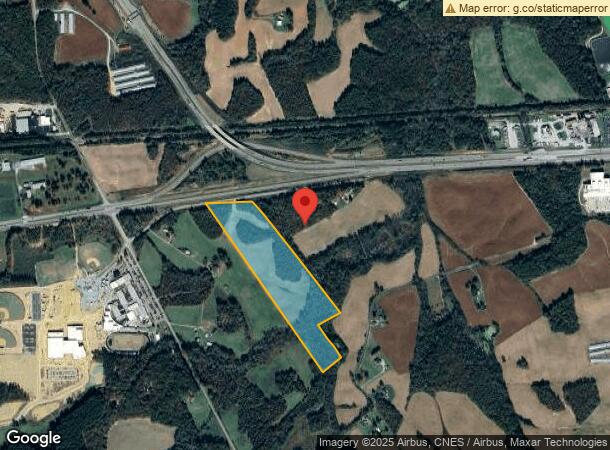
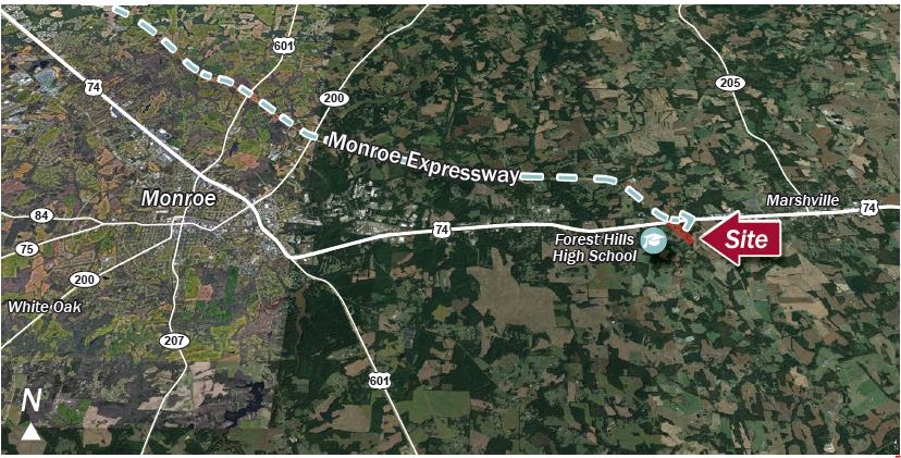
Property Record
436 Flint Rock Rd, Marshville, NC 28103

NEARBY LISTINGS FOR SALE OR LEASE
-
-
View all Marshville listings for sale on LoopNet.com
Property Detail
436 Flint Rock Rd
02-214-032
OPCK910 29.494AC
Agriculturalland
Union
X
North Carolina
3710547500J
29.49 AC
2024
Union County
2024
Charlotte
020800
Charlotte-Concord-Gastonia, NC-SC
DEMOGRAPHICS near 436 Flint Rock Rd
1 Mile
3 Mile
5 Mile
2024 Total Population
351
9,014
14,304
2029 Population
381
9,876
15,788
Pop Growth 2024-2029
+ 8.55%
+ 9.56%
+ 10.37%
Average Age
34
36
38
2024 Total Households
75
2,619
4,522
HH Growth 2024-2029
+ 12.00%
+ 10.81%
+ 11.30%
Median Household Inc
$53,000
$54,188
$57,628
Avg Household Size
2.60
2.70
2.70
2024 Avg HH Vehicles
2.00
2.00
2.00
Median Home Value
$221,428
$180,960
$209,386
Median Year Built
1983
1983
1984
Nearby Places
- Restaurants
- Banks
- Shops
- Fitness
- Groceries
SALE & LEASE HISTORY
LISTING DATE
SALE/LEASE

Sep 24, 2016
For Sale
Jul 21, 2017
For Sale
Aug 11, 2017
For Sale
Nearby Properties
Address
Land Use
TOTAL SIZE
Lot Size
Zoning
Address
Land Use
TOTAL SIZE
Lot Size
Zoning
68,258 SF
3.39 AC
R-20 WINGA
Address
Land Use
TOTAL SIZE
Lot Size
Zoning
17,304 SF
0.61 AC
B-6 WINGAT
Address
Land Use
TOTAL SIZE
Lot Size
Zoning
138,165 SF
135.17 AC
HC UNION C
Address
Land Use
TOTAL SIZE
Lot Size
Zoning
28,468 SF
3.51 AC
B-1 WINGAT
Address
Land Use
TOTAL SIZE
Lot Size
Zoning
64,743 SF
13.82 AC
R-20 WINGA
Address
Land Use
TOTAL SIZE
Lot Size
Zoning
69,549 SF
13 AC
IND MARSHV
Address
Land Use
TOTAL SIZE
Lot Size
Zoning
138,123 SF
113.13 AC
B-1 WINGAT
Address
Land Use
TOTAL SIZE
Lot Size
Zoning
28.93 AC
Address
Land Use
TOTAL SIZE
Lot Size
Zoning
24.89 AC
Address
Land Use
TOTAL SIZE
Lot Size
Zoning
88,806 SF
15.72 AC
IND MARSHV
Address
Land Use
TOTAL SIZE
Lot Size
Zoning
26,600 SF
161.03 AC
RA-40 UNIO
Address
Land Use
TOTAL SIZE
Lot Size
Zoning
74,070 SF
15.61 AC
CIV MARSHV
Address
Land Use
TOTAL SIZE
Lot Size
Zoning
47,416 SF
10.41 AC
TMU MARSHV
Address
Land Use
TOTAL SIZE
Lot Size
Zoning
73,033 SF
15.12 AC
CIV MARSHV
Address
Land Use
TOTAL SIZE
Lot Size
Zoning
28,512 SF
13.74 AC
B-1 WINGAT
Address
Land Use
TOTAL SIZE
Lot Size
Zoning
15,103 SF
2.01 AC
B-1 WINGAT
Address
Land Use
TOTAL SIZE
Lot Size
Zoning
25,430 SF
8.59 AC
CIV MARSHV
Address
Land Use
TOTAL SIZE
Lot Size
Zoning
563.78 AC
RA-20 WING
Address
Land Use
TOTAL SIZE
Lot Size
Zoning
32,536 SF
4.91 AC
C-74 MARSH
Address
Land Use
TOTAL SIZE
Lot Size
Zoning
15,928 SF
3.87 AC
CIV MARSHV
Address
Land Use
TOTAL SIZE
Lot Size
Zoning
25,794 SF
1.80 AC
R-6 WINGAT
Address
Land Use
TOTAL SIZE
Lot Size
Zoning
21,804 SF
0.48 AC
R-20 WINGA
Address
Land Use
TOTAL SIZE
Lot Size
Zoning
21,804 SF
0.92 AC
R-6 WINGAT
Address
Land Use
TOTAL SIZE
Lot Size
Zoning
12,017 SF
1.60 AC
MS MARSHVI
Address
Land Use
TOTAL SIZE
Lot Size
Zoning
8,712 SF
0.37 AC
B-6 WINGAT
Address
Land Use
TOTAL SIZE
Lot Size
Zoning
8,375 SF
1.25 AC
CIV MARSHV
Address
Land Use
TOTAL SIZE
Lot Size
Zoning
16,000 SF
7.95 AC
IND MARSHV
Address
Land Use
TOTAL SIZE
Lot Size
Zoning
16,401 SF
1.02 AC
R-6 WINGAT
Address
Land Use
TOTAL SIZE
Lot Size
Zoning
10,274 SF
6.24 AC
R-6 WINGAT
Address
Land Use
TOTAL SIZE
Lot Size
Zoning
4,252 SF
2.60 AC
R-6 WINGAT
The World's #1 Commercial Real Estate Marketplace
Connect with us
© 2025 CoStar Group
The information above has been obtained from sources believed reliable. While we do not doubt its accuracy we have not verified it and make no guarantee, warranty or representation about it. It is your responsibility to independently confirm its accuracy and completeness. Any projections, opinions, assumptions, or estimates used are for example only and do not represent the current or future performance of the property. The value of this transaction to you depends on tax and other factors which should be evaluated by your tax, financial, and legal advisors. You and your advisors should conduct a careful, independent investigation of the property to determine to your satisfaction the suitability of the property for your needs.