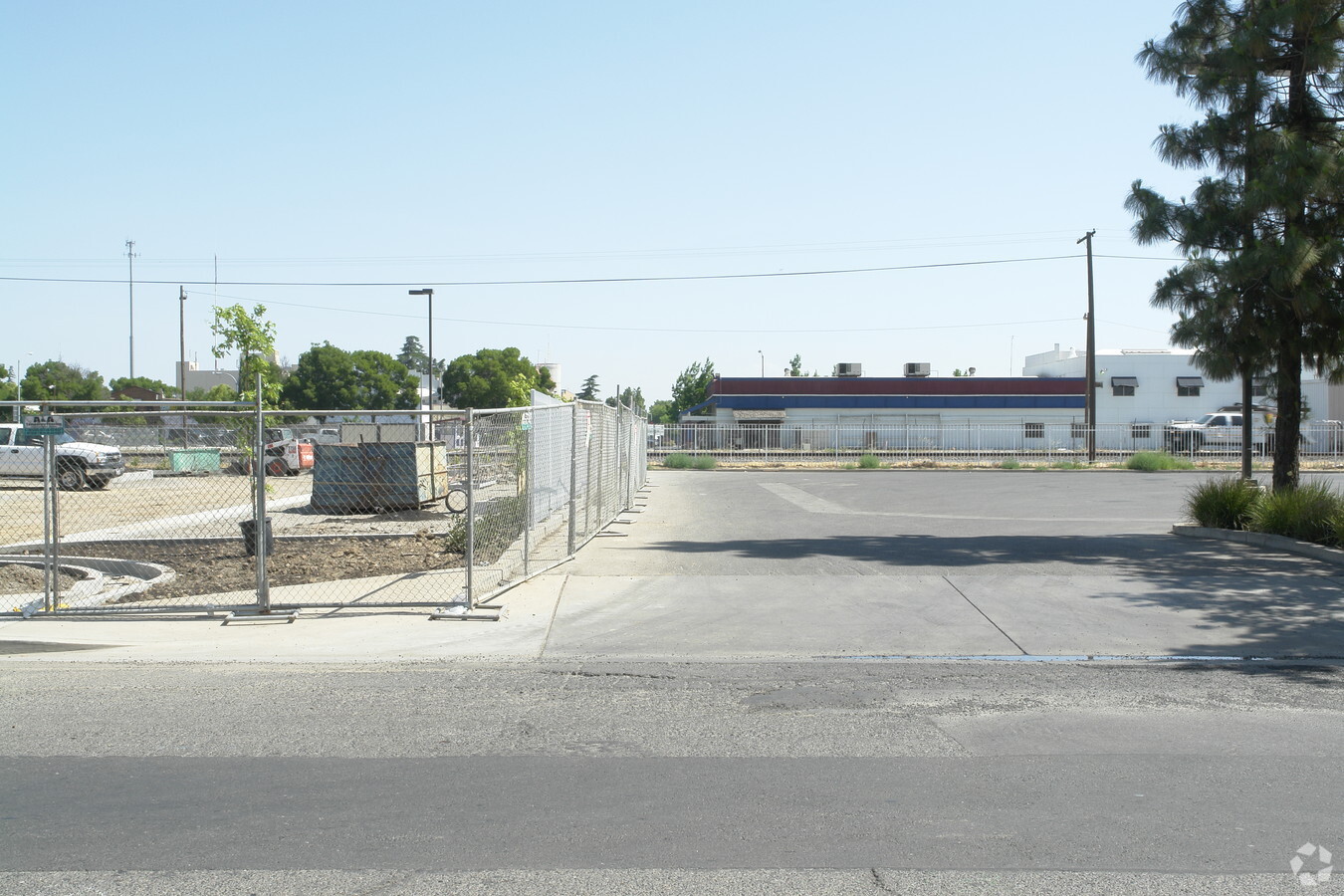
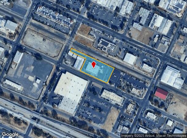
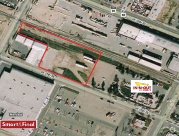
Property Record
439 W 15Th St, Merced, CA 95340

NEARBY LISTINGS FOR SALE OR LEASE
Property Detail
439 W 15Th St
Merced, CA
Southern Pacific Transportatio
031-360-047
PARCEL 3 PM 75-34 SEC 30/7/14
Commercialnec
Merced
AO
California
06047C0440G
3
2023
1.30 AC
2024
Downtown Merced
001302
Fresno
DEMOGRAPHICS near 439 W 15Th St
1 Mile
3 Mile
5 Mile
2024 Total Population
17,873
96,073
116,454
2029 Population
19,244
103,872
126,120
Pop Growth 2024-2029
+ 7.67%
+ 8.12%
+ 8.30%
Average Age
34
35
34
2024 Total Households
5,686
30,259
35,886
HH Growth 2024-2029
+ 7.83%
+ 8.22%
+ 8.42%
Median Household Inc
$28,281
$47,726
$51,061
Avg Household Size
3.00
3.00
3.10
2024 Avg HH Vehicles
2.00
2.00
2.00
Median Home Value
$245,840
$315,474
$331,469
Median Year Built
1963
1981
1984
Nearby Places
- Restaurants
- Banks
- Shops
- Fitness
- Groceries
PUBLIC TRANSPORTATION
COMMUTER RAIL
Merced (San Joaquins - Amtrak)
DRIVE
WALK
Distance
Merced (San Joaquins - Amtrak)
2 min
16 min
0.9 mi
Freight Ports
Port of Stockton
DRIVE
WALK
Distance
Port of Stockton
87 min
72.3 mi
Nearby Properties
Address
Land Use
TOTAL SIZE
Lot Size
Zoning
Address
Land Use
TOTAL SIZE
Lot Size
Zoning
17.50 AC
CO
Address
Land Use
TOTAL SIZE
Lot Size
Zoning
7,182 SF
14.73 AC
R32
Address
Land Use
TOTAL SIZE
Lot Size
Zoning
7.80 AC
IL
Address
Land Use
TOTAL SIZE
Lot Size
Zoning
12.35 AC
CG
Address
Land Use
TOTAL SIZE
Lot Size
Zoning
4.87 AC
PD
Address
Land Use
TOTAL SIZE
Lot Size
Zoning
10.18 AC
R16
Address
Land Use
TOTAL SIZE
Lot Size
Zoning
2.90 AC
CO
Address
Land Use
TOTAL SIZE
Lot Size
Zoning
3.50 AC
R4
Address
Land Use
TOTAL SIZE
Lot Size
Zoning
8.44 AC
PD
Address
Land Use
TOTAL SIZE
Lot Size
Zoning
27.32 AC
PD
Address
Land Use
TOTAL SIZE
Lot Size
Zoning
18.40 AC
IL
Address
Land Use
TOTAL SIZE
Lot Size
Zoning
28.36 AC
Address
Land Use
TOTAL SIZE
Lot Size
Zoning
1.70 AC
CO
Address
Land Use
TOTAL SIZE
Lot Size
Zoning
3.90 AC
PD
Address
Land Use
TOTAL SIZE
Lot Size
Zoning
11.57 AC
IL
Address
Land Use
TOTAL SIZE
Lot Size
Zoning
2 AC
PD
Address
Land Use
TOTAL SIZE
Lot Size
Zoning
0.48 AC
CC
Address
Land Use
TOTAL SIZE
Lot Size
Zoning
11.80 AC
PD
Address
Land Use
TOTAL SIZE
Lot Size
Zoning
10 AC
PD
Address
Land Use
TOTAL SIZE
Lot Size
Zoning
1.80 AC
Address
Land Use
TOTAL SIZE
Lot Size
Zoning
21.74 AC
IL
Address
Land Use
TOTAL SIZE
Lot Size
Zoning
9.30 AC
IH
Address
Land Use
TOTAL SIZE
Lot Size
Zoning
4.50 AC
R4
Address
Land Use
TOTAL SIZE
Lot Size
Zoning
10.30 AC
CT
Address
Land Use
TOTAL SIZE
Lot Size
Zoning
1.90 AC
CT
Address
Land Use
TOTAL SIZE
Lot Size
Zoning
6,296 SF
3.30 AC
Address
Land Use
TOTAL SIZE
Lot Size
Zoning
0.36 AC
PD
Address
Land Use
TOTAL SIZE
Lot Size
Zoning
0.34 AC
CC
Address
Land Use
TOTAL SIZE
Lot Size
Zoning
8,014 SF
5.92 AC
RPD
Address
Land Use
TOTAL SIZE
Lot Size
Zoning
40 AC
IH
The World's #1 Commercial Real Estate Marketplace
Connect with us
© 2025 CoStar Group
The information above has been obtained from sources believed reliable. While we do not doubt its accuracy we have not verified it and make no guarantee, warranty or representation about it. It is your responsibility to independently confirm its accuracy and completeness. Any projections, opinions, assumptions, or estimates used are for example only and do not represent the current or future performance of the property. The value of this transaction to you depends on tax and other factors which should be evaluated by your tax, financial, and legal advisors. You and your advisors should conduct a careful, independent investigation of the property to determine to your satisfaction the suitability of the property for your needs.