Property Record
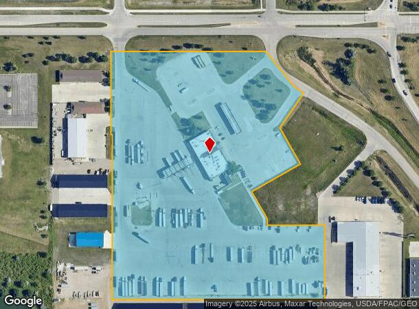
4401 32Nd Ave S, Grand Forks, ND 58201


NEARBY LISTINGS FOR SALE OR LEASE
Property Detail
4401 32Nd Ave S
Grand Forks, ND-MN
Columbia Park 22Nd Addition
44133800001004
4401 32ND AVE S LOT D BLK 1 (REPLAT OF LOT A OF THE REPLAT OF LOT 1)
Commercialnec
Grand Forks
X
North Dakota
38035C0589E
a,d,1
2023
15.19 AC
2023
North Dakota Area
011702
Other Market Areas
15,246 SF
DEMOGRAPHICS near 4401 32Nd Ave S
1 Mile
3 Mile
5 Mile
2024 Total Population
3,692
44,740
67,884
2029 Population
3,644
44,404
67,155
Pop Growth 2024-2029
(1.30%)
(0.75%)
(1.07%)
Average Age
36
35
36
2024 Total Households
1,777
19,246
28,770
HH Growth 2024-2029
(1.46%)
(0.88%)
(1.17%)
Median Household Inc
$61,488
$57,608
$60,815
Avg Household Size
1.90
2.10
2.20
2024 Avg HH Vehicles
2.00
2.00
2.00
Median Home Value
$303,125
$243,586
$241,356
Median Year Built
2000
1988
1981
Nearby Places
- Restaurants
- Banks
- Shops
- Fitness
- Groceries
PUBLIC TRANSPORTATION
COMMUTER RAIL
Grand Forks Amtrak Station (Empire Builder - Amtrak)
DRIVE
WALK
Distance
Grand Forks Amtrak Station (Empire Builder - Amtrak)
7 min
3.6 mi
AIRPORT
Grand Forks International
DRIVE
WALK
Distance
Grand Forks International
13 min
8.6 mi
Freight Ports
Port Milwaukee
DRIVE
WALK
Distance
Port Milwaukee
710 min
648.4 mi
Nearby Properties
Address
Land Use
TOTAL SIZE
Lot Size
Zoning
Address
Land Use
TOTAL SIZE
Lot Size
Zoning
93,530 SF
4.54 AC
Address
Land Use
TOTAL SIZE
Lot Size
Zoning
207,100 SF
10 AC
Address
Land Use
TOTAL SIZE
Lot Size
Zoning
16.53 AC
Address
Land Use
TOTAL SIZE
Lot Size
Zoning
181,020 SF
13.50 AC
Address
Land Use
TOTAL SIZE
Lot Size
Zoning
Address
Land Use
TOTAL SIZE
Lot Size
Zoning
107,954 SF
3.60 AC
Address
Land Use
TOTAL SIZE
Lot Size
Zoning
Address
Land Use
TOTAL SIZE
Lot Size
Zoning
Address
Land Use
TOTAL SIZE
Lot Size
Zoning
172,013 SF
8.14 AC
Address
Land Use
TOTAL SIZE
Lot Size
Zoning
198,253 SF
2.76 AC
Address
Land Use
TOTAL SIZE
Lot Size
Zoning
173,317 SF
15.40 AC
Address
Land Use
TOTAL SIZE
Lot Size
Zoning
147,161 SF
4.22 AC
Address
Land Use
TOTAL SIZE
Lot Size
Zoning
19.06 AC
Address
Land Use
TOTAL SIZE
Lot Size
Zoning
224,308 SF
18.59 AC
Address
Land Use
TOTAL SIZE
Lot Size
Zoning
185,550 SF
14.10 AC
Address
Land Use
TOTAL SIZE
Lot Size
Zoning
Address
Land Use
TOTAL SIZE
Lot Size
Zoning
Address
Land Use
TOTAL SIZE
Lot Size
Zoning
104,672 SF
3.64 AC
Address
Land Use
TOTAL SIZE
Lot Size
Zoning
53,181 SF
6.46 AC
Address
Land Use
TOTAL SIZE
Lot Size
Zoning
152,729 SF
9.44 AC
Address
Land Use
TOTAL SIZE
Lot Size
Zoning
140,040 SF
6.33 AC
Address
Land Use
TOTAL SIZE
Lot Size
Zoning
157,264 SF
5.99 AC
Address
Land Use
TOTAL SIZE
Lot Size
Zoning
148,083 SF
7.35 AC
Address
Land Use
TOTAL SIZE
Lot Size
Zoning
129,480 SF
10.85 AC
Address
Land Use
TOTAL SIZE
Lot Size
Zoning
158,412 SF
8.91 AC
Address
Land Use
TOTAL SIZE
Lot Size
Zoning
69,296 SF
7.04 AC
Address
Land Use
TOTAL SIZE
Lot Size
Zoning
Address
Land Use
TOTAL SIZE
Lot Size
Zoning
Address
Land Use
TOTAL SIZE
Lot Size
Zoning
119,267 SF
4.10 AC
Address
Land Use
TOTAL SIZE
Lot Size
Zoning
56,280 SF
10.50 AC
The World's #1 Commercial Real Estate Marketplace
Connect with us
© 2025 CoStar Group
The information above has been obtained from sources believed reliable. While we do not doubt its accuracy we have not verified it and make no guarantee, warranty or representation about it. It is your responsibility to independently confirm its accuracy and completeness. Any projections, opinions, assumptions, or estimates used are for example only and do not represent the current or future performance of the property. The value of this transaction to you depends on tax and other factors which should be evaluated by your tax, financial, and legal advisors. You and your advisors should conduct a careful, independent investigation of the property to determine to your satisfaction the suitability of the property for your needs.