Property Record
44075 Route 25, Peconic, NY 11958
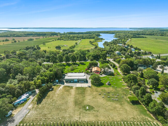
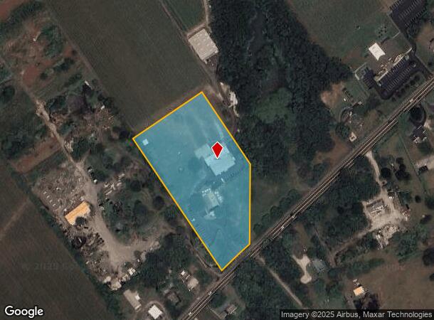
This Property Is For Sale
NEARBY LISTINGS FOR SALE OR LEASE
-
-
View all Peconic listings for sale on LoopNet.com
Property Detail
44075 Route 25
Nassau County-Suffolk County, NY
BOOK 11618 PAGE 440 BILL 008695
1000-075-00-01-00-020-001
Suffolk
Vineyard
New York
X
20
36103C0162H
4.46 AC
2024
Eastern Suffolk
2024
Long Island (New York)
170006
DEMOGRAPHICS near 44075 Route 25
1 Mile
3 Mile
5 Mile
2024 Total Population
988
10,884
15,475
2029 Population
1,020
11,277
15,960
Pop Growth 2024-2029
+ 3.24%
+ 3.61%
+ 3.13%
Average Age
48
49
49
2024 Total Households
409
4,630
6,552
HH Growth 2024-2029
+ 3.18%
+ 3.56%
+ 3.07%
Median Household Inc
$84,114
$103,926
$102,808
Avg Household Size
2.40
2.30
2.30
2024 Avg HH Vehicles
2.00
2.00
2.00
Median Home Value
$736,788
$747,360
$752,405
Median Year Built
1970
1974
1974
Nearby Places
Map Layers
Map Styles
 Street
 Aerial
- Restaurants
- Banks
- Shops
- Fitness
- Groceries
PUBLIC TRANSPORTATION
COMMUTER RAIL
Southold Station (Greenport Branch - Long Island Rail Road)
DRIVE
WALK
Distance
Southold Station (Greenport Branch - Long Island Rail Road)
5 min
2.2 mi
Mattituck Station (Greenport Branch - Long Island Rail Road)
DRIVE
WALK
Distance
Mattituck Station (Greenport Branch - Long Island Rail Road)
11 min
6.8 mi
Freight Ports
Port of New Haven
DRIVE
WALK
Distance
Port of New Haven
169 min
73.3 mi
Nearby Properties
Address
Land Use
TOTAL SIZE
Lot Size
Zoning
Address
Land Use
TOTAL SIZE
Lot Size
Zoning
38.11 AC
R-40 RO
Address
Land Use
TOTAL SIZE
Lot Size
Zoning
0.35 AC
HD
Address
Land Use
TOTAL SIZE
Lot Size
Zoning
26.14 AC
R-80
Address
Land Use
TOTAL SIZE
Lot Size
Zoning
0.02 AC
Address
Land Use
TOTAL SIZE
Lot Size
Zoning
2.60 AC
HB
Address
Land Use
TOTAL SIZE
Lot Size
Zoning
0.02 AC
Address
Land Use
TOTAL SIZE
Lot Size
Zoning
Address
Land Use
TOTAL SIZE
Lot Size
Zoning
17.34 AC
Address
Land Use
TOTAL SIZE
Lot Size
Zoning
12.10 AC
R-80 B
Address
Land Use
TOTAL SIZE
Lot Size
Zoning
3.20 AC
R-80
Address
Land Use
TOTAL SIZE
Lot Size
Zoning
Address
Land Use
TOTAL SIZE
Lot Size
Zoning
10.50 AC
R-40
Address
Land Use
TOTAL SIZE
Lot Size
Zoning
4.91 AC
B
Address
Land Use
TOTAL SIZE
Lot Size
Zoning
78.34 AC
AC
Address
Land Use
TOTAL SIZE
Lot Size
Zoning
4.33 AC
R-40 RO
Address
Land Use
TOTAL SIZE
Lot Size
Zoning
Address
Land Use
TOTAL SIZE
Lot Size
Zoning
4.33 AC
R-80
Address
Land Use
TOTAL SIZE
Lot Size
Zoning
36.62 AC
R-80
Address
Land Use
TOTAL SIZE
Lot Size
Zoning
7.20 AC
AC
Address
Land Use
TOTAL SIZE
Lot Size
Zoning
72.30 AC
AC R-80
Address
Land Use
TOTAL SIZE
Lot Size
Zoning
6 AC
R-40
Address
Land Use
TOTAL SIZE
Lot Size
Zoning
59.94 AC
LI
Address
Land Use
TOTAL SIZE
Lot Size
Zoning
6.84 AC
AC
Address
Land Use
TOTAL SIZE
Lot Size
Zoning
Address
Land Use
TOTAL SIZE
Lot Size
Zoning
Address
Land Use
TOTAL SIZE
Lot Size
Zoning
7.02 AC
LI
Address
Land Use
TOTAL SIZE
Lot Size
Zoning
5.70 AC
HB
Address
Land Use
TOTAL SIZE
Lot Size
Zoning
6.52 AC
LI
Address
Land Use
TOTAL SIZE
Lot Size
Zoning
2.10 AC
HB B
Address
Land Use
TOTAL SIZE
Lot Size
Zoning
2.46 AC
HB
The World's #1 Commercial Real Estate Marketplace
Connect with us
© 2025 CoStar Group
The information above has been obtained from sources believed reliable. While we do not doubt its accuracy we have not verified it and make no guarantee, warranty or representation about it. It is your responsibility to independently confirm its accuracy and completeness. Any projections, opinions, assumptions, or estimates used are for example only and do not represent the current or future performance of the property. The value of this transaction to you depends on tax and other factors which should be evaluated by your tax, financial, and legal advisors. You and your advisors should conduct a careful, independent investigation of the property to determine to your satisfaction the suitability of the property for your needs.