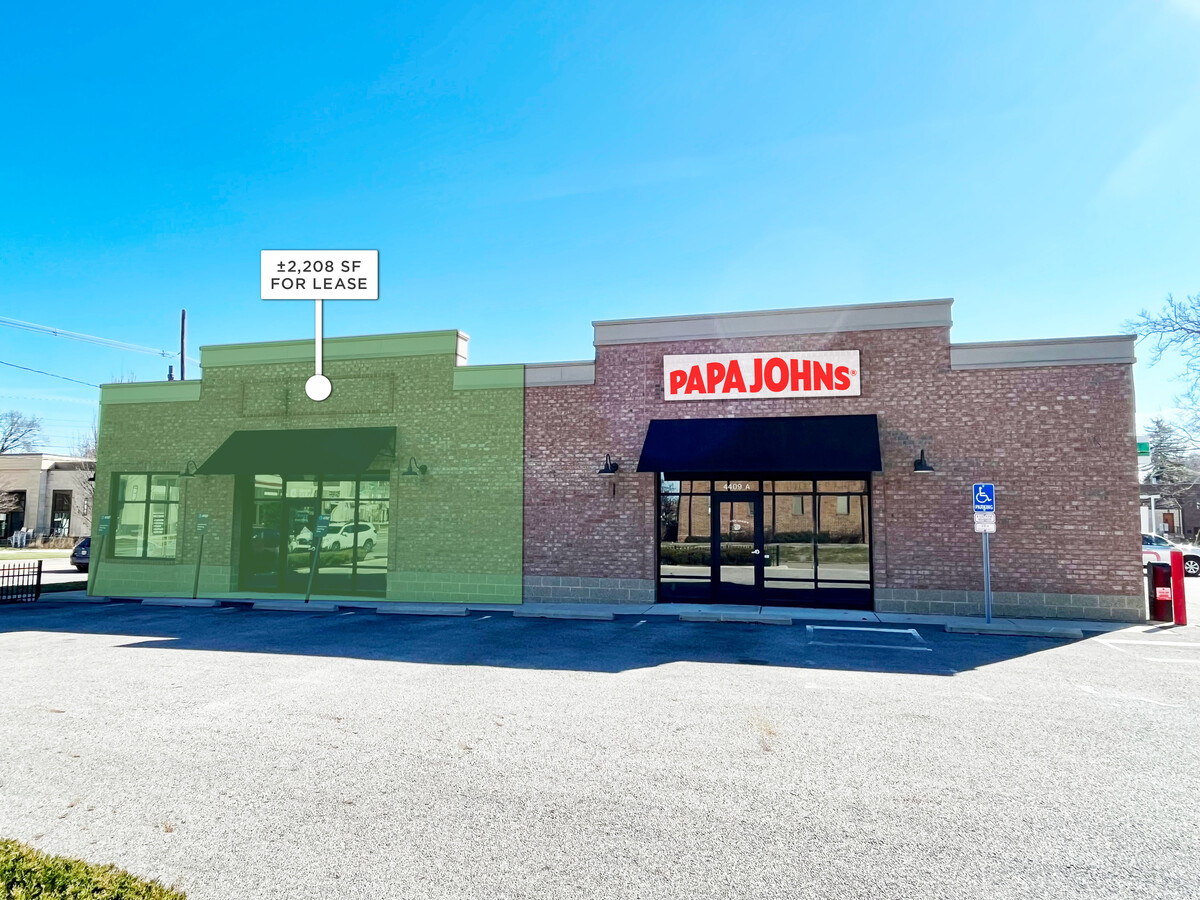
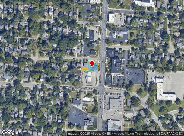
Property Record
4409 N High St, Columbus, OH 43214
NEARBY LISTINGS FOR SALE OR LEASE
Property Detail
4409 N High St
Columbus, OH
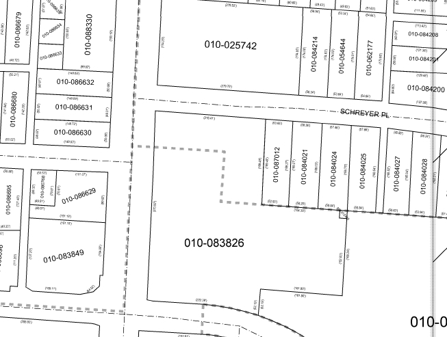
Rosemary Addition
010-086629
ROSEMARY PT LOTS 4 & 5 EX IRR NE COR
Storebuilding
Franklin
X
Ohio
39049C0167K
4-5
2023
0.26 AC
2023
North Central
000120
Columbus
3,478 SF
DEMOGRAPHICS near 4409 N High St
1 Mile
3 Mile
5 Mile
2024 Total Population
11,086
124,999
366,656
2029 Population
11,030
124,714
366,569
Pop Growth 2024-2029
(0.51%)
(0.23%)
(0.02%)
Average Age
44
39
36
2024 Total Households
5,466
56,533
152,843
HH Growth 2024-2029
(0.49%)
(0.19%)
(0.04%)
Median Household Inc
$95,848
$65,382
$61,143
Avg Household Size
2.00
2.20
2.20
2024 Avg HH Vehicles
2.00
2.00
2.00
Median Home Value
$343,760
$285,809
$285,205
Median Year Built
1952
1962
1969
Nearby Places
- Restaurants
- Banks
- Shops
- Fitness
- Groceries
PUBLIC TRANSPORTATION
AIRPORT
John Glenn Columbus International
DRIVE
WALK
Distance
John Glenn Columbus International
20 min
12.2 mi
Rickenbacker International
DRIVE
WALK
Distance
Rickenbacker International
33 min
21.3 mi
Freight Ports
Port of Toledo
DRIVE
WALK
Distance
Port of Toledo
175 min
138.1 mi
SALE & LEASE HISTORY
LISTING DATE
SALE/LEASE

May 14, 2019
For Sale
Jun 09, 2017
For Lease
Jun 05, 2023
For Lease
Feb 22, 2018
For Lease
Aug 08, 2018
For Lease
Apr 03, 2020
For Sale
Nearby Properties
Address
Land Use
TOTAL SIZE
Lot Size
Zoning
Address
Land Use
TOTAL SIZE
Lot Size
Zoning
3,462,019 SF
54.42 AC
Address
Land Use
TOTAL SIZE
Lot Size
Zoning
344,620 SF
296.23 AC
Address
Land Use
TOTAL SIZE
Lot Size
Zoning
378,522 SF
41.13 AC
Address
Land Use
TOTAL SIZE
Lot Size
Zoning
720,432 SF
45.78 AC
Address
Land Use
TOTAL SIZE
Lot Size
Zoning
383,533 SF
84.68 AC
Address
Land Use
TOTAL SIZE
Lot Size
Zoning
1,034,007 SF
8.45 AC
Address
Land Use
TOTAL SIZE
Lot Size
Zoning
967,995 SF
11.72 AC
Address
Land Use
TOTAL SIZE
Lot Size
Zoning
703,512 SF
5.40 AC
Address
Land Use
TOTAL SIZE
Lot Size
Zoning
561,921 SF
6.81 AC
Address
Land Use
TOTAL SIZE
Lot Size
Zoning
286,169 SF
11.08 AC
Address
Land Use
TOTAL SIZE
Lot Size
Zoning
438,301 SF
26.10 AC
Address
Land Use
TOTAL SIZE
Lot Size
Zoning
796,023 SF
19.35 AC
Address
Land Use
TOTAL SIZE
Lot Size
Zoning
820,734 SF
0.94 AC
Address
Land Use
TOTAL SIZE
Lot Size
Zoning
425,872 SF
10.05 AC
Address
Land Use
TOTAL SIZE
Lot Size
Zoning
733,806 SF
27.30 AC
Address
Land Use
TOTAL SIZE
Lot Size
Zoning
Address
Land Use
TOTAL SIZE
Lot Size
Zoning
762,177 SF
6.94 AC
Address
Land Use
TOTAL SIZE
Lot Size
Zoning
1,191,579 SF
20.74 AC
Address
Land Use
TOTAL SIZE
Lot Size
Zoning
273,112 SF
13.97 AC
Address
Land Use
TOTAL SIZE
Lot Size
Zoning
167,550 SF
36.79 AC
Address
Land Use
TOTAL SIZE
Lot Size
Zoning
171,832 SF
17.77 AC
Address
Land Use
TOTAL SIZE
Lot Size
Zoning
170,237 SF
97.38 AC
Address
Land Use
TOTAL SIZE
Lot Size
Zoning
1,074,792 SF
10.88 AC
Address
Land Use
TOTAL SIZE
Lot Size
Zoning
157,919 SF
13.18 AC
Address
Land Use
TOTAL SIZE
Lot Size
Zoning
451,404 SF
24.57 AC
Address
Land Use
TOTAL SIZE
Lot Size
Zoning
138,100 SF
8.38 AC
Address
Land Use
TOTAL SIZE
Lot Size
Zoning
131,040 SF
2.50 AC
Address
Land Use
TOTAL SIZE
Lot Size
Zoning
352,730 SF
17.94 AC
Address
Land Use
TOTAL SIZE
Lot Size
Zoning
561,675 SF
10.28 AC
Address
Land Use
TOTAL SIZE
Lot Size
Zoning
436,158 SF
16.24 AC
The World's #1 Commercial Real Estate Marketplace
Connect with us
© 2025 CoStar Group
The information above has been obtained from sources believed reliable. While we do not doubt its accuracy we have not verified it and make no guarantee, warranty or representation about it. It is your responsibility to independently confirm its accuracy and completeness. Any projections, opinions, assumptions, or estimates used are for example only and do not represent the current or future performance of the property. The value of this transaction to you depends on tax and other factors which should be evaluated by your tax, financial, and legal advisors. You and your advisors should conduct a careful, independent investigation of the property to determine to your satisfaction the suitability of the property for your needs.