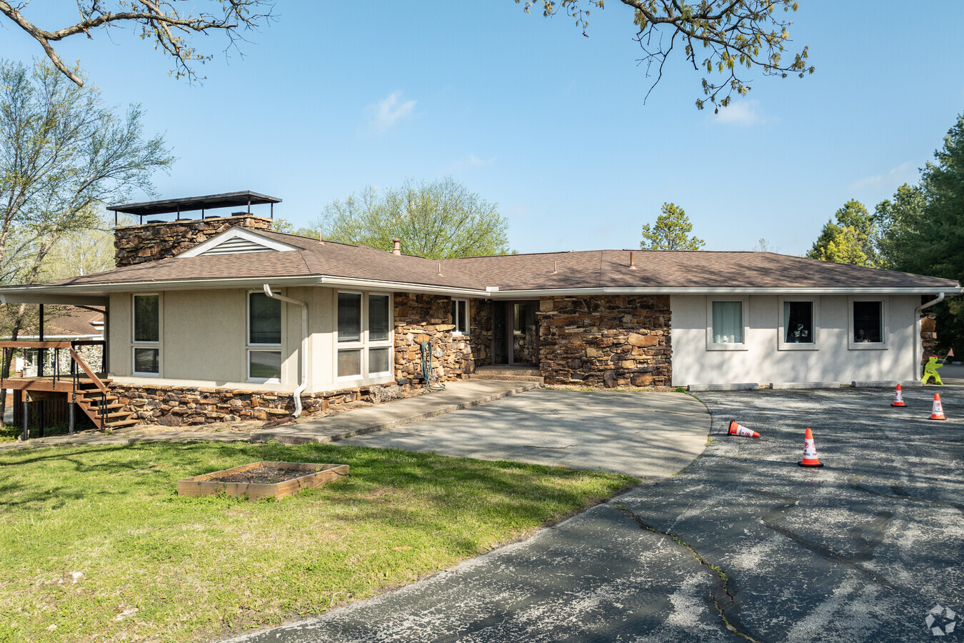
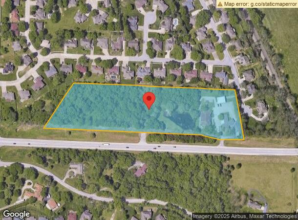
Property Record
4411 E State Highway D, Springfield, MO 65809

Current Lease Availabilities
NEARBY LISTINGS FOR SALE OR LEASE
Property Detail
4411 E State Highway D
12-26-300-129
M/L BEG ON NLY R/W HWY D 249.55 FT E NW COR 26/29/21 E 1346. 1 FT M/L NWLY 383.96FT W 1033.1 FT SWLY 437.76 FT TO BEG
Officebuilding
Greene
X
Missouri
29077C0362E
7.55 AC
2024
Northeast
2024
Springfield
003701
Springfield, MO
10,300 SF
DEMOGRAPHICS near 4411 E State Highway D
1 Mile
3 Mile
5 Mile
2024 Total Population
3,953
32,258
85,508
2029 Population
4,106
33,393
88,591
Pop Growth 2024-2029
+ 3.87%
+ 3.52%
+ 3.61%
Average Age
45
42
40
2024 Total Households
1,538
14,063
37,822
HH Growth 2024-2029
+ 4.10%
+ 3.72%
+ 3.83%
Median Household Inc
$121,821
$66,380
$53,414
Avg Household Size
2.60
2.20
2.10
2024 Avg HH Vehicles
2.00
2.00
2.00
Median Home Value
$331,589
$250,502
$206,839
Median Year Built
1988
1979
1976
Nearby Places
- Restaurants
- Banks
- Shops
- Fitness
- Groceries
PUBLIC TRANSPORTATION
AIRPORT
Springfield-Branson Ntl
DRIVE
WALK
Distance
Springfield-Branson Ntl
29 min
19.0 mi
Freight Ports
Tulsa Port of Inola
DRIVE
WALK
Distance
Tulsa Port of Inola
202 min
180.6 mi
Nearby Properties
Address
Land Use
TOTAL SIZE
Lot Size
Zoning
Address
Land Use
TOTAL SIZE
Lot Size
Zoning
162,468 SF
35.77 AC
INC
Address
Land Use
TOTAL SIZE
Lot Size
Zoning
18.35 AC
Address
Land Use
TOTAL SIZE
Lot Size
Zoning
10.29 AC
INC.
Address
Land Use
TOTAL SIZE
Lot Size
Zoning
4.63 AC
O-2
Address
Land Use
TOTAL SIZE
Lot Size
Zoning
779,221 SF
45.03 AC
INC
Address
Land Use
TOTAL SIZE
Lot Size
Zoning
17.07 AC
INC.
Address
Land Use
TOTAL SIZE
Lot Size
Zoning
25.51 AC
INC
Address
Land Use
TOTAL SIZE
Lot Size
Zoning
324,341 SF
43 AC
INC
Address
Land Use
TOTAL SIZE
Lot Size
Zoning
2 AC
INC.
Address
Land Use
TOTAL SIZE
Lot Size
Zoning
26,240 SF
2.39 AC
INC.
Address
Land Use
TOTAL SIZE
Lot Size
Zoning
2.69 AC
INC
Address
Land Use
TOTAL SIZE
Lot Size
Zoning
323,771 SF
31.48 AC
INC
Address
Land Use
TOTAL SIZE
Lot Size
Zoning
66,686 SF
1.91 AC
INC
Address
Land Use
TOTAL SIZE
Lot Size
Zoning
2.96 AC
INC.
Address
Land Use
TOTAL SIZE
Lot Size
Zoning
91,885 SF
13.29 AC
INC
Address
Land Use
TOTAL SIZE
Lot Size
Zoning
1.44 AC
INC
Address
Land Use
TOTAL SIZE
Lot Size
Zoning
48,139 SF
5.75 AC
INC
Address
Land Use
TOTAL SIZE
Lot Size
Zoning
162,312 SF
7.84 AC
INC
Address
Land Use
TOTAL SIZE
Lot Size
Zoning
7.32 AC
INC
Address
Land Use
TOTAL SIZE
Lot Size
Zoning
115,860 SF
9.18 AC
INC
Address
Land Use
TOTAL SIZE
Lot Size
Zoning
16.98 AC
INC
Address
Land Use
TOTAL SIZE
Lot Size
Zoning
2.32 AC
INC
Address
Land Use
TOTAL SIZE
Lot Size
Zoning
240,098 SF
12.33 AC
INC
Address
Land Use
TOTAL SIZE
Lot Size
Zoning
Address
Land Use
TOTAL SIZE
Lot Size
Zoning
5.98 AC
INC
Address
Land Use
TOTAL SIZE
Lot Size
Zoning
47,183 SF
12.33 AC
INC
Address
Land Use
TOTAL SIZE
Lot Size
Zoning
77,930 SF
8.60 AC
INC
Address
Land Use
TOTAL SIZE
Lot Size
Zoning
4.23 AC
PAD
Address
Land Use
TOTAL SIZE
Lot Size
Zoning
107,280 SF
7.75 AC
INC
Address
Land Use
TOTAL SIZE
Lot Size
Zoning
65,867 SF
127 AC
INC
The World's #1 Commercial Real Estate Marketplace
Connect with us
© 2025 CoStar Group
The information above has been obtained from sources believed reliable. While we do not doubt its accuracy we have not verified it and make no guarantee, warranty or representation about it. It is your responsibility to independently confirm its accuracy and completeness. Any projections, opinions, assumptions, or estimates used are for example only and do not represent the current or future performance of the property. The value of this transaction to you depends on tax and other factors which should be evaluated by your tax, financial, and legal advisors. You and your advisors should conduct a careful, independent investigation of the property to determine to your satisfaction the suitability of the property for your needs.