Property Record
4439 S Buttermilk Ct, Hudsonville, MI 49426
Current Lease Availabilities
NEARBY LISTINGS FOR SALE OR LEASE
-
-
View all Hudsonville listings for lease on LoopNet.com
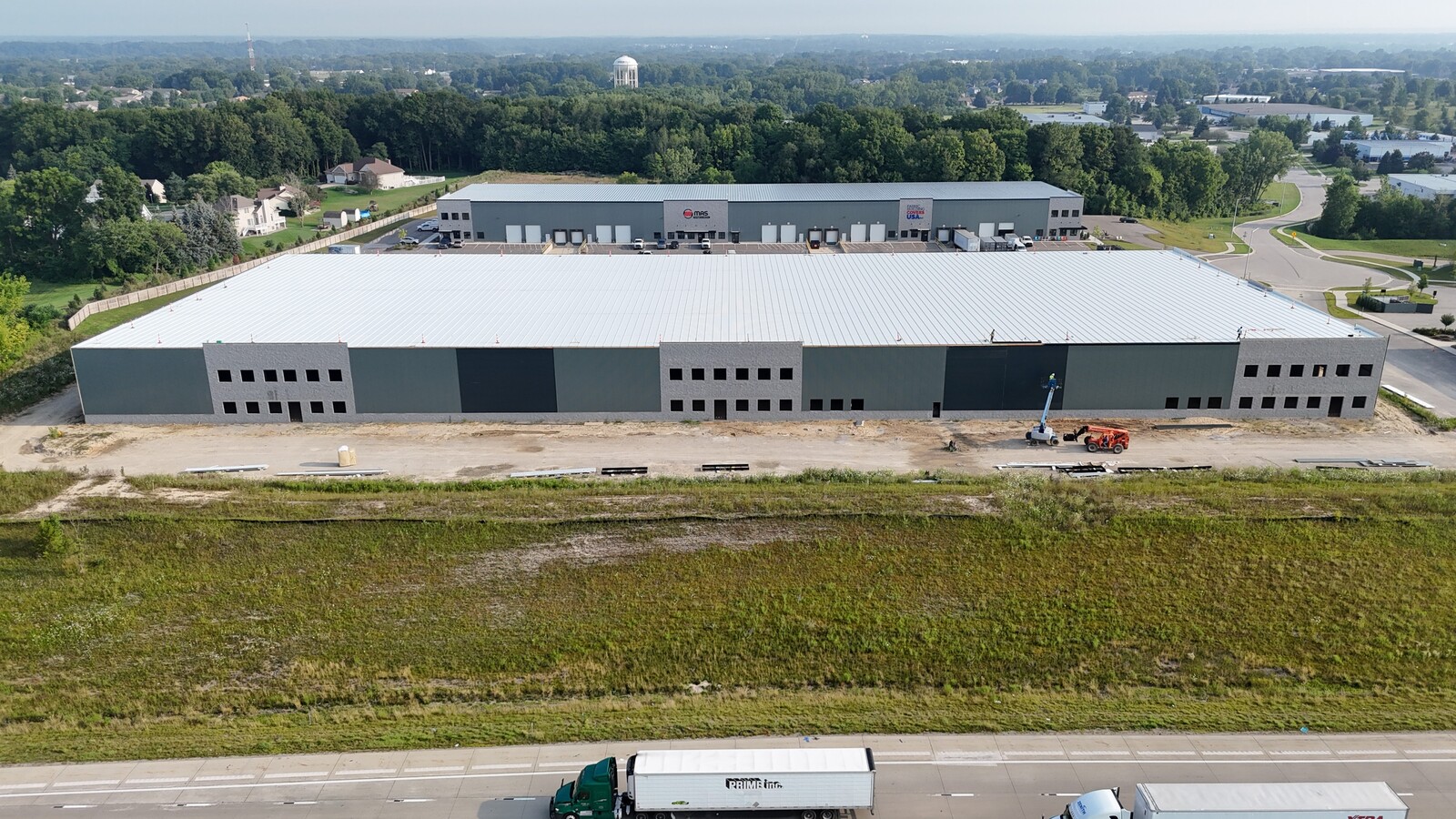
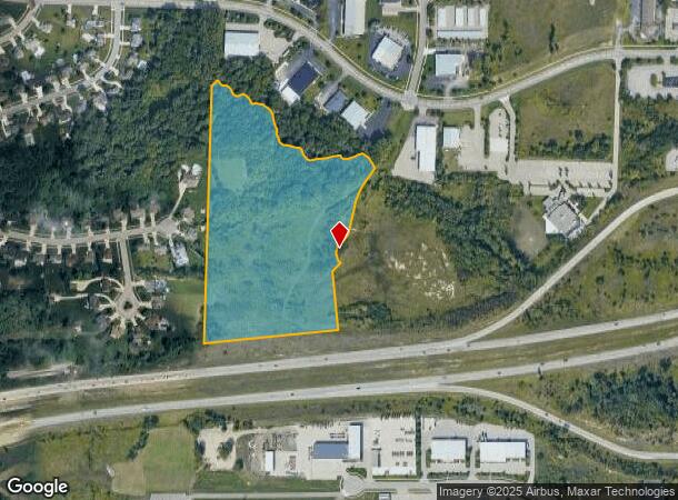
Property Detail
4439 S Buttermilk Ct
Grand Rapids-Wyoming, MI
Creek Commerce Park Plat
70-18-05-201-052
PART OF NE 1/4 COM N 1/4 COR, TH S 1D 21M 38S W 158657 FT TO PT OF BEG, TH CONT S 1D 21M 38S W 1300 FT, N 83D 55M 28S E 70129
Publicstorage
Ottawa
X
Michigan
26139C0351E
5,8
2023
18.36 AC
2024
E Ottawa Cnty/Hudsonville
021801
West Michigan
60,000 SF
DEMOGRAPHICS near 4439 S Buttermilk Ct
1 Mile
3 Mile
5 Mile
2024 Total Population
3,296
24,063
63,515
2029 Population
3,480
25,359
66,657
Pop Growth 2024-2029
+ 5.58%
+ 5.39%
+ 4.95%
Average Age
38
36
38
2024 Total Households
1,222
8,183
21,830
HH Growth 2024-2029
+ 5.65%
+ 5.45%
+ 5.03%
Median Household Inc
$85,625
$94,476
$91,634
Avg Household Size
2.70
2.90
2.90
2024 Avg HH Vehicles
2.00
2.00
2.00
Median Home Value
$273,993
$279,349
$275,249
Median Year Built
1995
1998
1990
Nearby Places
- Restaurants
- Banks
- Shops
- Fitness
- Groceries
PUBLIC TRANSPORTATION
AIRPORT
Gerald R Ford International
DRIVE
WALK
Distance
Gerald R Ford International
31 min
21.1 mi
Freight Ports
Port Milwaukee
DRIVE
WALK
Distance
Port Milwaukee
291 min
248.9 mi
Nearby Properties
Address
Land Use
TOTAL SIZE
Lot Size
Zoning
Address
Land Use
TOTAL SIZE
Lot Size
Zoning
196,665 SF
46.39 AC
SEE MAP
Address
Land Use
TOTAL SIZE
Lot Size
Zoning
273,515 SF
Address
Land Use
TOTAL SIZE
Lot Size
Zoning
20.60 AC
HDR
Address
Land Use
TOTAL SIZE
Lot Size
Zoning
22.23 AC
R-4
Address
Land Use
TOTAL SIZE
Lot Size
Zoning
74.03 AC
MHP
Address
Land Use
TOTAL SIZE
Lot Size
Zoning
138,648 SF
Address
Land Use
TOTAL SIZE
Lot Size
Zoning
322,519 SF
27.04 AC
IND-G
Address
Land Use
TOTAL SIZE
Lot Size
Zoning
83,640 SF
R-1-A
Address
Land Use
TOTAL SIZE
Lot Size
Zoning
85,799 SF
12.89 AC
SEE MAP
Address
Land Use
TOTAL SIZE
Lot Size
Zoning
124,950 SF
18.30 AC
MHR
Address
Land Use
TOTAL SIZE
Lot Size
Zoning
66,766 SF
R-1-A
Address
Land Use
TOTAL SIZE
Lot Size
Zoning
162,719 SF
19.76 AC
SEE MAP
Address
Land Use
TOTAL SIZE
Lot Size
Zoning
392,381 SF
21.73 AC
SEE MAP
Address
Land Use
TOTAL SIZE
Lot Size
Zoning
121,265 SF
17.97 AC
I-2
Address
Land Use
TOTAL SIZE
Lot Size
Zoning
139,774 SF
10.67 AC
HDR-B
Address
Land Use
TOTAL SIZE
Lot Size
Zoning
8,464 SF
80.47 AC
SEE MAP
Address
Land Use
TOTAL SIZE
Lot Size
Zoning
56,784 SF
7.93 AC
R-4
Address
Land Use
TOTAL SIZE
Lot Size
Zoning
78,846 SF
8.73 AC
I
Address
Land Use
TOTAL SIZE
Lot Size
Zoning
47,386 SF
6.93 AC
LDR
Address
Land Use
TOTAL SIZE
Lot Size
Zoning
11.56 AC
SEE MAP
Address
Land Use
TOTAL SIZE
Lot Size
Zoning
6.29 AC
SEE MAP
Address
Land Use
TOTAL SIZE
Lot Size
Zoning
78,392 SF
10.45 AC
I-2
Address
Land Use
TOTAL SIZE
Lot Size
Zoning
91,450 SF
10.45 AC
SEE MAP
Address
Land Use
TOTAL SIZE
Lot Size
Zoning
44,400 SF
6.69 AC
HS
Address
Land Use
TOTAL SIZE
Lot Size
Zoning
103,976 SF
8.68 AC
IND-G
Address
Land Use
TOTAL SIZE
Lot Size
Zoning
38,017 SF
5.46 AC
HC
Address
Land Use
TOTAL SIZE
Lot Size
Zoning
32,400 SF
67.30 AC
SEE MAP
Address
Land Use
TOTAL SIZE
Lot Size
Zoning
94,894 SF
7.35 AC
I
Address
Land Use
TOTAL SIZE
Lot Size
Zoning
42,914 SF
4.04 AC
SEE MAP
The World's #1 Commercial Real Estate Marketplace
Connect with us
© 2025 CoStar Group
The information above has been obtained from sources believed reliable. While we do not doubt its accuracy we have not verified it and make no guarantee, warranty or representation about it. It is your responsibility to independently confirm its accuracy and completeness. Any projections, opinions, assumptions, or estimates used are for example only and do not represent the current or future performance of the property. The value of this transaction to you depends on tax and other factors which should be evaluated by your tax, financial, and legal advisors. You and your advisors should conduct a careful, independent investigation of the property to determine to your satisfaction the suitability of the property for your needs.