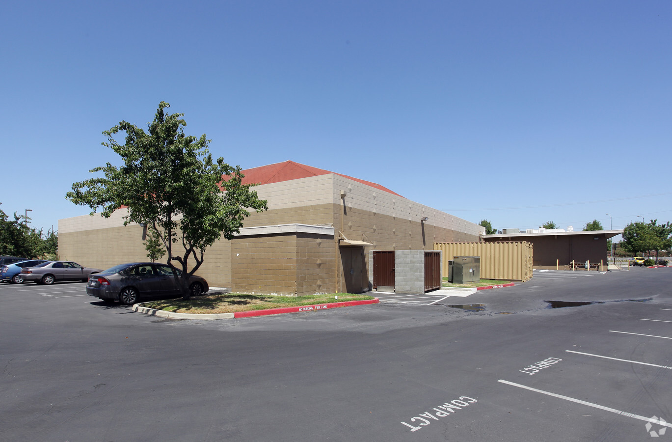
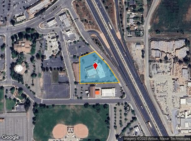
Property Record
446 Fairway Dr, Galt, CA 95632

NEARBY LISTINGS FOR SALE OR LEASE
Property Detail
446 Fairway Dr
Sacramento--Roseville--Arden-Arcade, CA
Baumbach Tract
150-0303-062
LOT 14, BAUMBACH TRACT, EXC POR DEEDED TO THE CITY OF GALT FOR R/W PURPOSES PER GRANT DEED BK 20100319 BK1155
Religious
Sacramento
X
California
06067C0468J
14
0
1.94 AC
2024
Outer Sacramento Cnty
009504
Sacramento
17,264 SF
DEMOGRAPHICS near 446 Fairway Dr
1 Mile
3 Mile
5 Mile
2024 Total Population
7,156
29,657
31,927
2029 Population
7,209
29,747
32,005
Pop Growth 2024-2029
+ 0.74%
+ 0.30%
+ 0.24%
Average Age
38
39
39
2024 Total Households
2,292
9,490
10,224
HH Growth 2024-2029
+ 0.65%
+ 0.26%
+ 0.22%
Median Household Inc
$61,313
$84,927
$85,773
Avg Household Size
3.10
3.10
3.10
2024 Avg HH Vehicles
2.00
2.00
2.00
Median Home Value
$388,797
$456,473
$464,148
Median Year Built
1980
1992
1991
Nearby Places
- Restaurants
- Banks
- Shops
- Fitness
- Groceries
PUBLIC TRANSPORTATION
COMMUTER RAIL
Lodi Amtrak Station (San Joaquins - Amtrak)
DRIVE
WALK
Distance
Lodi Amtrak Station (San Joaquins - Amtrak)
14 min
9.6 mi
AIRPORT
Stockton Metro
DRIVE
WALK
Distance
Stockton Metro
36 min
28.0 mi
Freight Ports
Port of Stockton
DRIVE
WALK
Distance
Port of Stockton
35 min
26.5 mi
Nearby Properties
Address
Land Use
TOTAL SIZE
Lot Size
Zoning
Address
Land Use
TOTAL SIZE
Lot Size
Zoning
284,700 SF
19.12 AC
LM
Address
Land Use
TOTAL SIZE
Lot Size
Zoning
223,974 SF
12.06 AC
LM
Address
Land Use
TOTAL SIZE
Lot Size
Zoning
127,249 SF
11.18 AC
HC
Address
Land Use
TOTAL SIZE
Lot Size
Zoning
17.58 AC
R4
Address
Land Use
TOTAL SIZE
Lot Size
Zoning
65,200 SF
5.04 AC
HC
Address
Land Use
TOTAL SIZE
Lot Size
Zoning
77,052 SF
0.93 AC
DC
Address
Land Use
TOTAL SIZE
Lot Size
Zoning
0.99 AC
HC
Address
Land Use
TOTAL SIZE
Lot Size
Zoning
95,616 SF
8.42 AC
R3
Address
Land Use
TOTAL SIZE
Lot Size
Zoning
46,376 SF
4.18 AC
C
Address
Land Use
TOTAL SIZE
Lot Size
Zoning
4,986 SF
1.62 AC
HC
Address
Land Use
TOTAL SIZE
Lot Size
Zoning
52,000 SF
3.28 AC
C
Address
Land Use
TOTAL SIZE
Lot Size
Zoning
67,312 SF
10.20 AC
LM
Address
Land Use
TOTAL SIZE
Lot Size
Zoning
102,790 SF
6.29 AC
LM
Address
Land Use
TOTAL SIZE
Lot Size
Zoning
18,089 SF
10.36 AC
LM
Address
Land Use
TOTAL SIZE
Lot Size
Zoning
21,304 SF
2.91 AC
C
Address
Land Use
TOTAL SIZE
Lot Size
Zoning
1.53 AC
LM
Address
Land Use
TOTAL SIZE
Lot Size
Zoning
259.50 AC
AG-80
Address
Land Use
TOTAL SIZE
Lot Size
Zoning
47,710 SF
2.60 AC
R4
Address
Land Use
TOTAL SIZE
Lot Size
Zoning
17,340 SF
1.80 AC
C
Address
Land Use
TOTAL SIZE
Lot Size
Zoning
1,986 SF
5 AC
R3
Address
Land Use
TOTAL SIZE
Lot Size
Zoning
760 SF
8.35 AC
LM
Address
Land Use
TOTAL SIZE
Lot Size
Zoning
32,567 SF
6.27 AC
R3
Address
Land Use
TOTAL SIZE
Lot Size
Zoning
50,732 SF
6.19 AC
R2
Address
Land Use
TOTAL SIZE
Lot Size
Zoning
8,844 SF
6.16 AC
OP
Address
Land Use
TOTAL SIZE
Lot Size
Zoning
12,804 SF
9.89 AC
PQ
Address
Land Use
TOTAL SIZE
Lot Size
Zoning
43,000 SF
1.90 AC
HC
Address
Land Use
TOTAL SIZE
Lot Size
Zoning
64,868 SF
3.69 AC
LM
Address
Land Use
TOTAL SIZE
Lot Size
Zoning
58 AC
OS R1C
Address
Land Use
TOTAL SIZE
Lot Size
Zoning
32,196 SF
2.89 AC
C
Address
Land Use
TOTAL SIZE
Lot Size
Zoning
80,666 SF
10.48 AC
LM
The World's #1 Commercial Real Estate Marketplace
Connect with us
© 2025 CoStar Group
The information above has been obtained from sources believed reliable. While we do not doubt its accuracy we have not verified it and make no guarantee, warranty or representation about it. It is your responsibility to independently confirm its accuracy and completeness. Any projections, opinions, assumptions, or estimates used are for example only and do not represent the current or future performance of the property. The value of this transaction to you depends on tax and other factors which should be evaluated by your tax, financial, and legal advisors. You and your advisors should conduct a careful, independent investigation of the property to determine to your satisfaction the suitability of the property for your needs.