Property Record
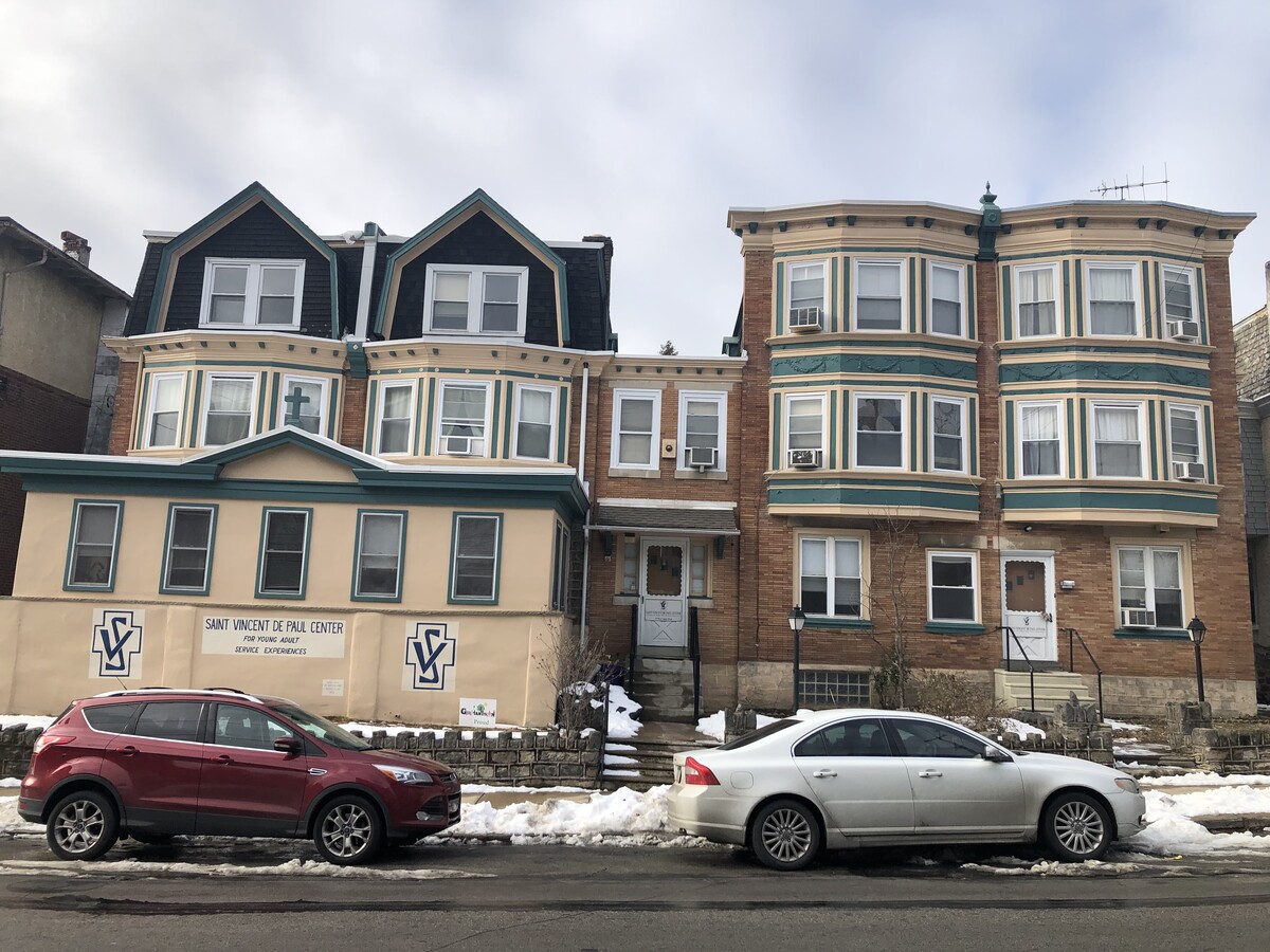
45 W Logan St, Philadelphia, PA 19144


This Property Is For Sale
NEARBY LISTINGS FOR SALE OR LEASE
Property Detail
45 W Logan St
776194000
43'6 1/2" W ROYAL ST
Religious
Philadelphia
X
Pennsylvania
42091C0395G
92
2022
0.18 AC
2025
Northwest Philadelphia
024400
Philadelphia
9,482 SF
Philadelphia-Camden-Wilmington, PA-NJ-DE-MD
DEMOGRAPHICS near 45 W Logan St
1 Mile
3 Mile
5 Mile
2024 Total Population
41,140
373,533
864,591
2029 Population
40,280
363,029
845,620
Pop Growth 2024-2029
(2.09%)
(2.81%)
(2.19%)
Average Age
39
39
38
2024 Total Households
17,088
150,043
348,978
HH Growth 2024-2029
(2.33%)
(2.95%)
(2.32%)
Median Household Inc
$36,754
$40,645
$51,099
Avg Household Size
2.20
2.30
2.30
2024 Avg HH Vehicles
1.00
1.00
1.00
Median Home Value
$162,518
$159,867
$213,449
Median Year Built
1947
1947
1949
Nearby Places
- Restaurants
- Banks
- Shops
- Fitness
- Groceries
PUBLIC TRANSPORTATION
TRANSIT/SUBWAY
Logan (Broad Street Line - Southeastern Pennsylvania Transportation Authority Rapid Transit (SEPTA Subway & Trolley))
DRIVE
WALK
Distance
Logan (Broad Street Line - Southeastern Pennsylvania Transportation Authority Rapid Transit (SEPTA Subway & Trolley))
4 min
20 min
1.1 mi
COMMUTER RAIL
Wayne Junction (R1 - Southeastern Pennsylvania Transportation Authority Regional Rail (SEPTA Regional Rail), R2 - Southeastern Pennsylvania Transportation Authority Regional Rail (SEPTA Regional Rail), R3 - Southeastern Pennsylvania Transportation Authority Regional Rail (SEPTA Regional Rail), R5 - Southeastern Pennsylvania Transportation Authority Regional Rail (SEPTA Regional Rail), R7 - Southeastern Pennsylvania Transportation Authority Regional Rail (SEPTA Regional Rail), R8 - Southeastern Pennsylvania Transportation Authority Regional Rail (SEPTA Regional Rail))
DRIVE
WALK
Distance
Wayne Junction (R1 - Southeastern Pennsylvania Transportation Authority Regional Rail (SEPTA Regional Rail), R2 - Southeastern Pennsylvania Transportation Authority Regional Rail (SEPTA Regional Rail), R3 - Southeastern Pennsylvania Transportation Authority Regional Rail (SEPTA Regional Rail), R5 - Southeastern Pennsylvania Transportation Authority Regional Rail (SEPTA Regional Rail), R7 - Southeastern Pennsylvania Transportation Authority Regional Rail (SEPTA Regional Rail), R8 - Southeastern Pennsylvania Transportation Authority Regional Rail (SEPTA Regional Rail))
1 min
9 min
0.5 mi
Wister (R7 - Southeastern Pennsylvania Transportation Authority Regional Rail (SEPTA Regional Rail))
DRIVE
WALK
Distance
Wister (R7 - Southeastern Pennsylvania Transportation Authority Regional Rail (SEPTA Regional Rail))
4 min
17 min
0.9 mi
AIRPORT
Philadelphia International
DRIVE
WALK
Distance
Philadelphia International
29 min
16.3 mi
Trenton Mercer
DRIVE
WALK
Distance
Trenton Mercer
52 min
30.2 mi
Freight Ports
Port of Philadelphia
DRIVE
WALK
Distance
Port of Philadelphia
14 min
6.9 mi
Nearby Properties
Address
Land Use
TOTAL SIZE
Lot Size
Zoning
Address
Land Use
TOTAL SIZE
Lot Size
Zoning
391,885 SF
7.15 AC
RM4
Address
Land Use
TOTAL SIZE
Lot Size
Zoning
455,889 SF
33 AC
I2
Address
Land Use
TOTAL SIZE
Lot Size
Zoning
520,280 SF
14.84 AC
RM3
Address
Land Use
TOTAL SIZE
Lot Size
Zoning
438,228 SF
38.69 AC
RM3
Address
Land Use
TOTAL SIZE
Lot Size
Zoning
485,616 SF
8.96 AC
CMX3
Address
Land Use
TOTAL SIZE
Lot Size
Zoning
242,655 SF
3.29 AC
CMX3
Address
Land Use
TOTAL SIZE
Lot Size
Zoning
451,857 SF
3.57 AC
CMX2
Address
Land Use
TOTAL SIZE
Lot Size
Zoning
425,535 SF
4.60 AC
RM3
Address
Land Use
TOTAL SIZE
Lot Size
Zoning
760,200 SF
10.90 AC
RM2
Address
Land Use
TOTAL SIZE
Lot Size
Zoning
3,590 SF
50 AC
SPPOA
Address
Land Use
TOTAL SIZE
Lot Size
Zoning
121,578 SF
3.13 AC
RSA3
Address
Land Use
TOTAL SIZE
Lot Size
Zoning
587,330 SF
34.37 AC
SPINS
Address
Land Use
TOTAL SIZE
Lot Size
Zoning
287,286 SF
1.26 AC
CMX5
Address
Land Use
TOTAL SIZE
Lot Size
Zoning
3,317,508 SF
20.06 AC
CMX2
Address
Land Use
TOTAL SIZE
Lot Size
Zoning
17,886 SF
80 AC
SPPOA
Address
Land Use
TOTAL SIZE
Lot Size
Zoning
164,412 SF
4.44 AC
SPINS
Address
Land Use
TOTAL SIZE
Lot Size
Zoning
418,017 SF
19.10 AC
CO
Address
Land Use
TOTAL SIZE
Lot Size
Zoning
495,017 SF
9.65 AC
CMX3
Address
Land Use
TOTAL SIZE
Lot Size
Zoning
388,608 SF
9.33 AC
RM2
Address
Land Use
TOTAL SIZE
Lot Size
Zoning
210,738 SF
8.73 AC
RM4
Address
Land Use
TOTAL SIZE
Lot Size
Zoning
504,972 SF
16.30 AC
RM2
Address
Land Use
TOTAL SIZE
Lot Size
Zoning
500,000 SF
2.30 AC
CMX3
Address
Land Use
TOTAL SIZE
Lot Size
Zoning
218,030 SF
23.75 AC
CA2
Address
Land Use
TOTAL SIZE
Lot Size
Zoning
180,750 SF
1.60 AC
CMX3
Address
Land Use
TOTAL SIZE
Lot Size
Zoning
178,738 SF
6.11 AC
CMX3
Address
Land Use
TOTAL SIZE
Lot Size
Zoning
238,378 SF
18 AC
CA1
Address
Land Use
TOTAL SIZE
Lot Size
Zoning
235,276 SF
1.88 AC
CMX2.5
Address
Land Use
TOTAL SIZE
Lot Size
Zoning
561,600 SF
11.28 AC
CMX3
Address
Land Use
TOTAL SIZE
Lot Size
Zoning
3,356,100 SF
5.28 AC
RM4
Address
Land Use
TOTAL SIZE
Lot Size
Zoning
75,358 SF
24.98 AC
I2
The World's #1 Commercial Real Estate Marketplace
Connect with us
© 2025 CoStar Group
The information above has been obtained from sources believed reliable. While we do not doubt its accuracy we have not verified it and make no guarantee, warranty or representation about it. It is your responsibility to independently confirm its accuracy and completeness. Any projections, opinions, assumptions, or estimates used are for example only and do not represent the current or future performance of the property. The value of this transaction to you depends on tax and other factors which should be evaluated by your tax, financial, and legal advisors. You and your advisors should conduct a careful, independent investigation of the property to determine to your satisfaction the suitability of the property for your needs.