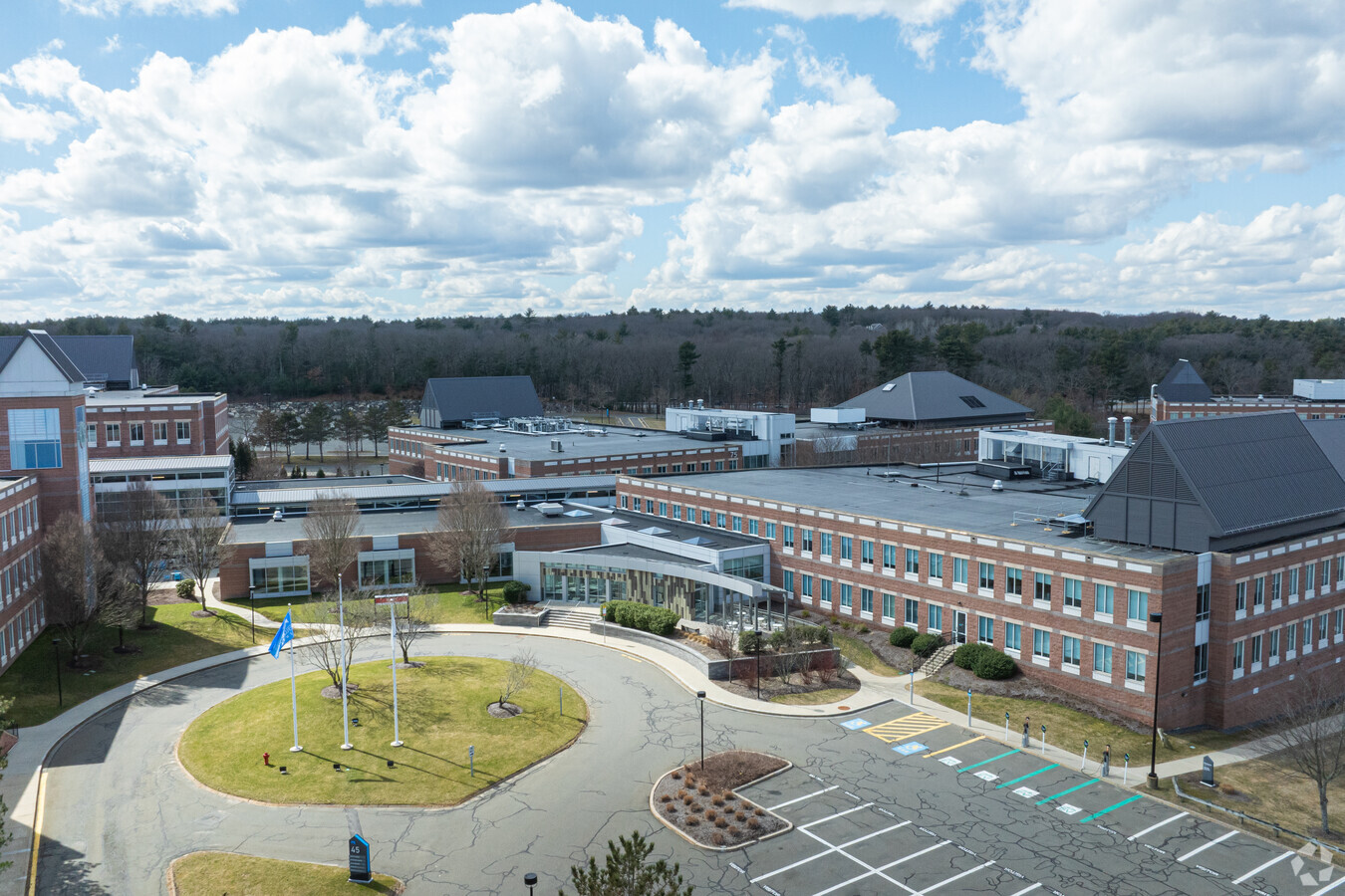
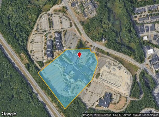
Property Record
45 Blue Sky Dr, Burlington, MA 01803

Current Lease Availabilities
NEARBY LISTINGS FOR SALE OR LEASE
Property Detail
45 Blue Sky Dr
BURL-000032-000000-000003
Middlesex
Commercialnec
Massachusetts
AE
23.55 AC
25017C0401E
Burlington/Woburn
2020
Boston
2024
Boston-Cambridge-Newton, MA-NH
332402
DEMOGRAPHICS near 45 Blue Sky Dr
1 Mile
3 Mile
5 Mile
2024 Total Population
4,944
53,308
146,121
2029 Population
4,889
52,916
144,929
Pop Growth 2024-2029
(1.11%)
(0.74%)
(0.82%)
Average Age
41
43
42
2024 Total Households
1,922
19,256
53,504
HH Growth 2024-2029
(1.46%)
(0.77%)
(0.89%)
Median Household Inc
$119,548
$144,199
$136,149
Avg Household Size
2.50
2.70
2.70
2024 Avg HH Vehicles
2.00
2.00
2.00
Median Home Value
$781,377
$770,163
$749,069
Median Year Built
1975
1969
1969
Nearby Places
- Restaurants
- Banks
- Shops
- Fitness
- Groceries
PUBLIC TRANSPORTATION
COMMUTER RAIL
Anderson/Woburn Regional Transportation Center (Lowell Line - Massachusetts Bay Transportation Authority Commuter Rail (Purple Line))
DRIVE
WALK
Distance
Anderson/Woburn Regional Transportation Center (Lowell Line - Massachusetts Bay Transportation Authority Commuter Rail (Purple Line))
13 min
5.9 mi
Wilmington (Lowell Line - Massachusetts Bay Transportation Authority Commuter Rail (Purple Line))
DRIVE
WALK
Distance
Wilmington (Lowell Line - Massachusetts Bay Transportation Authority Commuter Rail (Purple Line))
13 min
6.1 mi
AIRPORT
General Edward Lawrence Logan International
DRIVE
WALK
Distance
General Edward Lawrence Logan International
32 min
17.4 mi
Freight Ports
Port of Boston
DRIVE
WALK
Distance
Port of Boston
33 min
17.1 mi
Nearby Properties
Address
Land Use
TOTAL SIZE
Lot Size
Zoning
Address
Land Use
TOTAL SIZE
Lot Size
Zoning
72,799 SF
69.22 AC
IND
Address
Land Use
TOTAL SIZE
Lot Size
Zoning
35.90 AC
5
Address
Land Use
TOTAL SIZE
Lot Size
Zoning
15.95 AC
BG
Address
Land Use
TOTAL SIZE
Lot Size
Zoning
388,978 SF
23.23 AC
RG
Address
Land Use
TOTAL SIZE
Lot Size
Zoning
23.91 AC
IG
Address
Land Use
TOTAL SIZE
Lot Size
Zoning
37.77 AC
PD
Address
Land Use
TOTAL SIZE
Lot Size
Zoning
325,799 SF
21.70 AC
IND
Address
Land Use
TOTAL SIZE
Lot Size
Zoning
32.07 AC
PD
Address
Land Use
TOTAL SIZE
Lot Size
Zoning
346,106 SF
42.04 AC
RO
Address
Land Use
TOTAL SIZE
Lot Size
Zoning
262,278 SF
3.80 AC
PD
Address
Land Use
TOTAL SIZE
Lot Size
Zoning
330,500 SF
7.44 AC
PD
Address
Land Use
TOTAL SIZE
Lot Size
Zoning
30,480 SF
179 AC
A
Address
Land Use
TOTAL SIZE
Lot Size
Zoning
292,150 SF
17.76 AC
Address
Land Use
TOTAL SIZE
Lot Size
Zoning
195,496 SF
1.55 AC
IB
Address
Land Use
TOTAL SIZE
Lot Size
Zoning
11.70 AC
BG
Address
Land Use
TOTAL SIZE
Lot Size
Zoning
12.02 AC
IG
Address
Land Use
TOTAL SIZE
Lot Size
Zoning
253,078 SF
4.18 AC
5
Address
Land Use
TOTAL SIZE
Lot Size
Zoning
281,240 SF
15 AC
IG
Address
Land Use
TOTAL SIZE
Lot Size
Zoning
25.50 AC
BG
Address
Land Use
TOTAL SIZE
Lot Size
Zoning
96,799 SF
11.69 AC
5
Address
Land Use
TOTAL SIZE
Lot Size
Zoning
265,827 SF
10.38 AC
IH
Address
Land Use
TOTAL SIZE
Lot Size
Zoning
100,271 SF
13.25 AC
CM
Address
Land Use
TOTAL SIZE
Lot Size
Zoning
20,382 SF
11.61 AC
IND
Address
Land Use
TOTAL SIZE
Lot Size
Zoning
6.69 AC
PD
Address
Land Use
TOTAL SIZE
Lot Size
Zoning
102,899 SF
28.88 AC
IND
Address
Land Use
TOTAL SIZE
Lot Size
Zoning
9.82 AC
PD
Address
Land Use
TOTAL SIZE
Lot Size
Zoning
7.90 AC
PD
Address
Land Use
TOTAL SIZE
Lot Size
Zoning
14.82 AC
RO
Address
Land Use
TOTAL SIZE
Lot Size
Zoning
30,578 SF
13.22 AC
R
The World's #1 Commercial Real Estate Marketplace
Connect with us
© 2025 CoStar Group
The information above has been obtained from sources believed reliable. While we do not doubt its accuracy we have not verified it and make no guarantee, warranty or representation about it. It is your responsibility to independently confirm its accuracy and completeness. Any projections, opinions, assumptions, or estimates used are for example only and do not represent the current or future performance of the property. The value of this transaction to you depends on tax and other factors which should be evaluated by your tax, financial, and legal advisors. You and your advisors should conduct a careful, independent investigation of the property to determine to your satisfaction the suitability of the property for your needs.