Property Record
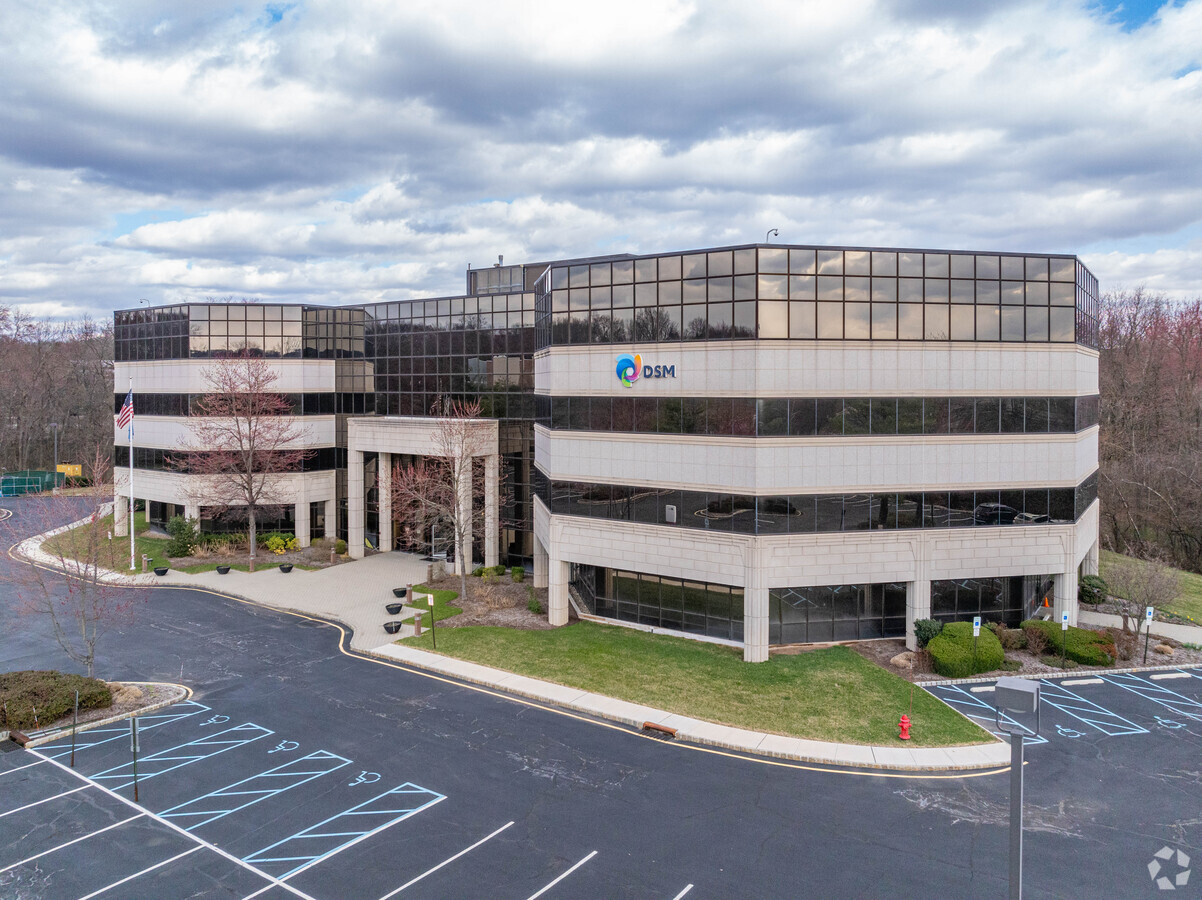
45 Waterview Blvd, Parsippany, NJ 07054


Current Lease Availabilities
NEARBY LISTINGS FOR SALE OR LEASE
Property Detail
45 Waterview Blvd
Newark, NJ-PA
Waterview Corporate Centre
29-00421-4-00001
Morris
Commercialnec
New Jersey
2023
1
2024
10.56 AC
041603
Parsippany
102,995 SF
Northern New Jersey
DEMOGRAPHICS near 45 Waterview Blvd
1 Mile
3 Mile
5 Mile
2024 Total Population
7,489
65,669
139,409
2029 Population
7,522
65,847
139,702
Pop Growth 2024-2029
+ 0.44%
+ 0.27%
+ 0.21%
Average Age
43
42
42
2024 Total Households
2,813
24,724
52,568
HH Growth 2024-2029
+ 0.36%
+ 0.39%
+ 0.25%
Median Household Inc
$95,758
$109,005
$122,266
Avg Household Size
2.60
2.60
2.60
2024 Avg HH Vehicles
2.00
2.00
2.00
Median Home Value
$571,812
$497,292
$551,863
Median Year Built
1964
1966
1968
Nearby Places
- Restaurants
- Banks
- Shops
- Fitness
- Groceries
PUBLIC TRANSPORTATION
COMMUTER RAIL
Mountain Lakes (Montclair-Boonton Line - NJ Transit Commuter Rail (NJ Transit))
DRIVE
WALK
Distance
Mountain Lakes (Montclair-Boonton Line - NJ Transit Commuter Rail (NJ Transit))
4 min
1.4 mi
Boonton (Montclair-Boonton Line - NJ Transit Commuter Rail (NJ Transit))
DRIVE
WALK
Distance
Boonton (Montclair-Boonton Line - NJ Transit Commuter Rail (NJ Transit))
5 min
2.9 mi
AIRPORT
Newark Liberty International
DRIVE
WALK
Distance
Newark Liberty International
34 min
25.8 mi
Laguardia
DRIVE
WALK
Distance
Laguardia
53 min
40.2 mi
Freight Ports
Maher Terminal
DRIVE
WALK
Distance
Maher Terminal
36 min
26.3 mi
Nearby Properties
Address
Land Use
TOTAL SIZE
Lot Size
Zoning
Address
Land Use
TOTAL SIZE
Lot Size
Zoning
2,371 SF
49.38 AC
R-5
Address
Land Use
TOTAL SIZE
Lot Size
Zoning
32.61 AC
R-5
Address
Land Use
TOTAL SIZE
Lot Size
Zoning
377,114 SF
40.64 AC
SD10
Address
Land Use
TOTAL SIZE
Lot Size
Zoning
23.15 AC
SD10
Address
Land Use
TOTAL SIZE
Lot Size
Zoning
13.45 AC
IP
Address
Land Use
TOTAL SIZE
Lot Size
Zoning
23.01 AC
SD10
Address
Land Use
TOTAL SIZE
Lot Size
Zoning
22.85 AC
B-3
Address
Land Use
TOTAL SIZE
Lot Size
Zoning
201,648 SF
19.35 AC
B-1
Address
Land Use
TOTAL SIZE
Lot Size
Zoning
16.01 AC
R-C
Address
Land Use
TOTAL SIZE
Lot Size
Zoning
11.90 AC
OB3
Address
Land Use
TOTAL SIZE
Lot Size
Zoning
91,872 SF
31.16 AC
B-1
Address
Land Use
TOTAL SIZE
Lot Size
Zoning
28.84 AC
OBDS
Address
Land Use
TOTAL SIZE
Lot Size
Zoning
333,991 SF
15.76 AC
SD10
Address
Land Use
TOTAL SIZE
Lot Size
Zoning
428,141 SF
12.30 AC
OB-3
Address
Land Use
TOTAL SIZE
Lot Size
Zoning
197,023 SF
22.08 AC
AHMU
Address
Land Use
TOTAL SIZE
Lot Size
Zoning
374,691 SF
40.71 AC
SD10
Address
Land Use
TOTAL SIZE
Lot Size
Zoning
217,502 SF
25 AC
SED5
Address
Land Use
TOTAL SIZE
Lot Size
Zoning
Address
Land Use
TOTAL SIZE
Lot Size
Zoning
323,904 SF
12 AC
SED5
Address
Land Use
TOTAL SIZE
Lot Size
Zoning
100,392 SF
19.18 AC
B-1
Address
Land Use
TOTAL SIZE
Lot Size
Zoning
4,172 SF
338 AC
R-1
Address
Land Use
TOTAL SIZE
Lot Size
Zoning
132,411 SF
24.87 AC
B-5
Address
Land Use
TOTAL SIZE
Lot Size
Zoning
22.43 AC
IP
Address
Land Use
TOTAL SIZE
Lot Size
Zoning
17.33 AC
R-5
Address
Land Use
TOTAL SIZE
Lot Size
Zoning
10.80 AC
R-5
Address
Land Use
TOTAL SIZE
Lot Size
Zoning
18.39 AC
R-5
Address
Land Use
TOTAL SIZE
Lot Size
Zoning
4.99 AC
OB
Address
Land Use
TOTAL SIZE
Lot Size
Zoning
180,898 SF
21.96 AC
SED5
Address
Land Use
TOTAL SIZE
Lot Size
Zoning
379,285 SF
24.01 AC
SD5A
Address
Land Use
TOTAL SIZE
Lot Size
Zoning
48,455 SF
8.66 AC
POS
The World's #1 Commercial Real Estate Marketplace
Connect with us
© 2025 CoStar Group
The information above has been obtained from sources believed reliable. While we do not doubt its accuracy we have not verified it and make no guarantee, warranty or representation about it. It is your responsibility to independently confirm its accuracy and completeness. Any projections, opinions, assumptions, or estimates used are for example only and do not represent the current or future performance of the property. The value of this transaction to you depends on tax and other factors which should be evaluated by your tax, financial, and legal advisors. You and your advisors should conduct a careful, independent investigation of the property to determine to your satisfaction the suitability of the property for your needs.