Property Record
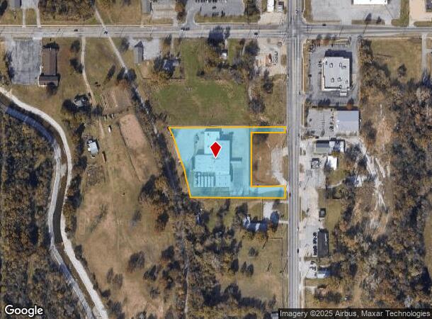
4500 N Peoria Ave, Tulsa, OK 74106
NEARBY LISTINGS FOR SALE OR LEASE
-
-
View all Tulsa listings for lease on LoopNet.com
Property Detail
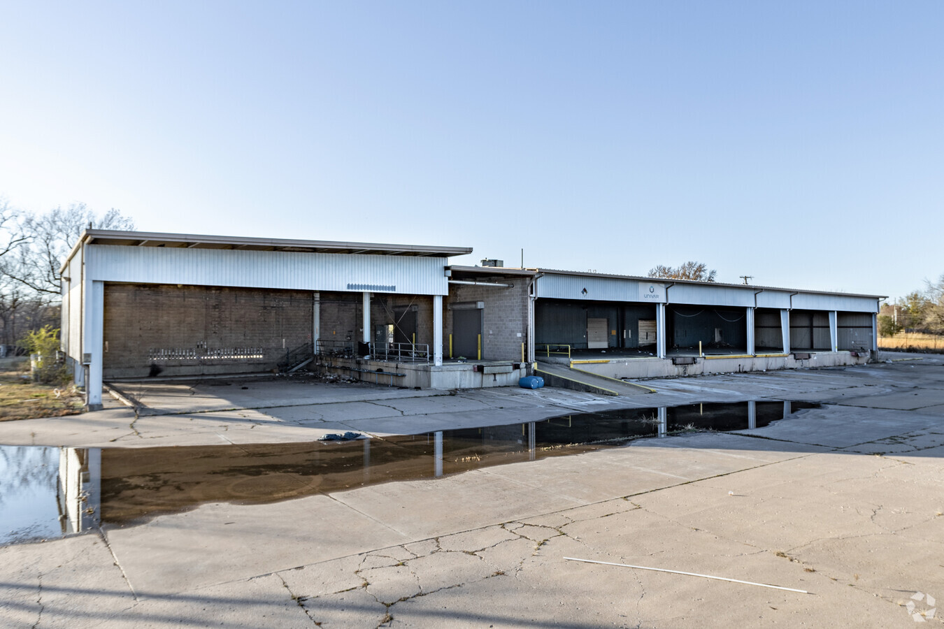
4500 N Peoria Ave
90213-02-13-12420
Unplatted
Warehouse
S313 N733 NE NE LYING E OF ETLY MVRR R/W LESS BEG 25S NEC S313 & N733 NE NE LYING E OF ETLY LN MVRR TH W200 S235 E200 N235 POB & LESS E50 FOR RD SEC 13 20 12 2.69ACS
X
Tulsa
40143C0226L
Oklahoma
2023
2.69 AC
2024
Northwest Tulsa
008002
Tulsa
7,814 SF
Tulsa, OK
DEMOGRAPHICS near 4500 N Peoria Ave
1 Mile
3 Mile
5 Mile
2024 Total Population
7,657
35,062
87,769
2029 Population
8,069
36,972
92,206
Pop Growth 2024-2029
+ 5.38%
+ 5.45%
+ 5.06%
Average Age
37
37
37
2024 Total Households
2,759
13,202
33,122
HH Growth 2024-2029
+ 5.44%
+ 5.50%
+ 5.33%
Median Household Inc
$30,817
$31,219
$36,187
Avg Household Size
2.60
2.50
2.40
2024 Avg HH Vehicles
2.00
2.00
2.00
Median Home Value
$60,177
$73,204
$80,285
Median Year Built
1958
1960
1958
Nearby Places
- Restaurants
- Banks
- Shops
- Fitness
- Groceries
PUBLIC TRANSPORTATION
AIRPORT
Tulsa International
DRIVE
WALK
Distance
Tulsa International
12 min
6.4 mi
Freight Ports
Tulsa Port Of Catoosa
DRIVE
WALK
Distance
Tulsa Port Of Catoosa
22 min
14.6 mi
SALE & LEASE HISTORY
LISTING DATE
SALE/LEASE

Mar 11, 2019
For Lease
Nearby Properties
Address
Land Use
TOTAL SIZE
Lot Size
Zoning
Address
Land Use
TOTAL SIZE
Lot Size
Zoning
10,736 SF
101.62 AC
Address
Land Use
TOTAL SIZE
Lot Size
Zoning
144,570 SF
44.59 AC
RM2
Address
Land Use
TOTAL SIZE
Lot Size
Zoning
94,115 SF
15.18 AC
IM
Address
Land Use
TOTAL SIZE
Lot Size
Zoning
106,579 SF
6.76 AC
RM1
Address
Land Use
TOTAL SIZE
Lot Size
Zoning
40,433 SF
2.92 AC
IL
Address
Land Use
TOTAL SIZE
Lot Size
Zoning
56,476 SF
2.89 AC
RM2
Address
Land Use
TOTAL SIZE
Lot Size
Zoning
29,584 SF
2.99 AC
IM
Address
Land Use
TOTAL SIZE
Lot Size
Zoning
41,874 SF
35.70 AC
RS3
Address
Land Use
TOTAL SIZE
Lot Size
Zoning
29,110 SF
3.96 AC
IL
Address
Land Use
TOTAL SIZE
Lot Size
Zoning
92,364 SF
8.58 AC
RM1
Address
Land Use
TOTAL SIZE
Lot Size
Zoning
29,589 SF
12.36 AC
AG
Address
Land Use
TOTAL SIZE
Lot Size
Zoning
32,700 SF
10.08 AC
AG
Address
Land Use
TOTAL SIZE
Lot Size
Zoning
41,728 SF
10.06 AC
RS3
Address
Land Use
TOTAL SIZE
Lot Size
Zoning
33,750 SF
5.07 AC
RM1
Address
Land Use
TOTAL SIZE
Lot Size
Zoning
36,450 SF
30.52 AC
RS3
Address
Land Use
TOTAL SIZE
Lot Size
Zoning
39,889 SF
3.62 AC
IL
Address
Land Use
TOTAL SIZE
Lot Size
Zoning
43,225 SF
9.30 AC
RS3
Address
Land Use
TOTAL SIZE
Lot Size
Zoning
45,883 SF
10.29 AC
RS3
Address
Land Use
TOTAL SIZE
Lot Size
Zoning
16,164 SF
1.23 AC
CN
Address
Land Use
TOTAL SIZE
Lot Size
Zoning
20,818 SF
2.09 AC
RS4
Address
Land Use
TOTAL SIZE
Lot Size
Zoning
55,867 SF
7.94 AC
RS
Address
Land Use
TOTAL SIZE
Lot Size
Zoning
35,336 SF
1.68 AC
RS3
Address
Land Use
TOTAL SIZE
Lot Size
Zoning
5,670 SF
96.05 AC
AG
Address
Land Use
TOTAL SIZE
Lot Size
Zoning
51,810 SF
7.61 AC
CS
Address
Land Use
TOTAL SIZE
Lot Size
Zoning
27,403 SF
70.91 AC
AG
Address
Land Use
TOTAL SIZE
Lot Size
Zoning
31,154 SF
9.74 AC
RS3
Address
Land Use
TOTAL SIZE
Lot Size
Zoning
14,400 SF
2.32 AC
IL
Address
Land Use
TOTAL SIZE
Lot Size
Zoning
29,065 SF
111.30 AC
RS
Address
Land Use
TOTAL SIZE
Lot Size
Zoning
20,750 SF
1.10 AC
NCU
The World's #1 Commercial Real Estate Marketplace
Connect with us
© 2025 CoStar Group
The information above has been obtained from sources believed reliable. While we do not doubt its accuracy we have not verified it and make no guarantee, warranty or representation about it. It is your responsibility to independently confirm its accuracy and completeness. Any projections, opinions, assumptions, or estimates used are for example only and do not represent the current or future performance of the property. The value of this transaction to you depends on tax and other factors which should be evaluated by your tax, financial, and legal advisors. You and your advisors should conduct a careful, independent investigation of the property to determine to your satisfaction the suitability of the property for your needs.