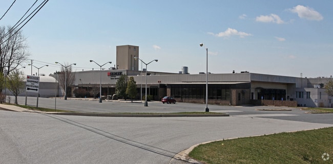
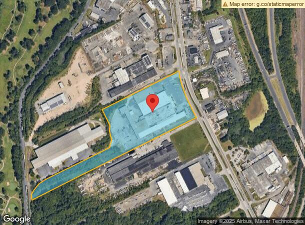
Property Record
4505 N Point Blvd, Sparrows Point, MD 21219

NEARBY LISTINGS FOR SALE OR LEASE
-
-
No Photo
-
-
-
-
-
-
View all Sparrows Point listings for sale on LoopNet.com
Property Detail
4505 N Point Blvd
Baltimore-Columbia-Towson, MD
Hs Processing Company An
15-2200000278
17.981 AC HS PROCESSING COMPANY AN
Lightindustrial
Baltimore
X
Maryland
2400100440H
2
2024
17.98 AC
2025
Baltimore County East
452400
Baltimore
237,059 SF
DEMOGRAPHICS near 4505 N Point Blvd
1 Mile
3 Mile
5 Mile
2024 Total Population
3,446
53,736
125,668
2029 Population
3,405
53,174
123,708
Pop Growth 2024-2029
(1.19%)
(1.05%)
(1.56%)
Average Age
42
40
40
2024 Total Households
1,276
20,379
48,030
HH Growth 2024-2029
(1.33%)
(1.14%)
(1.64%)
Median Household Inc
$68,413
$61,297
$58,954
Avg Household Size
2.60
2.60
2.50
2024 Avg HH Vehicles
2.00
2.00
2.00
Median Home Value
$281,249
$211,818
$198,538
Median Year Built
1957
1955
1956
Nearby Places
Map Layers
Map Styles
 Street
 Aerial
- Restaurants
- Banks
- Shops
- Fitness
- Groceries
PUBLIC TRANSPORTATION
AIRPORT
Baltimore/Washington International Thurgood Marshall
DRIVE
WALK
Distance
Baltimore/Washington International Thurgood Marshall
30 min
18.4 mi
Freight Ports
Port of Baltimore
DRIVE
WALK
Distance
Port of Baltimore
23 min
11.8 mi
Nearby Properties
Address
Land Use
TOTAL SIZE
Lot Size
Zoning
Address
Land Use
TOTAL SIZE
Lot Size
Zoning
1,877,670 SF
90.21 AC
Address
Land Use
TOTAL SIZE
Lot Size
Zoning
Address
Land Use
TOTAL SIZE
Lot Size
Zoning
979,200 SF
49.24 AC
Address
Land Use
TOTAL SIZE
Lot Size
Zoning
859,500 SF
64.32 AC
MH-IM
Address
Land Use
TOTAL SIZE
Lot Size
Zoning
1,500,400 SF
93.63 AC
Address
Land Use
TOTAL SIZE
Lot Size
Zoning
1,282,700 SF
66.23 AC
Address
Land Use
TOTAL SIZE
Lot Size
Zoning
161,190 SF
115.02 AC
Address
Land Use
TOTAL SIZE
Lot Size
Zoning
698,880 SF
60.82 AC
Address
Land Use
TOTAL SIZE
Lot Size
Zoning
519,489 SF
45.05 AC
Address
Land Use
TOTAL SIZE
Lot Size
Zoning
812,250 SF
45.19 AC
Address
Land Use
TOTAL SIZE
Lot Size
Zoning
603,980 SF
30.68 AC
Address
Land Use
TOTAL SIZE
Lot Size
Zoning
291,062 SF
47.39 AC
Address
Land Use
TOTAL SIZE
Lot Size
Zoning
Address
Land Use
TOTAL SIZE
Lot Size
Zoning
735,681 SF
44.98 AC
Address
Land Use
TOTAL SIZE
Lot Size
Zoning
449,920 SF
26.42 AC
Address
Land Use
TOTAL SIZE
Lot Size
Zoning
278,006 SF
49.85 AC
DR
Address
Land Use
TOTAL SIZE
Lot Size
Zoning
401,280 SF
25.38 AC
Address
Land Use
TOTAL SIZE
Lot Size
Zoning
33.65 AC
DR16
Address
Land Use
TOTAL SIZE
Lot Size
Zoning
72,600 SF
35.27 AC
Address
Land Use
TOTAL SIZE
Lot Size
Zoning
399,600 SF
21.59 AC
Address
Land Use
TOTAL SIZE
Lot Size
Zoning
213,997 SF
45.22 AC
DR
Address
Land Use
TOTAL SIZE
Lot Size
Zoning
75.99 AC
Address
Land Use
TOTAL SIZE
Lot Size
Zoning
13.72 AC
DR16
Address
Land Use
TOTAL SIZE
Lot Size
Zoning
12.11 AC
DR16
Address
Land Use
TOTAL SIZE
Lot Size
Zoning
24,300 SF
1.62 AC
MHIM
Address
Land Use
TOTAL SIZE
Lot Size
Zoning
197,823 SF
34.32 AC
DR5.5
Address
Land Use
TOTAL SIZE
Lot Size
Zoning
3,099 SF
16.10 AC
BM
Address
Land Use
TOTAL SIZE
Lot Size
Zoning
189,347 SF
28.24 AC
DR10
Address
Land Use
TOTAL SIZE
Lot Size
Zoning
126,096 SF
14.68 AC
DR105
Address
Land Use
TOTAL SIZE
Lot Size
Zoning
10.27 AC
DR16
The World's #1 Commercial Real Estate Marketplace
Connect with us
© 2026 CoStar Group
The information above has been obtained from sources believed reliable. While we do not doubt its accuracy we have not verified it and make no guarantee, warranty or representation about it. It is your responsibility to independently confirm its accuracy and completeness. Any projections, opinions, assumptions, or estimates used are for example only and do not represent the current or future performance of the property. The value of this transaction to you depends on tax and other factors which should be evaluated by your tax, financial, and legal advisors. You and your advisors should conduct a careful, independent investigation of the property to determine to your satisfaction the suitability of the property for your needs.