Property Record
4510 State Route 52, Jeffersonville, NY 12748
NEARBY LISTINGS FOR SALE OR LEASE
-
-
View all Jeffersonville listings for sale on LoopNet.com
Property Detail
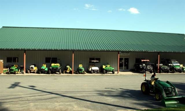
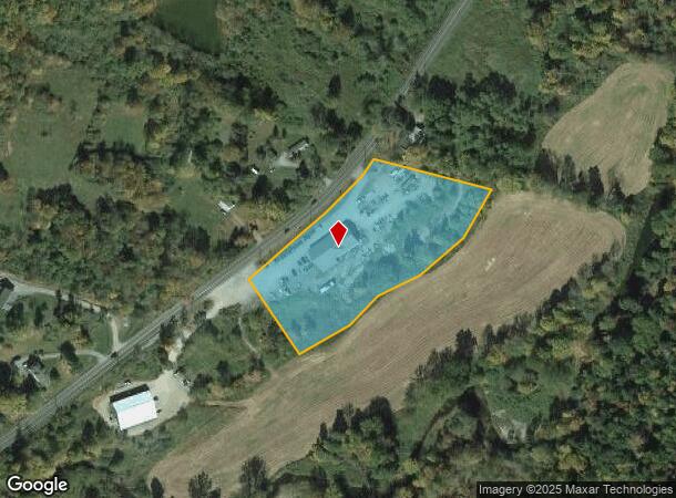
4510 State Route 52
Vehiclerentalsvehiclesales
Sullivan
A
New York
36105C0270F
17.003
2024
3.58 AC
2023
Hudson Valley Area
950400
Other Market Areas
6,000 SF
2289-029-0-0001-017-003
DEMOGRAPHICS near 4510 State Route 52
1 Mile
3 Mile
5 Mile
2024 Total Population
256
1,704
4,042
2029 Population
250
1,688
4,021
Pop Growth 2024-2029
(2.34%)
(0.94%)
(0.52%)
Average Age
48
47
47
2024 Total Households
107
730
1,736
HH Growth 2024-2029
(1.87%)
(0.82%)
(0.29%)
Median Household Inc
$61,250
$62,589
$64,919
Avg Household Size
2.20
2.20
2.20
2024 Avg HH Vehicles
2.00
2.00
2.00
Median Home Value
$278,124
$264,159
$248,615
Median Year Built
1967
1968
1969
Nearby Places
- Restaurants
- Banks
- Shops
- Fitness
- Groceries
Nearby Properties
Address
Land Use
TOTAL SIZE
Lot Size
Zoning
Address
Land Use
TOTAL SIZE
Lot Size
Zoning
61,473 SF
12.30 AC
DD
Address
Land Use
TOTAL SIZE
Lot Size
Zoning
41,500 SF
101.56 AC
04 - FARM
Address
Land Use
TOTAL SIZE
Lot Size
Zoning
1,300 SF
21.16 AC
02 - SINGL
Address
Land Use
TOTAL SIZE
Lot Size
Zoning
Address
Land Use
TOTAL SIZE
Lot Size
Zoning
8,112 SF
1.33 AC
CM
Address
Land Use
TOTAL SIZE
Lot Size
Zoning
Address
Land Use
TOTAL SIZE
Lot Size
Zoning
7,028 SF
0.81 AC
CM
Address
Land Use
TOTAL SIZE
Lot Size
Zoning
13,424 SF
8.37 AC
RU
Address
Land Use
TOTAL SIZE
Lot Size
Zoning
9,100 SF
2.95 AC
04 - FARM
Address
Land Use
TOTAL SIZE
Lot Size
Zoning
840 SF
1 AC
SD
Address
Land Use
TOTAL SIZE
Lot Size
Zoning
816 SF
15.08 AC
04 - FARM
Address
Land Use
TOTAL SIZE
Lot Size
Zoning
2,052 SF
80.70 AC
04 - FARM
Address
Land Use
TOTAL SIZE
Lot Size
Zoning
6,976 SF
0.13 AC
CM
Address
Land Use
TOTAL SIZE
Lot Size
Zoning
8,441 SF
1.94 AC
DD
Address
Land Use
TOTAL SIZE
Lot Size
Zoning
13,750 SF
2.04 AC
CM
Address
Land Use
TOTAL SIZE
Lot Size
Zoning
Address
Land Use
TOTAL SIZE
Lot Size
Zoning
1,568 SF
12.20 AC
04 - FARM
Address
Land Use
TOTAL SIZE
Lot Size
Zoning
11,248 SF
0.50 AC
CM
Address
Land Use
TOTAL SIZE
Lot Size
Zoning
12,352 SF
0.75 AC
BD
Address
Land Use
TOTAL SIZE
Lot Size
Zoning
2,436 SF
46 AC
04 - FARM
Address
Land Use
TOTAL SIZE
Lot Size
Zoning
4,932 SF
0.89 AC
02 - SINGL
Address
Land Use
TOTAL SIZE
Lot Size
Zoning
13,829 SF
7.61 AC
DD
Address
Land Use
TOTAL SIZE
Lot Size
Zoning
3,600 SF
1.40 AC
CM
Address
Land Use
TOTAL SIZE
Lot Size
Zoning
1,892 SF
19.86 AC
04 - FARM
Address
Land Use
TOTAL SIZE
Lot Size
Zoning
3,192 SF
8 AC
04 - FARM
Address
Land Use
TOTAL SIZE
Lot Size
Zoning
451 SF
2.43 AC
02 - SINGL
Address
Land Use
TOTAL SIZE
Lot Size
Zoning
2,040 SF
2.08 AC
RU
Address
Land Use
TOTAL SIZE
Lot Size
Zoning
2,625 SF
0.52 AC
CM
Address
Land Use
TOTAL SIZE
Lot Size
Zoning
4,379 SF
2.95 AC
04 - FARM
Address
Land Use
TOTAL SIZE
Lot Size
Zoning
17,678 SF
4.55 AC
03 - MULTI
The World's #1 Commercial Real Estate Marketplace
Connect with us
© 2025 CoStar Group
The information above has been obtained from sources believed reliable. While we do not doubt its accuracy we have not verified it and make no guarantee, warranty or representation about it. It is your responsibility to independently confirm its accuracy and completeness. Any projections, opinions, assumptions, or estimates used are for example only and do not represent the current or future performance of the property. The value of this transaction to you depends on tax and other factors which should be evaluated by your tax, financial, and legal advisors. You and your advisors should conduct a careful, independent investigation of the property to determine to your satisfaction the suitability of the property for your needs.