Property Record
4607 Division Hwy, East Earl, PA 17519

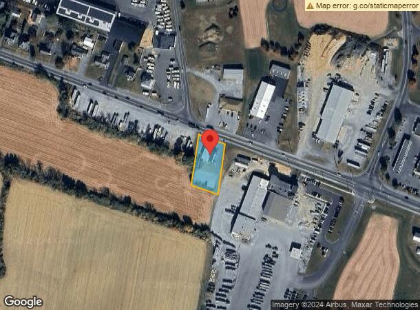
This Property Is For Sale
Current Lease Availabilities
NEARBY LISTINGS FOR SALE OR LEASE
-
-
No Photo
-
-
View all East Earl listings for lease on LoopNet.com
Property Detail
4607 Division Hwy
200-06074-0-0000
4607 DIVISION HWY
Commercialnec
Lancaster
X
Pennsylvania
42071C0406F
17
2024
0.65 AC
2024
Lancaster County
012702
Philadelphia
4,890 SF
Lancaster, PA
DEMOGRAPHICS near 4607 Division Hwy
1 Mile
3 Mile
5 Mile
2024 Total Population
2,073
12,590
28,038
2029 Population
2,042
12,658
28,081
Pop Growth 2024-2029
(1.50%)
+ 0.54%
+ 0.15%
Average Age
39
42
40
2024 Total Households
715
4,536
9,581
HH Growth 2024-2029
(1.68%)
+ 0.73%
+ 0.27%
Median Household Inc
$97,094
$80,330
$76,414
Avg Household Size
2.90
2.70
2.80
2024 Avg HH Vehicles
2.00
2.00
2.00
Median Home Value
$329,720
$290,652
$290,060
Median Year Built
1976
1980
1978
Nearby Places
- Restaurants
- Banks
- Shops
- Fitness
- Groceries
Nearby Properties
Address
Land Use
TOTAL SIZE
Lot Size
Zoning
Address
Land Use
TOTAL SIZE
Lot Size
Zoning
881,497 SF
88.68 AC
R
Address
Land Use
TOTAL SIZE
Lot Size
Zoning
243,536 SF
12 AC
Address
Land Use
TOTAL SIZE
Lot Size
Zoning
273,642 SF
48.10 AC
RA
Address
Land Use
TOTAL SIZE
Lot Size
Zoning
196,406 SF
26.89 AC
R-1
Address
Land Use
TOTAL SIZE
Lot Size
Zoning
115,750 SF
35.58 AC
Address
Land Use
TOTAL SIZE
Lot Size
Zoning
135,220 SF
18.64 AC
CG
Address
Land Use
TOTAL SIZE
Lot Size
Zoning
445,456 SF
29.88 AC
Address
Land Use
TOTAL SIZE
Lot Size
Zoning
335,767 SF
22.20 AC
I
Address
Land Use
TOTAL SIZE
Lot Size
Zoning
117,469 SF
12.63 AC
Address
Land Use
TOTAL SIZE
Lot Size
Zoning
52,884 SF
6.81 AC
R
Address
Land Use
TOTAL SIZE
Lot Size
Zoning
115,934 SF
13.48 AC
Address
Land Use
TOTAL SIZE
Lot Size
Zoning
27,750 SF
23.20 AC
A
Address
Land Use
TOTAL SIZE
Lot Size
Zoning
35,563 SF
87.01 AC
R
Address
Land Use
TOTAL SIZE
Lot Size
Zoning
109,250 SF
8.25 AC
IL
Address
Land Use
TOTAL SIZE
Lot Size
Zoning
50,637 SF
45.99 AC
Address
Land Use
TOTAL SIZE
Lot Size
Zoning
44,663 SF
10.40 AC
AG
Address
Land Use
TOTAL SIZE
Lot Size
Zoning
112,160 SF
8.20 AC
M
Address
Land Use
TOTAL SIZE
Lot Size
Zoning
52,215 SF
8.91 AC
Address
Land Use
TOTAL SIZE
Lot Size
Zoning
45,960 SF
4.28 AC
Address
Land Use
TOTAL SIZE
Lot Size
Zoning
55,188 SF
9.50 AC
C2
Address
Land Use
TOTAL SIZE
Lot Size
Zoning
107,948 SF
12.20 AC
I
Address
Land Use
TOTAL SIZE
Lot Size
Zoning
2,805 SF
13.65 AC
Address
Land Use
TOTAL SIZE
Lot Size
Zoning
106,654 SF
152.20 AC
MR
Address
Land Use
TOTAL SIZE
Lot Size
Zoning
88,548 SF
15.50 AC
Address
Land Use
TOTAL SIZE
Lot Size
Zoning
70,059 SF
5.80 AC
CG
Address
Land Use
TOTAL SIZE
Lot Size
Zoning
31,943 SF
3.10 AC
RL
Address
Land Use
TOTAL SIZE
Lot Size
Zoning
4,284 SF
170 AC
A
Address
Land Use
TOTAL SIZE
Lot Size
Zoning
9,115 SF
96.60 AC
AG
Address
Land Use
TOTAL SIZE
Lot Size
Zoning
53,220 SF
45.60 AC
RL
Address
Land Use
TOTAL SIZE
Lot Size
Zoning
19,628 SF
7.30 AC
R-1
Start a new search to find other properties for sale or lease
Connect with us
© 2024 CoStar Group
The information above has been obtained from sources believed reliable. While we do not doubt its accuracy we have not verified it and make no guarantee, warranty or representation about it. It is your responsibility to independently confirm its accuracy and completeness. Any projections, opinions, assumptions, or estimates used are for example only and do not represent the current or future performance of the property. The value of this transaction to you depends on tax and other factors which should be evaluated by your tax, financial, and legal advisors. You and your advisors should conduct a careful, independent investigation of the property to determine to your satisfaction the suitability of the property for your needs.