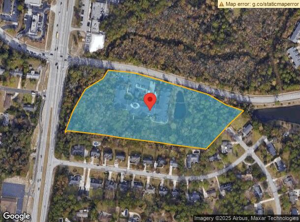
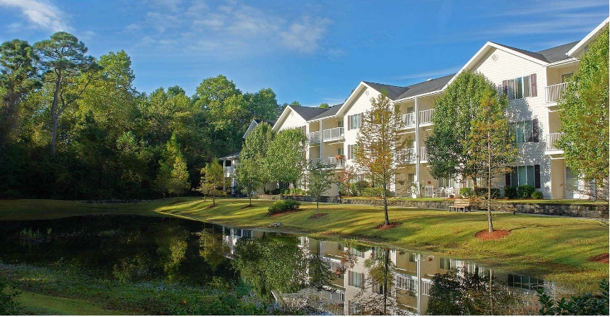
Property Record
4610 Holly Tree Rd, Wilmington, NC 28409

NEARBY LISTINGS FOR SALE OR LEASE
-
-
View all Wilmington listings for sale on LoopNet.com
Property Detail
4610 Holly Tree Rd
Wilmington, NC
5670 Municipal Golf Course
R06100-001-018-000
WATSON BRANCH MASONBORO
Retirementnursinghomecombined
New Hanover
X
North Carolina
3720313600K
18
2023
8.69 AC
2023
Pine Valley East
0120091014
Wilmington
113,447 SF
DEMOGRAPHICS near 4610 Holly Tree Rd
1 Mile
3 Mile
5 Mile
2024 Total Population
6,491
71,709
139,687
2029 Population
6,904
77,583
152,070
Pop Growth 2024-2029
+ 6.36%
+ 8.19%
+ 8.86%
Average Age
43
39
40
2024 Total Households
2,815
31,319
62,172
HH Growth 2024-2029
+ 6.68%
+ 8.87%
+ 9.47%
Median Household Inc
$65,692
$57,616
$59,513
Avg Household Size
2.30
2.10
2.10
2024 Avg HH Vehicles
2.00
2.00
2.00
Median Home Value
$324,798
$295,475
$300,984
Median Year Built
1983
1990
1988
Nearby Places
- Restaurants
- Banks
- Shops
- Fitness
- Groceries
PUBLIC TRANSPORTATION
AIRPORT
Wilmington International
DRIVE
WALK
Distance
Wilmington International
22 min
10.7 mi
Freight Ports
Port of Wilmington
DRIVE
WALK
Distance
Port of Wilmington
10 min
4.6 mi
Nearby Properties
Address
Land Use
TOTAL SIZE
Lot Size
Zoning
Address
Land Use
TOTAL SIZE
Lot Size
Zoning
1,894 SF
649.13 AC
O&I-1
Address
Land Use
TOTAL SIZE
Lot Size
Zoning
11,596 SF
60.45 AC
O&I-1
Address
Land Use
TOTAL SIZE
Lot Size
Zoning
35,334 SF
27.61 AC
O&I
Address
Land Use
TOTAL SIZE
Lot Size
Zoning
29,598 SF
31.57 AC
MF-M,MULTI
Address
Land Use
TOTAL SIZE
Lot Size
Zoning
1,914 SF
15.69 AC
O&I,OFFICE
Address
Land Use
TOTAL SIZE
Lot Size
Zoning
5,563 SF
13.60 AC
MF-M,MULTI
Address
Land Use
TOTAL SIZE
Lot Size
Zoning
111,981 SF
9.34 AC
MX
Address
Land Use
TOTAL SIZE
Lot Size
Zoning
35,124 SF
33.73 AC
MF-M,MULTI
Address
Land Use
TOTAL SIZE
Lot Size
Zoning
606,792 SF
44.13 AC
RB,REGIONA
Address
Land Use
TOTAL SIZE
Lot Size
Zoning
164,021 SF
9.92 AC
MF-M,MULTI
Address
Land Use
TOTAL SIZE
Lot Size
Zoning
224,640 SF
20.30 AC
MF-M,MULTI
Address
Land Use
TOTAL SIZE
Lot Size
Zoning
160,284 SF
59.79 AC
O&I-1
Address
Land Use
TOTAL SIZE
Lot Size
Zoning
298,576 SF
7.79 AC
O&I-1
Address
Land Use
TOTAL SIZE
Lot Size
Zoning
17,517 SF
13.87 AC
MF-M,MULTI
Address
Land Use
TOTAL SIZE
Lot Size
Zoning
192,000 SF
16.78 AC
MF-M,MULTI
Address
Land Use
TOTAL SIZE
Lot Size
Zoning
177,064 SF
8.78 AC
O&I-1
Address
Land Use
TOTAL SIZE
Lot Size
Zoning
4,752 SF
24.34 AC
MF-M,MULTI
Address
Land Use
TOTAL SIZE
Lot Size
Zoning
35,236 SF
30.57 AC
RB,REGIONA
Address
Land Use
TOTAL SIZE
Lot Size
Zoning
26,448 SF
10.80 AC
MF-M,MULTI
Address
Land Use
TOTAL SIZE
Lot Size
Zoning
39,866 SF
15.89 AC
R-15,RESID
Address
Land Use
TOTAL SIZE
Lot Size
Zoning
190,080 SF
22.92 AC
R-15,RESID
Address
Land Use
TOTAL SIZE
Lot Size
Zoning
126,336 SF
14.54 AC
MF-M,MULTI
Address
Land Use
TOTAL SIZE
Lot Size
Zoning
3,384 SF
31.13 AC
MF-M,MULTI
Address
Land Use
TOTAL SIZE
Lot Size
Zoning
6,924 SF
24.11 AC
RB,REGIONA
Address
Land Use
TOTAL SIZE
Lot Size
Zoning
24,966 SF
5.55 AC
O&I-1
Address
Land Use
TOTAL SIZE
Lot Size
Zoning
153,764 SF
22.86 AC
RB,REGIONA
Address
Land Use
TOTAL SIZE
Lot Size
Zoning
72,264 SF
6.42 AC
MF-M,MULTI
Address
Land Use
TOTAL SIZE
Lot Size
Zoning
164,552 SF
25.17 AC
RB,REGIONA
Address
Land Use
TOTAL SIZE
Lot Size
Zoning
40,810 SF
20.75 AC
O&I-1
The World's #1 Commercial Real Estate Marketplace
Connect with us
© 2025 CoStar Group
The information above has been obtained from sources believed reliable. While we do not doubt its accuracy we have not verified it and make no guarantee, warranty or representation about it. It is your responsibility to independently confirm its accuracy and completeness. Any projections, opinions, assumptions, or estimates used are for example only and do not represent the current or future performance of the property. The value of this transaction to you depends on tax and other factors which should be evaluated by your tax, financial, and legal advisors. You and your advisors should conduct a careful, independent investigation of the property to determine to your satisfaction the suitability of the property for your needs.