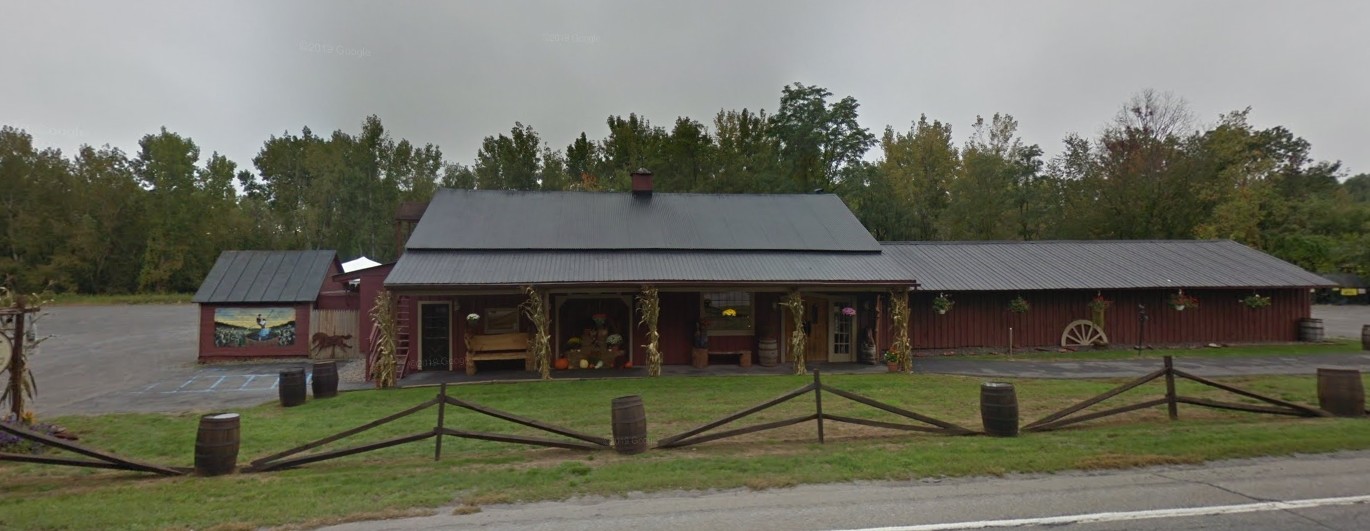
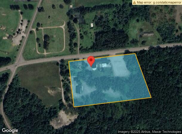
Property Record
462 Route 29, Saratoga Springs, NY 12866
NEARBY LISTINGS FOR SALE OR LEASE
Property Detail
462 Route 29
Albany-Schenectady-Troy, NY
Saratoga
414289 164.-1-43
New York
Storesoffices
43.000
2016
7.04 AC
2023
Saratoga County
061102
Albany/Schenectady/Troy
3,284 SF
DEMOGRAPHICS near 462 Route 29
1 Mile
3 Mile
5 Mile
2024 Total Population
1,079
17,899
48,192
2029 Population
1,126
18,750
50,527
Pop Growth 2024-2029
+ 4.36%
+ 4.75%
+ 4.85%
Average Age
41
43
43
2024 Total Households
406
7,441
21,607
HH Growth 2024-2029
+ 4.43%
+ 4.89%
+ 4.97%
Median Household Inc
$126,786
$92,633
$85,233
Avg Household Size
2.60
2.30
2.20
2024 Avg HH Vehicles
2.00
2.00
2.00
Median Home Value
$305,208
$288,776
$310,760
Median Year Built
1990
1991
1980
Nearby Places
- Restaurants
- Banks
- Shops
- Fitness
- Groceries
PUBLIC TRANSPORTATION
COMMUTER RAIL
Saratoga Springs Amtrak Station (Adirondack - Amtrak, Ethan Allen Express - Amtrak)
DRIVE
WALK
Distance
Saratoga Springs Amtrak Station (Adirondack - Amtrak, Ethan Allen Express - Amtrak)
7 min
3.6 mi
AIRPORT
Albany International
DRIVE
WALK
Distance
Albany International
40 min
29.2 mi
Freight Ports
Albany, NY Port
DRIVE
WALK
Distance
Albany, NY Port
56 min
39.6 mi
Nearby Properties
Address
Land Use
TOTAL SIZE
Lot Size
Zoning
Address
Land Use
TOTAL SIZE
Lot Size
Zoning
12,053 SF
28.28 AC
MU
Address
Land Use
TOTAL SIZE
Lot Size
Zoning
268,548 SF
53 AC
IM
Address
Land Use
TOTAL SIZE
Lot Size
Zoning
905,719 SF
62.10 AC
INDG
Address
Land Use
TOTAL SIZE
Lot Size
Zoning
39,632 SF
19.11 AC
C7
Address
Land Use
TOTAL SIZE
Lot Size
Zoning
4,740 SF
37.10 AC
C7
Address
Land Use
TOTAL SIZE
Lot Size
Zoning
7,300 SF
524.89 AC
A
Address
Land Use
TOTAL SIZE
Lot Size
Zoning
198,381 SF
10.06 AC
PUD
Address
Land Use
TOTAL SIZE
Lot Size
Zoning
12,271 SF
21.12 AC
MU
Address
Land Use
TOTAL SIZE
Lot Size
Zoning
5,152 SF
30.20 AC
UR1
Address
Land Use
TOTAL SIZE
Lot Size
Zoning
9,692 SF
18.13 AC
MU
Address
Land Use
TOTAL SIZE
Lot Size
Zoning
2,160 SF
14.67 AC
R1
Address
Land Use
TOTAL SIZE
Lot Size
Zoning
361,330 SF
25.15 AC
INDG
Address
Land Use
TOTAL SIZE
Lot Size
Zoning
81,122 SF
6.21 AC
Address
Land Use
TOTAL SIZE
Lot Size
Zoning
980 SF
73.69 AC
LDR
Address
Land Use
TOTAL SIZE
Lot Size
Zoning
60,270 SF
20 AC
INSED
Address
Land Use
TOTAL SIZE
Lot Size
Zoning
159,192 SF
25.10 AC
INDG
Address
Land Use
TOTAL SIZE
Lot Size
Zoning
47,860 SF
7.35 AC
C2A
Address
Land Use
TOTAL SIZE
Lot Size
Zoning
768 SF
33.07 AC
R2
Address
Land Use
TOTAL SIZE
Lot Size
Zoning
36,124 SF
6.23 AC
TC
Address
Land Use
TOTAL SIZE
Lot Size
Zoning
118,085 SF
22.26 AC
INDG
Address
Land Use
TOTAL SIZE
Lot Size
Zoning
216,320 SF
29.15 AC
INDG
Address
Land Use
TOTAL SIZE
Lot Size
Zoning
36,192 SF
5.93 AC
CA2
Address
Land Use
TOTAL SIZE
Lot Size
Zoning
832 SF
20 AC
INDG
Address
Land Use
TOTAL SIZE
Lot Size
Zoning
24.73 AC
INDEX
Address
Land Use
TOTAL SIZE
Lot Size
Zoning
34,992 SF
2.75 AC
C2A
Address
Land Use
TOTAL SIZE
Lot Size
Zoning
31,058 SF
3.32 AC
UR1
Address
Land Use
TOTAL SIZE
Lot Size
Zoning
15,549 SF
8.01 AC
UR2
Address
Land Use
TOTAL SIZE
Lot Size
Zoning
90,000 SF
11.27 AC
INDG
Address
Land Use
TOTAL SIZE
Lot Size
Zoning
31,104 SF
3.60 AC
UR1
Address
Land Use
TOTAL SIZE
Lot Size
Zoning
19,023 SF
4.38 AC
C7
The World's #1 Commercial Real Estate Marketplace
Connect with us
© 2025 CoStar Group
The information above has been obtained from sources believed reliable. While we do not doubt its accuracy we have not verified it and make no guarantee, warranty or representation about it. It is your responsibility to independently confirm its accuracy and completeness. Any projections, opinions, assumptions, or estimates used are for example only and do not represent the current or future performance of the property. The value of this transaction to you depends on tax and other factors which should be evaluated by your tax, financial, and legal advisors. You and your advisors should conduct a careful, independent investigation of the property to determine to your satisfaction the suitability of the property for your needs.