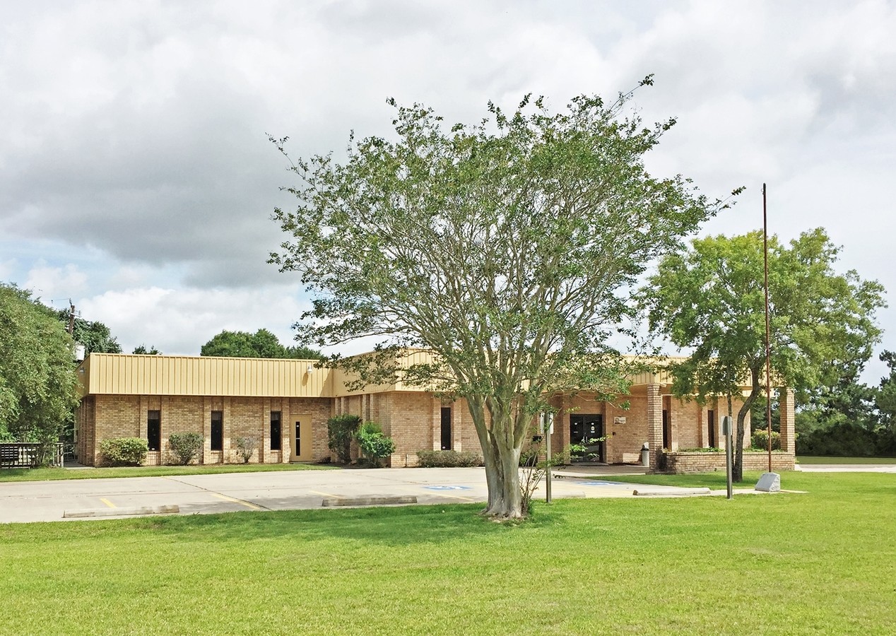
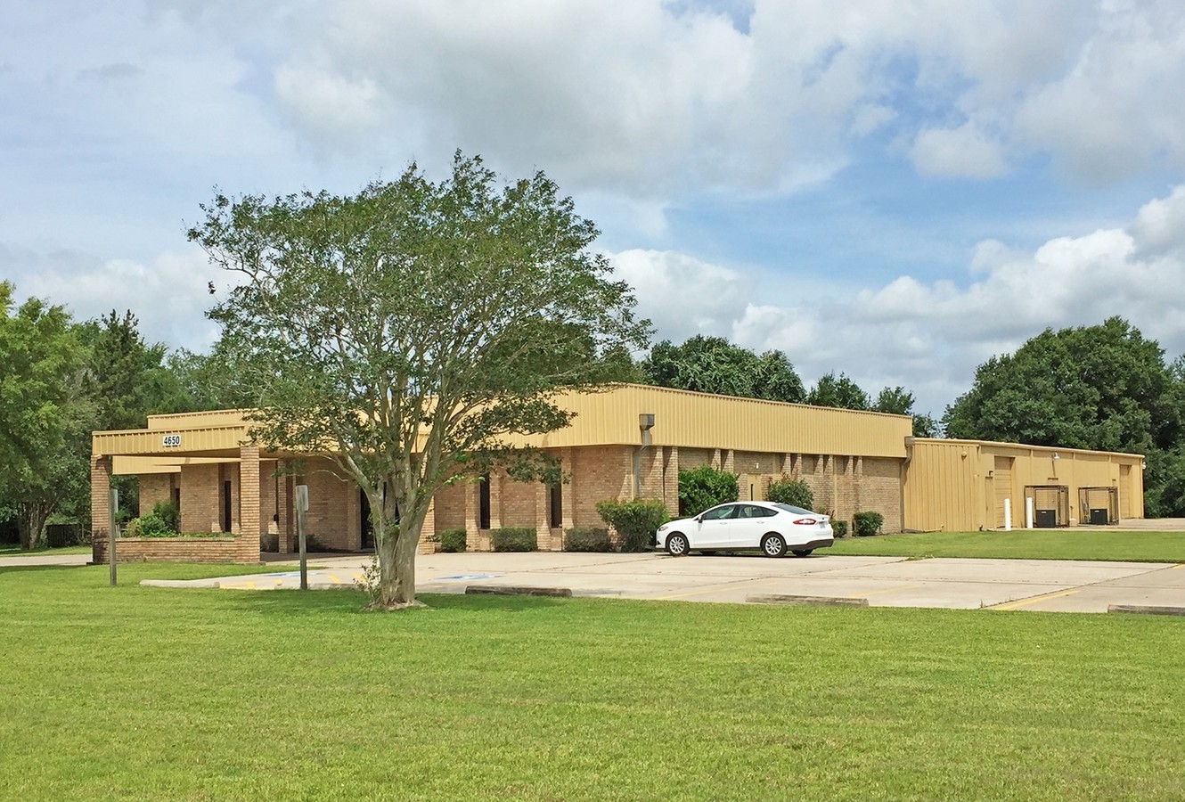
Property Record
4650 Dixie Farm Rd, Pearland, TX 77581
NEARBY LISTINGS FOR SALE OR LEASE
Property Detail
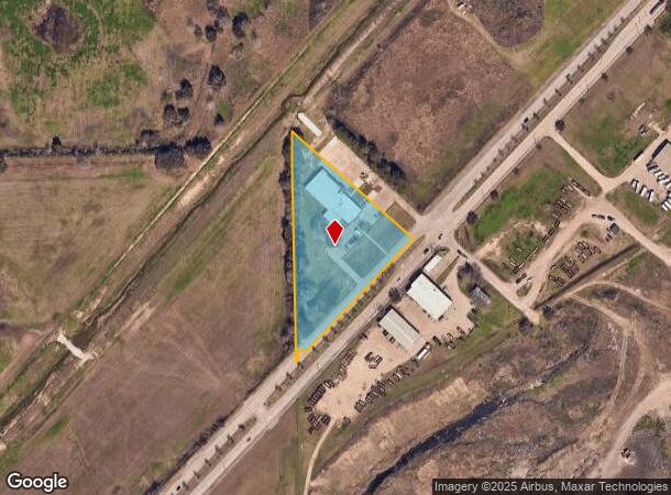
4650 Dixie Farm Rd
0551-0009-100
H T & B R R
Commercialnec
A0551 H T & B R R BLOCK 1 TRACT 1 (COASTAL SPORTS ACADEMY) ACRES 3.7353
X
Brazoria
48039C0044K
Texas
2023
3.74 AC
2023
South Hwy 35
6603003002
Houston
14,452 SF
Houston-The Woodlands-Sugar Land, TX
DEMOGRAPHICS near 4650 Dixie Farm Rd
1 Mile
3 Mile
5 Mile
2024 Total Population
4,090
45,585
141,709
2029 Population
4,486
49,658
150,581
Pop Growth 2024-2029
+ 9.68%
+ 8.93%
+ 6.26%
Average Age
37
38
38
2024 Total Households
1,334
15,706
47,386
HH Growth 2024-2029
+ 9.90%
+ 8.97%
+ 6.38%
Median Household Inc
$139,357
$102,076
$101,443
Avg Household Size
3.00
2.80
2.90
2024 Avg HH Vehicles
2.00
2.00
2.00
Median Home Value
$298,464
$292,181
$274,745
Median Year Built
2002
1994
1994
Nearby Places
- Restaurants
- Banks
- Shops
- Fitness
- Groceries
PUBLIC TRANSPORTATION
AIRPORT
William P Hobby
DRIVE
WALK
Distance
William P Hobby
20 min
9.8 mi
Freight Ports
Port of Houston
DRIVE
WALK
Distance
Port of Houston
31 min
17.9 mi
SALE & LEASE HISTORY
LISTING DATE
SALE/LEASE

Mar 04, 2021
For Lease
Jul 03, 2017
For Sale
Nearby Properties
Address
Land Use
TOTAL SIZE
Lot Size
Zoning
Address
Land Use
TOTAL SIZE
Lot Size
Zoning
40.52 AC
0017
Address
Land Use
TOTAL SIZE
Lot Size
Zoning
83.37 AC
0004
Address
Land Use
TOTAL SIZE
Lot Size
Zoning
64.56 AC
0016
Address
Land Use
TOTAL SIZE
Lot Size
Zoning
236,642 SF
11.48 AC
Address
Land Use
TOTAL SIZE
Lot Size
Zoning
7.42 AC
Address
Land Use
TOTAL SIZE
Lot Size
Zoning
128,754 SF
14.83 AC
Address
Land Use
TOTAL SIZE
Lot Size
Zoning
142,155 SF
19.16 AC
SP
Address
Land Use
TOTAL SIZE
Lot Size
Zoning
144,879 SF
8.91 AC
Address
Land Use
TOTAL SIZE
Lot Size
Zoning
161,803 SF
54.82 AC
Address
Land Use
TOTAL SIZE
Lot Size
Zoning
134,596 SF
7.21 AC
Address
Land Use
TOTAL SIZE
Lot Size
Zoning
89.23 AC
Address
Land Use
TOTAL SIZE
Lot Size
Zoning
100,549 SF
18.25 AC
Address
Land Use
TOTAL SIZE
Lot Size
Zoning
148,902 SF
11.40 AC
Address
Land Use
TOTAL SIZE
Lot Size
Zoning
113,376 SF
9.80 AC
Address
Land Use
TOTAL SIZE
Lot Size
Zoning
129,025 SF
7.02 AC
Address
Land Use
TOTAL SIZE
Lot Size
Zoning
229,097 SF
22.66 AC
Address
Land Use
TOTAL SIZE
Lot Size
Zoning
54,802 SF
12.63 AC
0014
Address
Land Use
TOTAL SIZE
Lot Size
Zoning
81,609 SF
6.56 AC
Address
Land Use
TOTAL SIZE
Lot Size
Zoning
45,108 SF
3.74 AC
Address
Land Use
TOTAL SIZE
Lot Size
Zoning
49.29 AC
0007
Address
Land Use
TOTAL SIZE
Lot Size
Zoning
86,550 SF
8.45 AC
Address
Land Use
TOTAL SIZE
Lot Size
Zoning
63,615 SF
6.42 AC
0010
Address
Land Use
TOTAL SIZE
Lot Size
Zoning
67,595 SF
4.97 AC
Address
Land Use
TOTAL SIZE
Lot Size
Zoning
151,863 SF
15.04 AC
Address
Land Use
TOTAL SIZE
Lot Size
Zoning
83,995 SF
21.74 AC
CSC
Address
Land Use
TOTAL SIZE
Lot Size
Zoning
111,642 SF
9.53 AC
Address
Land Use
TOTAL SIZE
Lot Size
Zoning
95,592 SF
5.93 AC
Address
Land Use
TOTAL SIZE
Lot Size
Zoning
57,558 SF
3.96 AC
0061
Address
Land Use
TOTAL SIZE
Lot Size
Zoning
55,010 SF
5.50 AC
Address
Land Use
TOTAL SIZE
Lot Size
Zoning
60,110 SF
3.88 AC
The World's #1 Commercial Real Estate Marketplace
Connect with us
© 2025 CoStar Group
The information above has been obtained from sources believed reliable. While we do not doubt its accuracy we have not verified it and make no guarantee, warranty or representation about it. It is your responsibility to independently confirm its accuracy and completeness. Any projections, opinions, assumptions, or estimates used are for example only and do not represent the current or future performance of the property. The value of this transaction to you depends on tax and other factors which should be evaluated by your tax, financial, and legal advisors. You and your advisors should conduct a careful, independent investigation of the property to determine to your satisfaction the suitability of the property for your needs.