Property Record
4654 E Markle Rd, Markle, IN 46770
NEARBY LISTINGS FOR SALE OR LEASE
-
-
View all Markle listings for lease on LoopNet.com
Property Detail
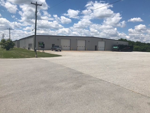
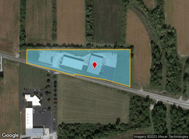
4654 E Markle Rd
35-07-02-100-042.100-014
008-00421-00 PT W NE SEC 2 5.83A
Warehouse
Huntington
X
Indiana
18069C0278D
5.83 AC
2023
Fort Wayne
2023
Other Market Areas
961700
Huntington, IN
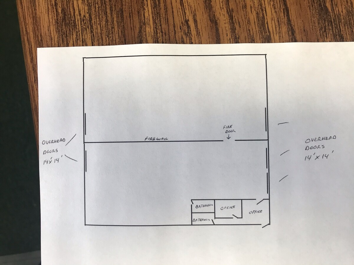
19,200 SF
DEMOGRAPHICS near 4654 E Markle Rd
1 Mile
3 Mile
5 Mile
2024 Total Population
54
1,542
2,778
2029 Population
53
1,525
2,746
Pop Growth 2024-2029
(1.85%)
(1.10%)
(1.15%)
Average Age
42
43
43
2024 Total Households
23
639
1,128
HH Growth 2024-2029
0.00%
(1.10%)
(1.24%)
Median Household Inc
$67,500
$69,673
$73,855
Avg Household Size
2.30
2.40
2.40
2024 Avg HH Vehicles
2.00
2.00
2.00
Median Home Value
$131,250
$160,880
$179,257
Median Year Built
1949
1949
1955
Nearby Places
- Restaurants
- Banks
- Shops
- Fitness
- Groceries
PUBLIC TRANSPORTATION
AIRPORT
Fort Wayne International
DRIVE
WALK
Distance
Fort Wayne International
25 min
17.1 mi
Freight Ports
Port of Toledo
DRIVE
WALK
Distance
Port of Toledo
159 min
128.0 mi
SALE & LEASE HISTORY
LISTING DATE
SALE/LEASE

Jun 21, 2021
For Lease
Nearby Properties
Address
Land Use
TOTAL SIZE
Lot Size
Zoning
Address
Land Use
TOTAL SIZE
Lot Size
Zoning
36.16 AC
Address
Land Use
TOTAL SIZE
Lot Size
Zoning
73,376 SF
20 AC
Address
Land Use
TOTAL SIZE
Lot Size
Zoning
32,481 SF
8.88 AC
Address
Land Use
TOTAL SIZE
Lot Size
Zoning
26,600 SF
38.30 AC
Address
Land Use
TOTAL SIZE
Lot Size
Zoning
38,914 SF
20 AC
Address
Land Use
TOTAL SIZE
Lot Size
Zoning
63,690 SF
20.06 AC
Address
Land Use
TOTAL SIZE
Lot Size
Zoning
36,262 SF
8.03 AC
Address
Land Use
TOTAL SIZE
Lot Size
Zoning
2,420 SF
18.25 AC
Address
Land Use
TOTAL SIZE
Lot Size
Zoning
22,901 SF
4.65 AC
Address
Land Use
TOTAL SIZE
Lot Size
Zoning
39,090 SF
7.98 AC
Address
Land Use
TOTAL SIZE
Lot Size
Zoning
5,940 SF
2.11 AC
Address
Land Use
TOTAL SIZE
Lot Size
Zoning
816 SF
3.55 AC
Address
Land Use
TOTAL SIZE
Lot Size
Zoning
11,587 SF
2.21 AC
Address
Land Use
TOTAL SIZE
Lot Size
Zoning
6,014 SF
1.35 AC
Address
Land Use
TOTAL SIZE
Lot Size
Zoning
234.65 AC
Address
Land Use
TOTAL SIZE
Lot Size
Zoning
13,600 SF
13.99 AC
Address
Land Use
TOTAL SIZE
Lot Size
Zoning
1,296 SF
3.27 AC
Address
Land Use
TOTAL SIZE
Lot Size
Zoning
58,671 SF
1.67 AC
Address
Land Use
TOTAL SIZE
Lot Size
Zoning
14,580 SF
1.29 AC
Address
Land Use
TOTAL SIZE
Lot Size
Zoning
11,570 SF
2 AC
Address
Land Use
TOTAL SIZE
Lot Size
Zoning
27,880 SF
0.71 AC
Address
Land Use
TOTAL SIZE
Lot Size
Zoning
3,627 SF
74.66 AC
Address
Land Use
TOTAL SIZE
Lot Size
Zoning
3,015 SF
0.81 AC
Address
Land Use
TOTAL SIZE
Lot Size
Zoning
5,700 SF
4.11 AC
Address
Land Use
TOTAL SIZE
Lot Size
Zoning
6,280 SF
1.96 AC
Address
Land Use
TOTAL SIZE
Lot Size
Zoning
163.41 AC
Address
Land Use
TOTAL SIZE
Lot Size
Zoning
9,974 SF
0.34 AC
Address
Land Use
TOTAL SIZE
Lot Size
Zoning
4,830 SF
1 AC
Address
Land Use
TOTAL SIZE
Lot Size
Zoning
14,400 SF
1.58 AC
The World's #1 Commercial Real Estate Marketplace
Connect with us
© 2025 CoStar Group
The information above has been obtained from sources believed reliable. While we do not doubt its accuracy we have not verified it and make no guarantee, warranty or representation about it. It is your responsibility to independently confirm its accuracy and completeness. Any projections, opinions, assumptions, or estimates used are for example only and do not represent the current or future performance of the property. The value of this transaction to you depends on tax and other factors which should be evaluated by your tax, financial, and legal advisors. You and your advisors should conduct a careful, independent investigation of the property to determine to your satisfaction the suitability of the property for your needs.