Property Record
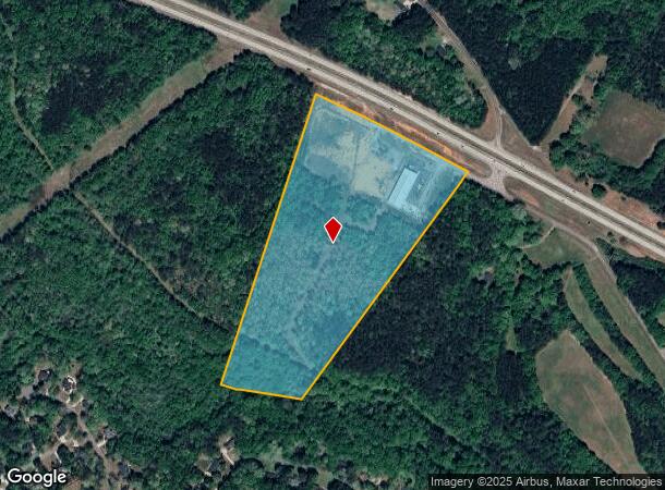
4691 Mars Hill Rd, Bogart, GA 30622
NEARBY LISTINGS FOR SALE OR LEASE
Property Detail
4691 Mars Hill Rd
B01-1-07A
1348/581 1041/546 34/285
Distributionwarehouseregional
Oconee
X
Georgia
13013C0175D
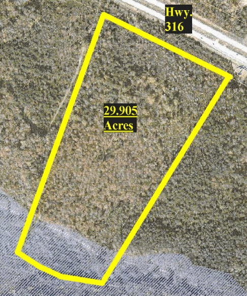
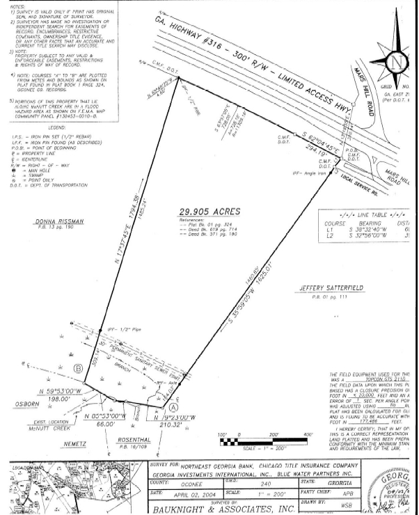
29.91 AC
2024
Athens/Gainesville
2024
Other Market Areas
030103
Athens-Clarke County, GA
6,604 SF
DEMOGRAPHICS near 4691 Mars Hill Rd
1 Mile
3 Mile
5 Mile
2024 Total Population
1,598
12,612
36,197
2029 Population
1,781
13,883
40,015
Pop Growth 2024-2029
+ 11.45%
+ 10.08%
+ 10.55%
Average Age
37
38
39
2024 Total Households
579
4,484
13,578
HH Growth 2024-2029
+ 11.40%
+ 9.88%
+ 9.76%
Median Household Inc
$157,938
$102,234
$82,257
Avg Household Size
2.80
2.80
2.60
2024 Avg HH Vehicles
3.00
2.00
2.00
Median Home Value
$331,120
$309,669
$310,266
Median Year Built
1999
2001
1999
Nearby Places
- Restaurants
- Banks
- Shops
- Fitness
- Groceries
SALE & LEASE HISTORY
LISTING DATE
SALE/LEASE

Sep 24, 2016
For Sale
Nearby Properties
Address
Land Use
TOTAL SIZE
Lot Size
Zoning
Address
Land Use
TOTAL SIZE
Lot Size
Zoning
317,646 SF
55.19 AC
AG
Address
Land Use
TOTAL SIZE
Lot Size
Zoning
93,677 SF
74.41 AC
AG
Address
Land Use
TOTAL SIZE
Lot Size
Zoning
1,020 SF
27.72 AC
RM-1
Address
Land Use
TOTAL SIZE
Lot Size
Zoning
1 SF
126.93 AC
E-I
Address
Land Use
TOTAL SIZE
Lot Size
Zoning
29,874 SF
0.36 AC
O-I-P
Address
Land Use
TOTAL SIZE
Lot Size
Zoning
24.99 AC
G
Address
Land Use
TOTAL SIZE
Lot Size
Zoning
425,000 SF
45.22 AC
I
Address
Land Use
TOTAL SIZE
Lot Size
Zoning
137,764 SF
15.37 AC
C-G
Address
Land Use
TOTAL SIZE
Lot Size
Zoning
10,570 SF
10 AC
C-G
Address
Land Use
TOTAL SIZE
Lot Size
Zoning
28,200 SF
30.09 AC
C-G
Address
Land Use
TOTAL SIZE
Lot Size
Zoning
55,892 SF
4.34 AC
C-G
Address
Land Use
TOTAL SIZE
Lot Size
Zoning
207.90 AC
C-G
Address
Land Use
TOTAL SIZE
Lot Size
Zoning
2,979 SF
203.51 AC
I
Address
Land Use
TOTAL SIZE
Lot Size
Zoning
11,060 SF
5.42 AC
Address
Land Use
TOTAL SIZE
Lot Size
Zoning
99,600 SF
10.12 AC
001
Address
Land Use
TOTAL SIZE
Lot Size
Zoning
4,500 SF
6.06 AC
C-G
Address
Land Use
TOTAL SIZE
Lot Size
Zoning
36,005 SF
4 AC
C-G
Address
Land Use
TOTAL SIZE
Lot Size
Zoning
136.40 AC
R-1
Address
Land Use
TOTAL SIZE
Lot Size
Zoning
65,761 SF
5.05 AC
C-G
Address
Land Use
TOTAL SIZE
Lot Size
Zoning
22,478 SF
5.76 AC
O-I-P
Address
Land Use
TOTAL SIZE
Lot Size
Zoning
11,130 SF
32.08 AC
B-2
Address
Land Use
TOTAL SIZE
Lot Size
Zoning
Address
Land Use
TOTAL SIZE
Lot Size
Zoning
12,284 SF
8.36 AC
O-B-P
Address
Land Use
TOTAL SIZE
Lot Size
Zoning
36,000 SF
0.80 AC
Address
Land Use
TOTAL SIZE
Lot Size
Zoning
36.07 AC
B-2
Address
Land Use
TOTAL SIZE
Lot Size
Zoning
18,145 SF
2.96 AC
C-G
Address
Land Use
TOTAL SIZE
Lot Size
Zoning
29,742 SF
0.76 AC
C-G
Address
Land Use
TOTAL SIZE
Lot Size
Zoning
24,004 SF
16.46 AC
O-I-P
Address
Land Use
TOTAL SIZE
Lot Size
Zoning
6,829 SF
5.93 AC
C-G
Address
Land Use
TOTAL SIZE
Lot Size
Zoning
12,800 SF
7.21 AC
G
The World's #1 Commercial Real Estate Marketplace
Connect with us
© 2025 CoStar Group
The information above has been obtained from sources believed reliable. While we do not doubt its accuracy we have not verified it and make no guarantee, warranty or representation about it. It is your responsibility to independently confirm its accuracy and completeness. Any projections, opinions, assumptions, or estimates used are for example only and do not represent the current or future performance of the property. The value of this transaction to you depends on tax and other factors which should be evaluated by your tax, financial, and legal advisors. You and your advisors should conduct a careful, independent investigation of the property to determine to your satisfaction the suitability of the property for your needs.