Property Record
4700 Kendall Farm Rd, Plano, IL 60545
NEARBY LISTINGS FOR SALE OR LEASE
Property Detail
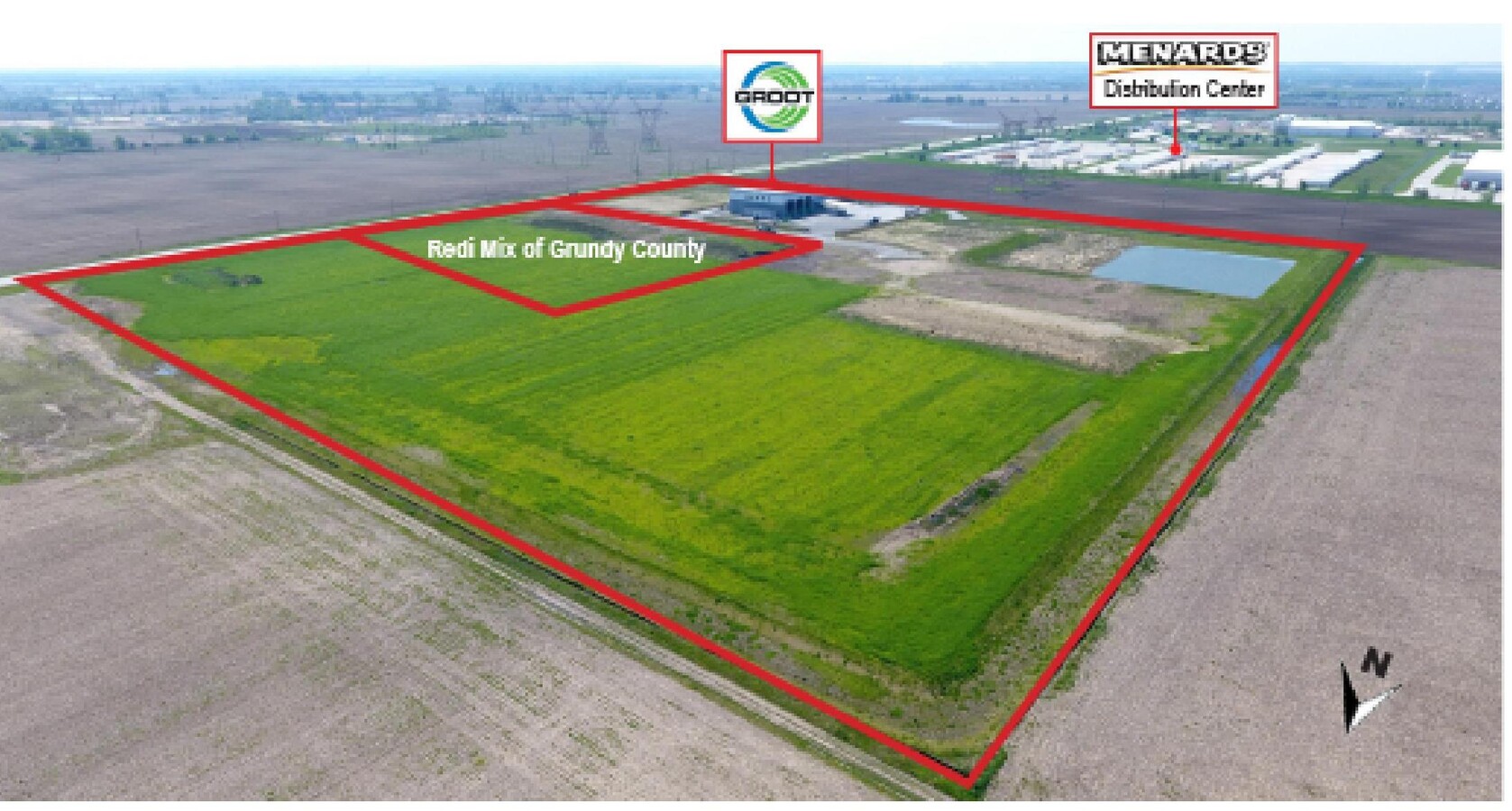
4700 Kendall Farm Rd
Chicago-Naperville-Elgin, IL-IN-WI
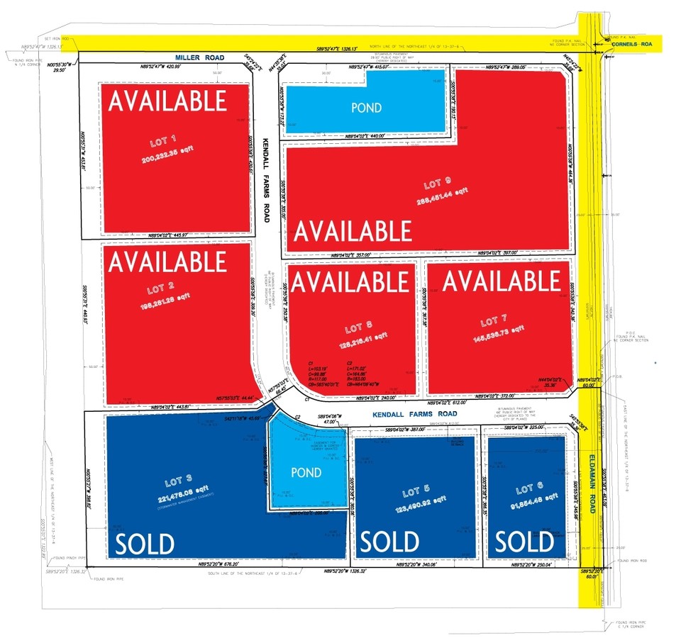
Kendall Farms Industrial Sub Ph 2
01-13-200-010
LT 7 KENDALL FARMS INDUSTRIAL SUB PH 2
Industrialgeneral
Kendall
X
Illinois
17089C0380J
7
2022
3.34 AC
2023
Western East/West Corr
890501
Chicago
DEMOGRAPHICS near 4700 Kendall Farm Rd
1 Mile
3 Mile
5 Mile
2024 Total Population
29
17,045
47,004
2029 Population
32
18,845
51,731
Pop Growth 2024-2029
+ 10.34%
+ 10.56%
+ 10.06%
Average Age
33
36
36
2024 Total Households
9
5,658
15,743
HH Growth 2024-2029
+ 11.11%
+ 10.62%
+ 10.17%
Median Household Inc
$112,500
$90,614
$92,568
Avg Household Size
3.00
2.90
2.90
2024 Avg HH Vehicles
2.00
2.00
2.00
Median Home Value
$262,499
$227,383
$246,691
Median Year Built
2005
2002
2002
Nearby Places
- Restaurants
- Banks
- Shops
- Fitness
- Groceries
PUBLIC TRANSPORTATION
COMMUTER RAIL
Plano Amtrak Station (Carl Sandburg - Amtrak, Illinois Zephyr - Amtrak)
DRIVE
WALK
Distance
Plano Amtrak Station (Carl Sandburg - Amtrak, Illinois Zephyr - Amtrak)
8 min
4.6 mi
Freight Ports
Port Milwaukee
DRIVE
WALK
Distance
Port Milwaukee
151 min
122.4 mi
SALE & LEASE HISTORY
LISTING DATE
SALE/LEASE

Sep 24, 2016
For Sale
May 12, 2017
For Sale
Dec 22, 2016
For Sale
Dec 22, 2016
For Sale
Dec 19, 2019
For Sale
Nearby Properties
Address
Land Use
TOTAL SIZE
Lot Size
Zoning
Address
Land Use
TOTAL SIZE
Lot Size
Zoning
260.24 AC
Address
Land Use
TOTAL SIZE
Lot Size
Zoning
Address
Land Use
TOTAL SIZE
Lot Size
Zoning
0.80 AC
Address
Land Use
TOTAL SIZE
Lot Size
Zoning
7.36 AC
Address
Land Use
TOTAL SIZE
Lot Size
Zoning
13.09 AC
Address
Land Use
TOTAL SIZE
Lot Size
Zoning
177,481 SF
14.11 AC
Address
Land Use
TOTAL SIZE
Lot Size
Zoning
31.25 AC
Address
Land Use
TOTAL SIZE
Lot Size
Zoning
Address
Land Use
TOTAL SIZE
Lot Size
Zoning
107,162 SF
10.49 AC
Address
Land Use
TOTAL SIZE
Lot Size
Zoning
5.63 AC
Address
Land Use
TOTAL SIZE
Lot Size
Zoning
Address
Land Use
TOTAL SIZE
Lot Size
Zoning
90,533 SF
7.18 AC
Address
Land Use
TOTAL SIZE
Lot Size
Zoning
1.07 AC
Address
Land Use
TOTAL SIZE
Lot Size
Zoning
15.67 AC
Address
Land Use
TOTAL SIZE
Lot Size
Zoning
2.83 AC
Address
Land Use
TOTAL SIZE
Lot Size
Zoning
39,784 SF
3 AC
Address
Land Use
TOTAL SIZE
Lot Size
Zoning
3.60 AC
Address
Land Use
TOTAL SIZE
Lot Size
Zoning
2.82 AC
Address
Land Use
TOTAL SIZE
Lot Size
Zoning
9.03 AC
Address
Land Use
TOTAL SIZE
Lot Size
Zoning
2.38 AC
Address
Land Use
TOTAL SIZE
Lot Size
Zoning
6.43 AC
Address
Land Use
TOTAL SIZE
Lot Size
Zoning
Address
Land Use
TOTAL SIZE
Lot Size
Zoning
1,568 SF
8.51 AC
Address
Land Use
TOTAL SIZE
Lot Size
Zoning
12,570 SF
1 AC
Address
Land Use
TOTAL SIZE
Lot Size
Zoning
14,472 SF
15.48 AC
Address
Land Use
TOTAL SIZE
Lot Size
Zoning
Address
Land Use
TOTAL SIZE
Lot Size
Zoning
11,901 SF
0.99 AC
Address
Land Use
TOTAL SIZE
Lot Size
Zoning
7,180 SF
1.30 AC
Address
Land Use
TOTAL SIZE
Lot Size
Zoning
12,550 SF
0.50 AC
Address
Land Use
TOTAL SIZE
Lot Size
Zoning
The World's #1 Commercial Real Estate Marketplace
Connect with us
© 2025 CoStar Group
The information above has been obtained from sources believed reliable. While we do not doubt its accuracy we have not verified it and make no guarantee, warranty or representation about it. It is your responsibility to independently confirm its accuracy and completeness. Any projections, opinions, assumptions, or estimates used are for example only and do not represent the current or future performance of the property. The value of this transaction to you depends on tax and other factors which should be evaluated by your tax, financial, and legal advisors. You and your advisors should conduct a careful, independent investigation of the property to determine to your satisfaction the suitability of the property for your needs.