Property Record
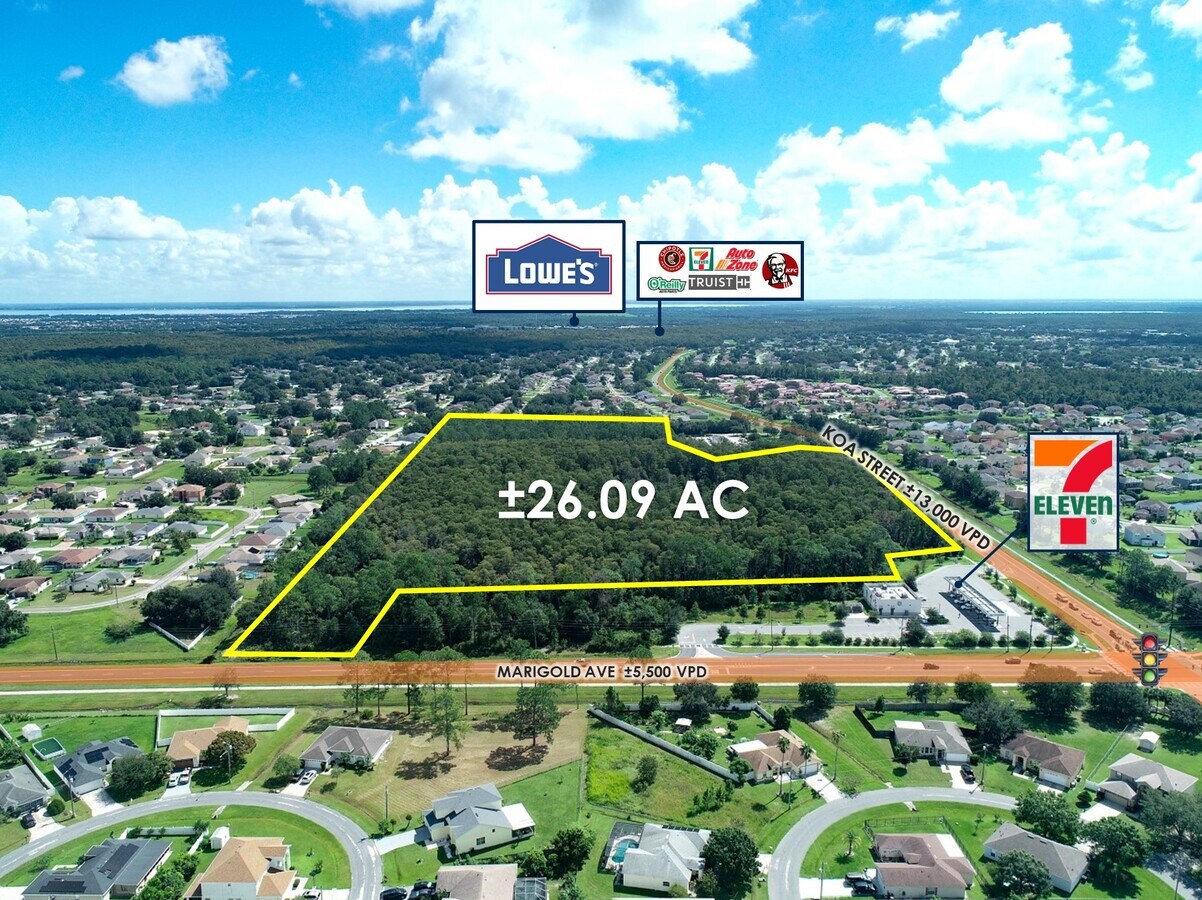
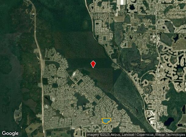
4701 Koa St, Kissimmee, FL 34758

NEARBY LISTINGS FOR SALE OR LEASE
Property Detail
4701 Koa St
Orlando-Kissimmee-Sanford, FL
Poinciana Vlg 1 Nbhd 1 South
25-26-28-6114-000A-0010
POINCIANA NBD 1S V1 PB 3 PG 9 JUNIOR HIGH SCHOOL TRACT A LESS COM AT SW COR OF SEC 1/27/28, E 1248.5 FT TO W R/W OF MARIGOLD AVE, N 218.41 FT TO POC, E 150 FT, NLY 569.98 FT ALONG ARC OF CURVE, CONC WLY, HAVING 11534.16 FT RAD 3 DEG CENT ANG TO POB;
Commercialacreage
Osceola
AE
Florida
12097C0240G
1
2023
26.09 AC
2024
Osceola Outlying
041101
Orlando
DEMOGRAPHICS near 4701 Koa St
1 Mile
3 Mile
5 Mile
2024 Total Population
12,639
52,190
84,156
2029 Population
15,157
62,542
100,952
Pop Growth 2024-2029
+ 19.92%
+ 19.84%
+ 19.96%
Average Age
38
42
41
2024 Total Households
3,803
17,148
27,317
HH Growth 2024-2029
+ 19.77%
+ 19.85%
+ 19.92%
Median Household Inc
$50,156
$56,599
$59,659
Avg Household Size
3.20
2.90
3.00
2024 Avg HH Vehicles
2.00
2.00
2.00
Median Home Value
$192,246
$233,829
$245,817
Median Year Built
2002
2003
2004
Nearby Places
- Restaurants
- Banks
- Shops
- Fitness
- Groceries
PUBLIC TRANSPORTATION
AIRPORT
Orlando International
DRIVE
WALK
Distance
Orlando International
52 min
37.6 mi
Freight Ports
Port Canaveral
DRIVE
WALK
Distance
Port Canaveral
99 min
81.2 mi
SALE & LEASE HISTORY
LISTING DATE
SALE/LEASE

Sep 26, 2022
For Sale
Nearby Properties
Address
Land Use
TOTAL SIZE
Lot Size
Zoning
Address
Land Use
TOTAL SIZE
Lot Size
Zoning
1,348,847 SF
149.36 AC
OPD
Address
Land Use
TOTAL SIZE
Lot Size
Zoning
160,324 SF
35.62 AC
OPD
Address
Land Use
TOTAL SIZE
Lot Size
Zoning
287,237 SF
51.44 AC
OPD
Address
Land Use
TOTAL SIZE
Lot Size
Zoning
241,917 SF
9 AC
Address
Land Use
TOTAL SIZE
Lot Size
Zoning
187,881 SF
87.15 AC
OPUD
Address
Land Use
TOTAL SIZE
Lot Size
Zoning
82,750 SF
11.50 AC
OPUD
Address
Land Use
TOTAL SIZE
Lot Size
Zoning
149,916 SF
29.91 AC
IN
Address
Land Use
TOTAL SIZE
Lot Size
Zoning
341.16 AC
OPUD
Address
Land Use
TOTAL SIZE
Lot Size
Zoning
96,600 SF
2.23 AC
Address
Land Use
TOTAL SIZE
Lot Size
Zoning
115,752 SF
17.53 AC
OPUD
Address
Land Use
TOTAL SIZE
Lot Size
Zoning
39,888 SF
22.22 AC
Address
Land Use
TOTAL SIZE
Lot Size
Zoning
91,329 SF
5.92 AC
OPD
Address
Land Use
TOTAL SIZE
Lot Size
Zoning
61,988 SF
9.39 AC
OPD
Address
Land Use
TOTAL SIZE
Lot Size
Zoning
323,424 SF
4.84 AC
OPD
Address
Land Use
TOTAL SIZE
Lot Size
Zoning
106,475 SF
14.74 AC
OPD
Address
Land Use
TOTAL SIZE
Lot Size
Zoning
75.39 AC
PD
Address
Land Use
TOTAL SIZE
Lot Size
Zoning
261.61 AC
OPUD
Address
Land Use
TOTAL SIZE
Lot Size
Zoning
143,276 SF
8.22 AC
OPD
Address
Land Use
TOTAL SIZE
Lot Size
Zoning
130,387 SF
6.71 AC
OPD
Address
Land Use
TOTAL SIZE
Lot Size
Zoning
20.19 AC
Address
Land Use
TOTAL SIZE
Lot Size
Zoning
139,948 SF
18.52 AC
OPD
Address
Land Use
TOTAL SIZE
Lot Size
Zoning
80,840 SF
19.08 AC
Address
Land Use
TOTAL SIZE
Lot Size
Zoning
4,744 SF
48.23 AC
OPD
Address
Land Use
TOTAL SIZE
Lot Size
Zoning
42,000 SF
0.88 AC
OPD
Address
Land Use
TOTAL SIZE
Lot Size
Zoning
163.90 AC
Address
Land Use
TOTAL SIZE
Lot Size
Zoning
106,398 SF
24.80 AC
OPUD
Address
Land Use
TOTAL SIZE
Lot Size
Zoning
94,529 SF
4.82 AC
OPD
Address
Land Use
TOTAL SIZE
Lot Size
Zoning
112.98 AC
OPUD
Address
Land Use
TOTAL SIZE
Lot Size
Zoning
16,562 SF
2.08 AC
PD
Address
Land Use
TOTAL SIZE
Lot Size
Zoning
The World's #1 Commercial Real Estate Marketplace
Connect with us
© 2025 CoStar Group
The information above has been obtained from sources believed reliable. While we do not doubt its accuracy we have not verified it and make no guarantee, warranty or representation about it. It is your responsibility to independently confirm its accuracy and completeness. Any projections, opinions, assumptions, or estimates used are for example only and do not represent the current or future performance of the property. The value of this transaction to you depends on tax and other factors which should be evaluated by your tax, financial, and legal advisors. You and your advisors should conduct a careful, independent investigation of the property to determine to your satisfaction the suitability of the property for your needs.