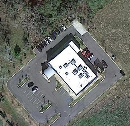
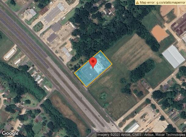
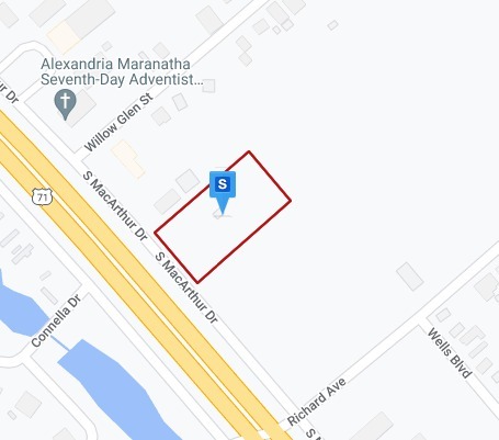
Property Record
4715 S Macarthur Dr, Alexandria, LA 71302
NEARBY LISTINGS FOR SALE OR LEASE
Property Detail
4715 S Macarthur Dr
Other Market Areas
Practice Management Partners
Alexandria, LA
LOT 1A PRACTICE MANAGEMENT PARTNERS SUB: (1.745 ACS): PT LOT 22 SEC 1 WILLOW GLEN PLANTATION FRTG. 202.6' ON MACARTHUR (CB 11
23-044-07740-0001
Rapides
Officebuilding
Louisiana
2023
1a
2023
1.74 AC
012700
Louisiana North Area
9,351 SF
DEMOGRAPHICS near 4715 S Macarthur Dr
1 Mile
3 Mile
5 Mile
2024 Total Population
5,319
26,541
53,367
2029 Population
5,231
26,104
52,394
Pop Growth 2024-2029
(1.65%)
(1.65%)
(1.82%)
Average Age
39
40
39
2024 Total Households
2,148
10,841
21,586
HH Growth 2024-2029
(1.63%)
(1.62%)
(1.83%)
Median Household Inc
$31,695
$37,252
$38,829
Avg Household Size
2.40
2.30
2.30
2024 Avg HH Vehicles
1.00
1.00
1.00
Median Home Value
$130,397
$139,566
$161,078
Median Year Built
1973
1968
1971
Nearby Places
- Restaurants
- Banks
- Shops
- Fitness
- Groceries
PUBLIC TRANSPORTATION
AIRPORT
Alexandria International
DRIVE
WALK
Distance
Alexandria International
24 min
11.1 mi
Freight Ports
Port of Lake Charles
DRIVE
WALK
Distance
Port of Lake Charles
117 min
97.9 mi
Nearby Properties
Address
Land Use
TOTAL SIZE
Lot Size
Zoning
Address
Land Use
TOTAL SIZE
Lot Size
Zoning
Address
Land Use
TOTAL SIZE
Lot Size
Zoning
Address
Land Use
TOTAL SIZE
Lot Size
Zoning
Address
Land Use
TOTAL SIZE
Lot Size
Zoning
54,135 SF
7 AC
Address
Land Use
TOTAL SIZE
Lot Size
Zoning
Address
Land Use
TOTAL SIZE
Lot Size
Zoning
59,500 SF
2.23 AC
Address
Land Use
TOTAL SIZE
Lot Size
Zoning
Address
Land Use
TOTAL SIZE
Lot Size
Zoning
Address
Land Use
TOTAL SIZE
Lot Size
Zoning
57,867 SF
1.80 AC
Address
Land Use
TOTAL SIZE
Lot Size
Zoning
100,959 SF
9 AC
Address
Land Use
TOTAL SIZE
Lot Size
Zoning
4.13 AC
Address
Land Use
TOTAL SIZE
Lot Size
Zoning
Address
Land Use
TOTAL SIZE
Lot Size
Zoning
Address
Land Use
TOTAL SIZE
Lot Size
Zoning
Address
Land Use
TOTAL SIZE
Lot Size
Zoning
Address
Land Use
TOTAL SIZE
Lot Size
Zoning
Address
Land Use
TOTAL SIZE
Lot Size
Zoning
5.77 AC
Address
Land Use
TOTAL SIZE
Lot Size
Zoning
Address
Land Use
TOTAL SIZE
Lot Size
Zoning
Address
Land Use
TOTAL SIZE
Lot Size
Zoning
Address
Land Use
TOTAL SIZE
Lot Size
Zoning
Address
Land Use
TOTAL SIZE
Lot Size
Zoning
Address
Land Use
TOTAL SIZE
Lot Size
Zoning
Address
Land Use
TOTAL SIZE
Lot Size
Zoning
9.68 AC
Address
Land Use
TOTAL SIZE
Lot Size
Zoning
7.25 AC
Address
Land Use
TOTAL SIZE
Lot Size
Zoning
Address
Land Use
TOTAL SIZE
Lot Size
Zoning
12,944 SF
2.70 AC
Address
Land Use
TOTAL SIZE
Lot Size
Zoning
21,000 SF
61 AC
Address
Land Use
TOTAL SIZE
Lot Size
Zoning
The World's #1 Commercial Real Estate Marketplace
Connect with us
© 2025 CoStar Group
The information above has been obtained from sources believed reliable. While we do not doubt its accuracy we have not verified it and make no guarantee, warranty or representation about it. It is your responsibility to independently confirm its accuracy and completeness. Any projections, opinions, assumptions, or estimates used are for example only and do not represent the current or future performance of the property. The value of this transaction to you depends on tax and other factors which should be evaluated by your tax, financial, and legal advisors. You and your advisors should conduct a careful, independent investigation of the property to determine to your satisfaction the suitability of the property for your needs.