Property Record
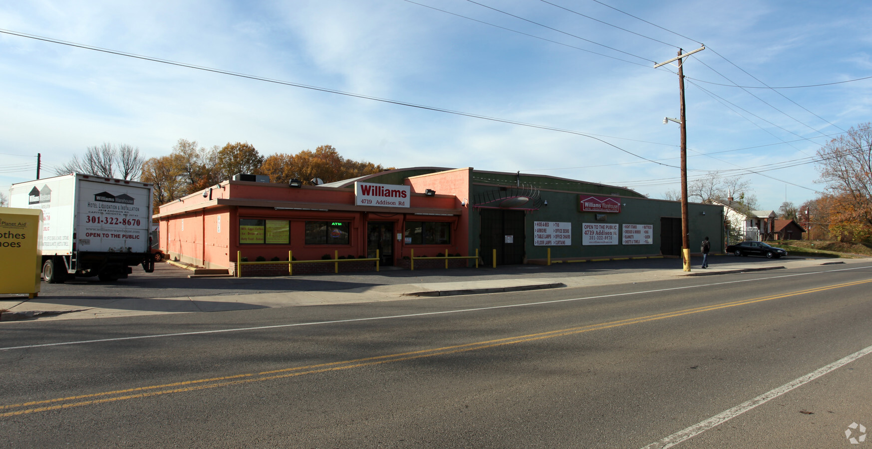
4719 Addison Rd, Capitol Heights, MD 20743


Current Lease Availabilities
NEARBY LISTINGS FOR SALE OR LEASE
Property Detail
4719 Addison Rd
Washington-Arlington-Alexandria, DC-VA-MD-WV
Lowes Addn
18-2024479
LOTS 6.7.8.9 IMPS ON 7 THRU 14
Warehouse
Prince George's
X
Maryland
24033C0141E
6
2024
0.41 AC
2024
Landover/Largo/Captl Hts
803100
Washington, DC
20,780 SF
DEMOGRAPHICS near 4719 Addison Rd
1 Mile
3 Mile
5 Mile
2024 Total Population
17,211
169,514
556,263
2029 Population
16,306
160,967
529,213
Pop Growth 2024-2029
(5.26%)
(5.04%)
(4.86%)
Average Age
39
38
38
2024 Total Households
6,017
62,926
221,129
HH Growth 2024-2029
(5.78%)
(5.72%)
(5.56%)
Median Household Inc
$56,787
$60,532
$76,225
Avg Household Size
2.60
2.60
2.40
2024 Avg HH Vehicles
1.00
1.00
1.00
Median Home Value
$367,953
$350,976
$411,318
Median Year Built
1956
1961
1964
Nearby Places
- Restaurants
- Banks
- Shops
- Fitness
- Groceries
PUBLIC TRANSPORTATION
TRANSIT/SUBWAY
Deanwood (Orange Line - Washington Metropolitan Area Transit Authority Metrorail (Metrorail))
DRIVE
WALK
Distance
Deanwood (Orange Line - Washington Metropolitan Area Transit Authority Metrorail (Metrorail))
2 min
16 min
0.6 mi
COMMUTER RAIL
Riverdale (Camden Line - Maryland Area Regional Commuter Trains (The MARC))
DRIVE
WALK
Distance
Riverdale (Camden Line - Maryland Area Regional Commuter Trains (The MARC))
10 min
4.8 mi
New Carrollton (Penn Line - Maryland Area Regional Commuter Trains (The MARC))
DRIVE
WALK
Distance
New Carrollton (Penn Line - Maryland Area Regional Commuter Trains (The MARC))
10 min
6.1 mi
AIRPORT
Ronald Reagan Washington Ntl
DRIVE
WALK
Distance
Ronald Reagan Washington Ntl
20 min
11.9 mi
Baltimore/Washington International Thurgood Marshall
DRIVE
WALK
Distance
Baltimore/Washington International Thurgood Marshall
40 min
27.0 mi
Washington Dulles International
DRIVE
WALK
Distance
Washington Dulles International
55 min
34.7 mi
Freight Ports
Port of Baltimore
DRIVE
WALK
Distance
Port of Baltimore
50 min
33.6 mi
Nearby Properties
Address
Land Use
TOTAL SIZE
Lot Size
Zoning
Address
Land Use
TOTAL SIZE
Lot Size
Zoning
418.97 AC
MU-4,UNZON
Address
Land Use
TOTAL SIZE
Lot Size
Zoning
169.85 AC
R-2,UNZONE
Address
Land Use
TOTAL SIZE
Lot Size
Zoning
2,149,330 SF
11.60 AC
UNZONED
Address
Land Use
TOTAL SIZE
Lot Size
Zoning
535,277 SF
0.40 AC
D-6
Address
Land Use
TOTAL SIZE
Lot Size
Zoning
944,105 SF
23.09 AC
CGO
Address
Land Use
TOTAL SIZE
Lot Size
Zoning
236,535 SF
12.54 AC
R-2
Address
Land Use
TOTAL SIZE
Lot Size
Zoning
62.03 AC
UNZONED
Address
Land Use
TOTAL SIZE
Lot Size
Zoning
241,725 SF
4.71 AC
MU-7B,PDR-
Address
Land Use
TOTAL SIZE
Lot Size
Zoning
821,240 SF
48.32 AC
IH
Address
Land Use
TOTAL SIZE
Lot Size
Zoning
1.51 AC
MU-7B
Address
Land Use
TOTAL SIZE
Lot Size
Zoning
56,064 SF
7.67 AC
R-2,RA-1
Address
Land Use
TOTAL SIZE
Lot Size
Zoning
230,000 SF
4.25 AC
MU-5A,RA-4
Address
Land Use
TOTAL SIZE
Lot Size
Zoning
419,689 SF
66.84 AC
PDR-1,PDR-
Address
Land Use
TOTAL SIZE
Lot Size
Zoning
270,109 SF
17.63 AC
PDR-1,PDR-
Address
Land Use
TOTAL SIZE
Lot Size
Zoning
272 SF
0.55 AC
R2
Address
Land Use
TOTAL SIZE
Lot Size
Zoning
25.33 AC
UNZONED
Address
Land Use
TOTAL SIZE
Lot Size
Zoning
262,236 SF
15.26 AC
RA-1
Address
Land Use
TOTAL SIZE
Lot Size
Zoning
107,130 SF
2.98 AC
R-2,RA-1
Address
Land Use
TOTAL SIZE
Lot Size
Zoning
72.47 AC
HE-3,UNZON
Address
Land Use
TOTAL SIZE
Lot Size
Zoning
92,511 SF
1.48 AC
RA-1
Address
Land Use
TOTAL SIZE
Lot Size
Zoning
181,530 SF
4.72 AC
R-2
Address
Land Use
TOTAL SIZE
Lot Size
Zoning
22.19 AC
UNZONED
Address
Land Use
TOTAL SIZE
Lot Size
Zoning
21.38 AC
RA-2
Address
Land Use
TOTAL SIZE
Lot Size
Zoning
446,789 SF
17.52 AC
RA-2
Address
Land Use
TOTAL SIZE
Lot Size
Zoning
3,312 SF
74.47 AC
PDR-1,RF-1
Address
Land Use
TOTAL SIZE
Lot Size
Zoning
10.63 AC
RMF20
Address
Land Use
TOTAL SIZE
Lot Size
Zoning
194,850 SF
8.90 AC
LTOE
Address
Land Use
TOTAL SIZE
Lot Size
Zoning
57.68 AC
UNZONED
Address
Land Use
TOTAL SIZE
Lot Size
Zoning
18.35 AC
UNZONED
Address
Land Use
TOTAL SIZE
Lot Size
Zoning
142,636 SF
3.69 AC
RA-1
The World's #1 Commercial Real Estate Marketplace
Connect with us
© 2025 CoStar Group
The information above has been obtained from sources believed reliable. While we do not doubt its accuracy we have not verified it and make no guarantee, warranty or representation about it. It is your responsibility to independently confirm its accuracy and completeness. Any projections, opinions, assumptions, or estimates used are for example only and do not represent the current or future performance of the property. The value of this transaction to you depends on tax and other factors which should be evaluated by your tax, financial, and legal advisors. You and your advisors should conduct a careful, independent investigation of the property to determine to your satisfaction the suitability of the property for your needs.