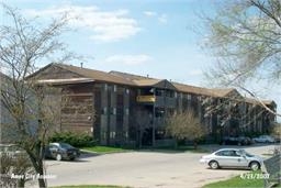
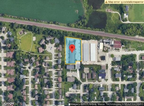
Property Record
4733 Toronto St, Ames, IA 50014
NEARBY LISTINGS FOR SALE OR LEASE
Property Detail
4733 Toronto St
Ames, IA
Hellman Add
05-31-475-125
HELLMAN ADD LOT 4 BEG NW COR SE202.58' S269.10' W70' S33.37' W130' N TO BEG
Apartment
Story
X
Iowa
19015C0250D
4
2024
1.36 AC
2024
West Ames
000600
Other Market Areas
38,235 SF
DEMOGRAPHICS near 4733 Toronto St
1 Mile
3 Mile
5 Mile
2024 Total Population
4,944
45,869
67,320
2029 Population
5,162
47,207
69,347
Pop Growth 2024-2029
+ 4.41%
+ 2.92%
+ 3.01%
Average Age
35
31
33
2024 Total Households
2,072
16,769
27,053
HH Growth 2024-2029
+ 4.44%
+ 3.42%
+ 3.41%
Median Household Inc
$77,602
$56,813
$57,798
Avg Household Size
2.30
2.20
2.10
2024 Avg HH Vehicles
2.00
2.00
2.00
Median Home Value
$261,417
$273,379
$252,260
Median Year Built
1984
1994
1990
Nearby Places
- Restaurants
- Banks
- Shops
- Fitness
- Groceries
Nearby Properties
Address
Land Use
TOTAL SIZE
Lot Size
Zoning
Address
Land Use
TOTAL SIZE
Lot Size
Zoning
289,606 SF
1.77 AC
CSC
Address
Land Use
TOTAL SIZE
Lot Size
Zoning
82,734 SF
1.42 AC
CSC
Address
Land Use
TOTAL SIZE
Lot Size
Zoning
16,222 SF
10.44 AC
Address
Land Use
TOTAL SIZE
Lot Size
Zoning
117,797 SF
7.88 AC
Address
Land Use
TOTAL SIZE
Lot Size
Zoning
7,314 SF
8.91 AC
RH
Address
Land Use
TOTAL SIZE
Lot Size
Zoning
133,668 SF
3.71 AC
RH
Address
Land Use
TOTAL SIZE
Lot Size
Zoning
20,619 SF
2.44 AC
RH
Address
Land Use
TOTAL SIZE
Lot Size
Zoning
920 SF
20.72 AC
F-PRD
Address
Land Use
TOTAL SIZE
Lot Size
Zoning
97,767 SF
0.05 AC
CSC
Address
Land Use
TOTAL SIZE
Lot Size
Zoning
100,588 SF
7.65 AC
HOC
Address
Land Use
TOTAL SIZE
Lot Size
Zoning
63,021 SF
3.43 AC
Address
Land Use
TOTAL SIZE
Lot Size
Zoning
52,904 SF
2.13 AC
RH
Address
Land Use
TOTAL SIZE
Lot Size
Zoning
26.37 AC
SGA
Address
Land Use
TOTAL SIZE
Lot Size
Zoning
72,459 SF
3.06 AC
CCR
Address
Land Use
TOTAL SIZE
Lot Size
Zoning
105,550 SF
0.62 AC
CSC
Address
Land Use
TOTAL SIZE
Lot Size
Zoning
30,207 SF
4.81 AC
Address
Land Use
TOTAL SIZE
Lot Size
Zoning
19,656 SF
4.86 AC
RH
Address
Land Use
TOTAL SIZE
Lot Size
Zoning
41,000 SF
1.73 AC
Address
Land Use
TOTAL SIZE
Lot Size
Zoning
990 SF
5.66 AC
RH
Address
Land Use
TOTAL SIZE
Lot Size
Zoning
43,805 SF
4.65 AC
HOC
Address
Land Use
TOTAL SIZE
Lot Size
Zoning
12,960 SF
15.64 AC
C-1
Address
Land Use
TOTAL SIZE
Lot Size
Zoning
31,254 SF
3.51 AC
F-PRD
Address
Land Use
TOTAL SIZE
Lot Size
Zoning
35,356 SF
3.16 AC
CCN
Address
Land Use
TOTAL SIZE
Lot Size
Zoning
25,503 SF
21.34 AC
FSRL
Address
Land Use
TOTAL SIZE
Lot Size
Zoning
19,259 SF
12.38 AC
C
Address
Land Use
TOTAL SIZE
Lot Size
Zoning
7,938 SF
3.86 AC
CCN
Address
Land Use
TOTAL SIZE
Lot Size
Zoning
72,810 SF
3.80 AC
C-1
Address
Land Use
TOTAL SIZE
Lot Size
Zoning
588 SF
3.04 AC
HOC
Address
Land Use
TOTAL SIZE
Lot Size
Zoning
63,714 SF
9.08 AC
RL
Address
Land Use
TOTAL SIZE
Lot Size
Zoning
31,430 SF
4.77 AC
CCN
The World's #1 Commercial Real Estate Marketplace
Connect with us
© 2025 CoStar Group
The information above has been obtained from sources believed reliable. While we do not doubt its accuracy we have not verified it and make no guarantee, warranty or representation about it. It is your responsibility to independently confirm its accuracy and completeness. Any projections, opinions, assumptions, or estimates used are for example only and do not represent the current or future performance of the property. The value of this transaction to you depends on tax and other factors which should be evaluated by your tax, financial, and legal advisors. You and your advisors should conduct a careful, independent investigation of the property to determine to your satisfaction the suitability of the property for your needs.