Property Record
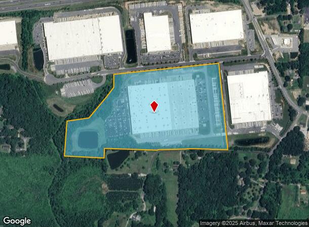
4750 Mcconnell Center Dr, Greensboro, NC 27405
NEARBY LISTINGS FOR SALE OR LEASE
Property Detail
4750 Mcconnell Center Dr
Greensboro-High Point, NC
Mcconnell
0084371
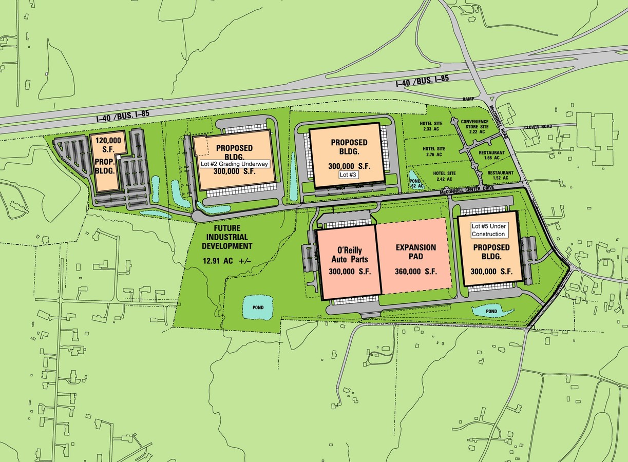
OREILLY DISTRIBUTION CNT/MCCONNELL CNTR
Industrialgeneral
Guilford
X
North Carolina
3710789300J
6
2023
39.50 AC
2023
SE Guilford County
017200
Greensboro/Winston-Salem
160 SF
DEMOGRAPHICS near 4750 Mcconnell Center Dr
1 Mile
3 Mile
5 Mile
2024 Total Population
2,187
15,288
60,894
2029 Population
2,162
15,161
60,944
Pop Growth 2024-2029
(1.14%)
(0.83%)
+ 0.08%
Average Age
37
38
38
2024 Total Households
840
5,659
22,706
HH Growth 2024-2029
(1.07%)
(0.83%)
+ 0.15%
Median Household Inc
$55,499
$60,434
$46,221
Avg Household Size
2.60
2.60
2.50
2024 Avg HH Vehicles
2.00
2.00
2.00
Median Home Value
$182,829
$183,263
$161,592
Median Year Built
2000
1996
1979
Nearby Places
- Restaurants
- Banks
- Shops
- Fitness
- Groceries
PUBLIC TRANSPORTATION
COMMUTER RAIL
Greensboro Station (Piedmont - North Carolina by Train (NC Train))
DRIVE
WALK
Distance
Greensboro Station (Piedmont - North Carolina by Train (NC Train))
14 min
7.5 mi
AIRPORT
Piedmont Triad International
DRIVE
WALK
Distance
Piedmont Triad International
31 min
17.8 mi
Freight Ports
Virginia Port Authority - Richmond
DRIVE
WALK
Distance
Virginia Port Authority - Richmond
221 min
191.8 mi
Nearby Properties
Address
Land Use
TOTAL SIZE
Lot Size
Zoning
Address
Land Use
TOTAL SIZE
Lot Size
Zoning
2,340,205 SF
338.69 AC
LI
Address
Land Use
TOTAL SIZE
Lot Size
Zoning
402,136 SF
33.79 AC
CD-C-H
Address
Land Use
TOTAL SIZE
Lot Size
Zoning
418,596 SF
23.53 AC
CD-LI
Address
Land Use
TOTAL SIZE
Lot Size
Zoning
224,444 SF
79.85 AC
PI
Address
Land Use
TOTAL SIZE
Lot Size
Zoning
275,282 SF
43.43 AC
PI
Address
Land Use
TOTAL SIZE
Lot Size
Zoning
173,361 SF
20.81 AC
BP
Address
Land Use
TOTAL SIZE
Lot Size
Zoning
344,972 SF
65.45 AC
CU-LI
Address
Land Use
TOTAL SIZE
Lot Size
Zoning
281,330 SF
21.18 AC
AG
Address
Land Use
TOTAL SIZE
Lot Size
Zoning
419,126 SF
33.68 AC
CU-LI
Address
Land Use
TOTAL SIZE
Lot Size
Zoning
240,170 SF
14.01 AC
AG
Address
Land Use
TOTAL SIZE
Lot Size
Zoning
301,592 SF
19.38 AC
CD-LI
Address
Land Use
TOTAL SIZE
Lot Size
Zoning
238,315 SF
19.63 AC
RM-12
Address
Land Use
TOTAL SIZE
Lot Size
Zoning
652,985 SF
104.62 AC
BP
Address
Land Use
TOTAL SIZE
Lot Size
Zoning
128,500 SF
14.15 AC
AG
Address
Land Use
TOTAL SIZE
Lot Size
Zoning
85,715 SF
15.34 AC
CU-PDM
Address
Land Use
TOTAL SIZE
Lot Size
Zoning
146,028 SF
11.36 AC
BP
Address
Land Use
TOTAL SIZE
Lot Size
Zoning
2,768 SF
133.07 AC
CD-HI
Address
Land Use
TOTAL SIZE
Lot Size
Zoning
67,872 SF
9.94 AC
GO-M
Address
Land Use
TOTAL SIZE
Lot Size
Zoning
86,400 SF
7.11 AC
BP
Address
Land Use
TOTAL SIZE
Lot Size
Zoning
65,756 SF
121.44 AC
AG
Address
Land Use
TOTAL SIZE
Lot Size
Zoning
46,528 SF
38.51 AC
LI
Address
Land Use
TOTAL SIZE
Lot Size
Zoning
48,552 SF
13.68 AC
CU-RM-18
Address
Land Use
TOTAL SIZE
Lot Size
Zoning
39,775 SF
2.28 AC
CU-HB
Address
Land Use
TOTAL SIZE
Lot Size
Zoning
21.52 AC
AG
Address
Land Use
TOTAL SIZE
Lot Size
Zoning
74,926 SF
8.57 AC
LI
Address
Land Use
TOTAL SIZE
Lot Size
Zoning
66,372 SF
17.77 AC
LI
Address
Land Use
TOTAL SIZE
Lot Size
Zoning
110,332 SF
20.17 AC
AG
Address
Land Use
TOTAL SIZE
Lot Size
Zoning
43,428 SF
4.58 AC
AG
Address
Land Use
TOTAL SIZE
Lot Size
Zoning
128,840 SF
13.29 AC
CU-HI
The World's #1 Commercial Real Estate Marketplace
Connect with us
© 2025 CoStar Group
The information above has been obtained from sources believed reliable. While we do not doubt its accuracy we have not verified it and make no guarantee, warranty or representation about it. It is your responsibility to independently confirm its accuracy and completeness. Any projections, opinions, assumptions, or estimates used are for example only and do not represent the current or future performance of the property. The value of this transaction to you depends on tax and other factors which should be evaluated by your tax, financial, and legal advisors. You and your advisors should conduct a careful, independent investigation of the property to determine to your satisfaction the suitability of the property for your needs.