Property Record
47W722 Terwilliger Ave, Hampshire, IL 60140
NEARBY LISTINGS FOR SALE OR LEASE
-
-
View all Hampshire listings for sale on LoopNet.com
Property Detail
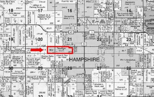
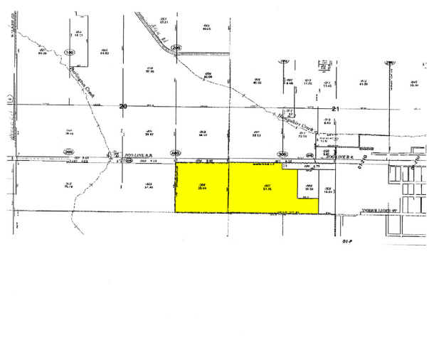
47W722 Terwilliger Ave
01-20-400-004
Village Hampshire
Farms
Kane
X
Illinois
17089C0106J
38.44 AC
2023
Far Northwest
2023
Chicago
850705
Chicago-Naperville-Elgin, IL-IN-WI
DEMOGRAPHICS near 47W722 Terwilliger Ave
1 Mile
3 Mile
5 Mile
2024 Total Population
3,257
7,322
13,078
2029 Population
3,231
7,274
12,926
Pop Growth 2024-2029
(0.80%)
(0.66%)
(1.16%)
Average Age
40
39
41
2024 Total Households
1,178
2,649
4,841
HH Growth 2024-2029
(1.02%)
(0.83%)
(1.32%)
Median Household Inc
$95,160
$99,824
$103,414
Avg Household Size
2.70
2.70
2.70
2024 Avg HH Vehicles
3.00
2.00
2.00
Median Home Value
$306,098
$321,159
$328,353
Median Year Built
1992
1992
1999
Nearby Places
- Restaurants
- Banks
- Shops
- Fitness
- Groceries
PUBLIC TRANSPORTATION
AIRPORT
Chicago/Rockford International
DRIVE
WALK
Distance
Chicago/Rockford International
59 min
36.7 mi
Freight Ports
Port Milwaukee
DRIVE
WALK
Distance
Port Milwaukee
126 min
89.5 mi
Nearby Properties
Address
Land Use
TOTAL SIZE
Lot Size
Zoning
Address
Land Use
TOTAL SIZE
Lot Size
Zoning
152,275 SF
12.22 AC
I DISTRICT
Address
Land Use
TOTAL SIZE
Lot Size
Zoning
44,800 SF
35.39 AC
M2 MANUFAC
Address
Land Use
TOTAL SIZE
Lot Size
Zoning
1.75 AC
Address
Land Use
TOTAL SIZE
Lot Size
Zoning
Address
Land Use
TOTAL SIZE
Lot Size
Zoning
55,292 SF
3.58 AC
Address
Land Use
TOTAL SIZE
Lot Size
Zoning
162,846 SF
4.71 AC
Address
Land Use
TOTAL SIZE
Lot Size
Zoning
28,900 SF
9 AC
I DISTRICT
Address
Land Use
TOTAL SIZE
Lot Size
Zoning
23,626 SF
1.98 AC
I DISTRICT
Address
Land Use
TOTAL SIZE
Lot Size
Zoning
4.83 AC
Address
Land Use
TOTAL SIZE
Lot Size
Zoning
46,596 SF
5.66 AC
M1 MANUFAC
Address
Land Use
TOTAL SIZE
Lot Size
Zoning
29,863 SF
3.27 AC
I DISTRICT
Address
Land Use
TOTAL SIZE
Lot Size
Zoning
30,607 SF
2.36 AC
B1 DISTRIC
Address
Land Use
TOTAL SIZE
Lot Size
Zoning
23,754 SF
1.87 AC
I DISTRICT
Address
Land Use
TOTAL SIZE
Lot Size
Zoning
1.16 AC
Address
Land Use
TOTAL SIZE
Lot Size
Zoning
18,317 SF
2.06 AC
B2 DISTRIC
Address
Land Use
TOTAL SIZE
Lot Size
Zoning
18,080 SF
1.93 AC
M1 MANUFAC
Address
Land Use
TOTAL SIZE
Lot Size
Zoning
34,215 SF
2.64 AC
B2 DISTRIC
Address
Land Use
TOTAL SIZE
Lot Size
Zoning
1.79 AC
Address
Land Use
TOTAL SIZE
Lot Size
Zoning
43,300 SF
1.81 AC
B2 DISTRIC
Address
Land Use
TOTAL SIZE
Lot Size
Zoning
72,000 SF
2.07 AC
B2 DISTRIC
Address
Land Use
TOTAL SIZE
Lot Size
Zoning
Address
Land Use
TOTAL SIZE
Lot Size
Zoning
3,151 SF
2.52 AC
B3 DISTRIC
Address
Land Use
TOTAL SIZE
Lot Size
Zoning
3,339 SF
0.95 AC
B2 DISTRIC
Address
Land Use
TOTAL SIZE
Lot Size
Zoning
10,387 SF
0.67 AC
B2 DISTRIC
Address
Land Use
TOTAL SIZE
Lot Size
Zoning
6,658 SF
1.48 AC
B2 DISTRIC
Address
Land Use
TOTAL SIZE
Lot Size
Zoning
5,670 SF
2.36 AC
B2 DISTRIC
Address
Land Use
TOTAL SIZE
Lot Size
Zoning
4,000 SF
6.20 AC
I DISTRICT
Address
Land Use
TOTAL SIZE
Lot Size
Zoning
1 AC
LI DISTRIC
Address
Land Use
TOTAL SIZE
Lot Size
Zoning
3,650 SF
1.95 AC
B1 DISTRIC
The World's #1 Commercial Real Estate Marketplace
Connect with us
© 2025 CoStar Group
The information above has been obtained from sources believed reliable. While we do not doubt its accuracy we have not verified it and make no guarantee, warranty or representation about it. It is your responsibility to independently confirm its accuracy and completeness. Any projections, opinions, assumptions, or estimates used are for example only and do not represent the current or future performance of the property. The value of this transaction to you depends on tax and other factors which should be evaluated by your tax, financial, and legal advisors. You and your advisors should conduct a careful, independent investigation of the property to determine to your satisfaction the suitability of the property for your needs.