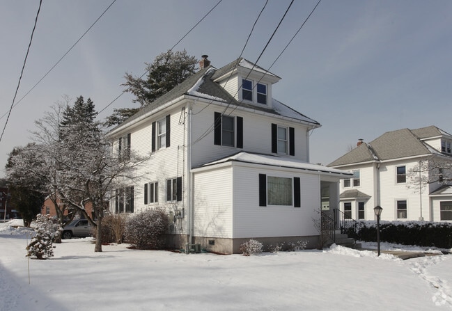
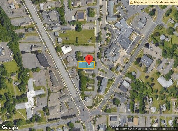
Property Record
48 Church St, Rocky Hill, CT 06067
NEARBY LISTINGS FOR SALE OR LEASE
Property Detail
48 Church St
ROCK-000010-000000-000022
Hartford
Officebuilding
Connecticut
X
22
09003C0517F
0.25 AC
2025
Rocky Hill
2025
Hartford
490100
Hartford-West Hartford-East Hartford, CT
1,482 SF
DEMOGRAPHICS near 48 Church St
1 Mile
3 Mile
5 Mile
2024 Total Population
6,622
37,366
106,869
2029 Population
6,699
37,452
106,275
Pop Growth 2024-2029
+ 1.16%
+ 0.23%
(0.56%)
Average Age
43
43
43
2024 Total Households
3,013
15,532
44,514
HH Growth 2024-2029
+ 1.13%
+ 0.30%
(0.59%)
Median Household Inc
$75,212
$100,052
$99,733
Avg Household Size
2.10
2.30
2.30
2024 Avg HH Vehicles
2.00
2.00
2.00
Median Home Value
$252,294
$302,134
$286,484
Median Year Built
1971
1969
1970
Nearby Places
Map Layers
Map Styles
 Street
 Aerial
- Restaurants
- Banks
- Shops
- Fitness
- Groceries
PUBLIC TRANSPORTATION
COMMUTER RAIL
DRIVE
WALK
Distance
14 min
8.7 mi
DRIVE
WALK
Distance
14 min
8.7 mi
AIRPORT
Bradley International
DRIVE
WALK
Distance
Bradley International
36 min
22.7 mi
Tweed/New Haven
DRIVE
WALK
Distance
Tweed/New Haven
51 min
34.2 mi
Freight Ports
Port of New Haven
DRIVE
WALK
Distance
Port of New Haven
45 min
33.1 mi
SALE & LEASE HISTORY
LISTING DATE
SALE/LEASE

May 16, 2023
For Lease
Nearby Properties
Address
Land Use
TOTAL SIZE
Lot Size
Zoning
Address
Land Use
TOTAL SIZE
Lot Size
Zoning
24.70 AC
R-20
Address
Land Use
TOTAL SIZE
Lot Size
Zoning
81,507 SF
21.60 AC
R-20
Address
Land Use
TOTAL SIZE
Lot Size
Zoning
117,178 SF
13.02 AC
R-20
Address
Land Use
TOTAL SIZE
Lot Size
Zoning
33.30 AC
R-20
Address
Land Use
TOTAL SIZE
Lot Size
Zoning
248,626 SF
92.26 AC
BP-2
Address
Land Use
TOTAL SIZE
Lot Size
Zoning
87,037 SF
10.44 AC
R-20
Address
Land Use
TOTAL SIZE
Lot Size
Zoning
Address
Land Use
TOTAL SIZE
Lot Size
Zoning
310,582 SF
32.72 AC
OP
Address
Land Use
TOTAL SIZE
Lot Size
Zoning
9.81 AC
OP
Address
Land Use
TOTAL SIZE
Lot Size
Zoning
1.99 AC
C
Address
Land Use
TOTAL SIZE
Lot Size
Zoning
9.09 AC
R-20
Address
Land Use
TOTAL SIZE
Lot Size
Zoning
188,427 SF
8.55 AC
SRD
Address
Land Use
TOTAL SIZE
Lot Size
Zoning
10.45 AC
R-20
Address
Land Use
TOTAL SIZE
Lot Size
Zoning
83,468 SF
6.65 AC
R-20
Address
Land Use
TOTAL SIZE
Lot Size
Zoning
Address
Land Use
TOTAL SIZE
Lot Size
Zoning
145,956 SF
11.27 AC
OP
Address
Land Use
TOTAL SIZE
Lot Size
Zoning
13.85 AC
R-20
Address
Land Use
TOTAL SIZE
Lot Size
Zoning
49,724 SF
9.02 AC
OP
Address
Land Use
TOTAL SIZE
Lot Size
Zoning
13.61 AC
RC
Address
Land Use
TOTAL SIZE
Lot Size
Zoning
8.56 AC
TC
Address
Land Use
TOTAL SIZE
Lot Size
Zoning
172,155 SF
57.35 AC
OP
Address
Land Use
TOTAL SIZE
Lot Size
Zoning
38.84 AC
RC
Address
Land Use
TOTAL SIZE
Lot Size
Zoning
15,395 SF
158.10 AC
R-25
Address
Land Use
TOTAL SIZE
Lot Size
Zoning
97.02 AC
A1
Address
Land Use
TOTAL SIZE
Lot Size
Zoning
57,862 SF
23.20 AC
AA
Address
Land Use
TOTAL SIZE
Lot Size
Zoning
135,562 SF
3.15 AC
RC
Address
Land Use
TOTAL SIZE
Lot Size
Zoning
85,262 SF
34.64 AC
Address
Land Use
TOTAL SIZE
Lot Size
Zoning
14.11 AC
C
Address
Land Use
TOTAL SIZE
Lot Size
Zoning
11.80 AC
R-20
Address
Land Use
TOTAL SIZE
Lot Size
Zoning
105,456 SF
11.91 AC
OP
The World's #1 Commercial Real Estate Marketplace
Connect with us
© 2025 CoStar Group
The information above has been obtained from sources believed reliable. While we do not doubt its accuracy we have not verified it and make no guarantee, warranty or representation about it. It is your responsibility to independently confirm its accuracy and completeness. Any projections, opinions, assumptions, or estimates used are for example only and do not represent the current or future performance of the property. The value of this transaction to you depends on tax and other factors which should be evaluated by your tax, financial, and legal advisors. You and your advisors should conduct a careful, independent investigation of the property to determine to your satisfaction the suitability of the property for your needs.