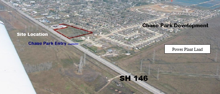
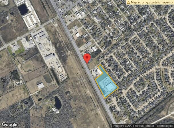
Property Record
4819 Highway 146, Bacliff, TX 77518
NEARBY LISTINGS FOR SALE OR LEASE
Property Detail
4819 Highway 146
Houston-The Woodlands-Sugar Land, TX
Hatch, A Survey
0088-0023-0000-000
ABST 88 A HATCH SUR TR 23 4.525 ACRS
Commercialnec
Galveston
X
Texas
48167C0255G
23
2024
4.53 AC
2023
Southeast Outlier
721703
Houston
20,150 SF
DEMOGRAPHICS near 4819 Highway 146
1 Mile
3 Mile
5 Mile
2024 Total Population
4,955
26,441
74,159
2029 Population
5,173
27,695
77,563
Pop Growth 2024-2029
+ 4.40%
+ 4.74%
+ 4.59%
Average Age
35
36
38
2024 Total Households
1,680
9,206
26,977
HH Growth 2024-2029
+ 4.70%
+ 5.02%
+ 4.85%
Median Household Inc
$56,686
$89,207
$96,243
Avg Household Size
2.80
2.80
2.70
2024 Avg HH Vehicles
2.00
2.00
2.00
Median Home Value
$152,511
$258,825
$267,809
Median Year Built
1987
1995
1995
Nearby Places
- Restaurants
- Banks
- Shops
- Fitness
- Groceries
PUBLIC TRANSPORTATION
AIRPORT
William P Hobby
DRIVE
WALK
Distance
William P Hobby
39 min
23.6 mi
Freight Ports
Port of Galveston
DRIVE
WALK
Distance
Port of Galveston
25 min
20.6 mi
SALE & LEASE HISTORY
LISTING DATE
SALE/LEASE

Jul 23, 2018
For Lease
Nearby Properties
Address
Land Use
TOTAL SIZE
Lot Size
Zoning
Address
Land Use
TOTAL SIZE
Lot Size
Zoning
500,000 SF
125.06 AC
Address
Land Use
TOTAL SIZE
Lot Size
Zoning
372,456 SF
20.15 AC
Address
Land Use
TOTAL SIZE
Lot Size
Zoning
228,100 SF
68.71 AC
Address
Land Use
TOTAL SIZE
Lot Size
Zoning
38.73 AC
Address
Land Use
TOTAL SIZE
Lot Size
Zoning
Address
Land Use
TOTAL SIZE
Lot Size
Zoning
182,020 SF
100.72 AC
Address
Land Use
TOTAL SIZE
Lot Size
Zoning
120,000 SF
23.14 AC
Address
Land Use
TOTAL SIZE
Lot Size
Zoning
105,218 SF
4.91 AC
Address
Land Use
TOTAL SIZE
Lot Size
Zoning
114,488 SF
20 AC
Address
Land Use
TOTAL SIZE
Lot Size
Zoning
336,091 SF
29.38 AC
NONE
Address
Land Use
TOTAL SIZE
Lot Size
Zoning
98,011 SF
15.09 AC
Address
Land Use
TOTAL SIZE
Lot Size
Zoning
95,882 SF
5.41 AC
Address
Land Use
TOTAL SIZE
Lot Size
Zoning
103,138 SF
4.84 AC
Address
Land Use
TOTAL SIZE
Lot Size
Zoning
167 SF
23.46 AC
Address
Land Use
TOTAL SIZE
Lot Size
Zoning
57,804 SF
3 AC
Address
Land Use
TOTAL SIZE
Lot Size
Zoning
33,788 SF
3.06 AC
Address
Land Use
TOTAL SIZE
Lot Size
Zoning
Address
Land Use
TOTAL SIZE
Lot Size
Zoning
102,155 SF
5 AC
Address
Land Use
TOTAL SIZE
Lot Size
Zoning
54,440 SF
4.75 AC
Address
Land Use
TOTAL SIZE
Lot Size
Zoning
105,600 SF
10.07 AC
Address
Land Use
TOTAL SIZE
Lot Size
Zoning
60,807 SF
12.26 AC
Address
Land Use
TOTAL SIZE
Lot Size
Zoning
137,088 SF
10.08 AC
Address
Land Use
TOTAL SIZE
Lot Size
Zoning
14,820 SF
1.98 AC
Address
Land Use
TOTAL SIZE
Lot Size
Zoning
11,076 SF
1.80 AC
Address
Land Use
TOTAL SIZE
Lot Size
Zoning
54,426 SF
3.40 AC
Address
Land Use
TOTAL SIZE
Lot Size
Zoning
99 SF
6.46 AC
Address
Land Use
TOTAL SIZE
Lot Size
Zoning
15,288 SF
1.43 AC
Address
Land Use
TOTAL SIZE
Lot Size
Zoning
5,950 SF
23.22 AC
Address
Land Use
TOTAL SIZE
Lot Size
Zoning
48,705 SF
2.75 AC
The World's #1 Commercial Real Estate Marketplace
Connect with us
© 2025 CoStar Group
The information above has been obtained from sources believed reliable. While we do not doubt its accuracy we have not verified it and make no guarantee, warranty or representation about it. It is your responsibility to independently confirm its accuracy and completeness. Any projections, opinions, assumptions, or estimates used are for example only and do not represent the current or future performance of the property. The value of this transaction to you depends on tax and other factors which should be evaluated by your tax, financial, and legal advisors. You and your advisors should conduct a careful, independent investigation of the property to determine to your satisfaction the suitability of the property for your needs.