Property Record
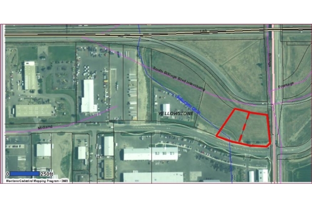
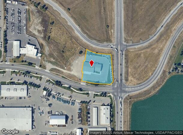
4819 Midland Rd, Billings, MT 59101
NEARBY LISTINGS FOR SALE OR LEASE
Property Detail
4819 Midland Rd
Billings, MT
Billings Operations Center Sub
03-0927-17-1-03-10-0000
BILLINGS OPERATIONS CENTER SUB, S17, T01 S, R26 E, BLOCK 1, LT 1A (19) AMD
Commercialnec
Yellowstone
X
Montana
30111C1460E
1a
2023
1.66 AC
2024
Billings
0009013054
Other Market Areas
11,600 SF
DEMOGRAPHICS near 4819 Midland Rd
1 Mile
3 Mile
5 Mile
2024 Total Population
4,649
49,119
94,188
2029 Population
5,049
53,115
101,979
Pop Growth 2024-2029
+ 8.60%
+ 8.14%
+ 8.27%
Average Age
38
39
41
2024 Total Households
1,899
21,437
40,732
HH Growth 2024-2029
+ 8.74%
+ 8.30%
+ 8.46%
Median Household Inc
$64,049
$57,447
$65,678
Avg Household Size
2.40
2.20
2.20
2024 Avg HH Vehicles
2.00
2.00
2.00
Median Home Value
$231,909
$245,063
$283,371
Median Year Built
1982
1964
1974
Nearby Places
- Restaurants
- Banks
- Shops
- Fitness
- Groceries
PUBLIC TRANSPORTATION
AIRPORT
Billings Logan International
Drive
Walk
Distance
Billings Logan International
26 min
8.7 mi
Freight Ports
Port of Everett
Drive
Walk
Distance
Port of Everett
881 min
839.5 mi
Nearby Properties
Address
Land Use
TOTAL SIZE
Lot Size
Zoning
Address
Land Use
TOTAL SIZE
Lot Size
Zoning
704701
9.06 AC
MCPZD
Address
Land Use
TOTAL SIZE
Lot Size
Zoning
141787
1.89 AC
Address
Land Use
TOTAL SIZE
Lot Size
Zoning
258977
18.05 AC
CI
Address
Land Use
TOTAL SIZE
Lot Size
Zoning
169281
11.41 AC
Address
Land Use
TOTAL SIZE
Lot Size
Zoning
198096
7.48 AC
MCPZD
Address
Land Use
TOTAL SIZE
Lot Size
Zoning
537468
36.83 AC
CC
Address
Land Use
TOTAL SIZE
Lot Size
Zoning
76098
0.80 AC
CBD
Address
Land Use
TOTAL SIZE
Lot Size
Zoning
118640
12.55 AC
P
Address
Land Use
TOTAL SIZE
Lot Size
Zoning
173807
11.56 AC
CI
Address
Land Use
TOTAL SIZE
Lot Size
Zoning
155084
13.78 AC
P
Address
Land Use
TOTAL SIZE
Lot Size
Zoning
136588
21.01 AC
CI
Address
Land Use
TOTAL SIZE
Lot Size
Zoning
177290
14.59 AC
HC
Address
Land Use
TOTAL SIZE
Lot Size
Zoning
0.80 AC
Address
Land Use
TOTAL SIZE
Lot Size
Zoning
218478
18.19 AC
CI
Address
Land Use
TOTAL SIZE
Lot Size
Zoning
0.72 AC
Address
Land Use
TOTAL SIZE
Lot Size
Zoning
149797
12.95 AC
CC
Address
Land Use
TOTAL SIZE
Lot Size
Zoning
108000
2.07 AC
CBD
Address
Land Use
TOTAL SIZE
Lot Size
Zoning
108563
4.38 AC
CBD
Address
Land Use
TOTAL SIZE
Lot Size
Zoning
188907
3.83 AC
CC
Address
Land Use
TOTAL SIZE
Lot Size
Zoning
172.22 AC
Address
Land Use
TOTAL SIZE
Lot Size
Zoning
87144
3.65 AC
PZD
Address
Land Use
TOTAL SIZE
Lot Size
Zoning
63650
4.13 AC
MCPZD
Address
Land Use
TOTAL SIZE
Lot Size
Zoning
205302
0.90 AC
CBD
Address
Land Use
TOTAL SIZE
Lot Size
Zoning
109485
8.87 AC
R-96
Address
Land Use
TOTAL SIZE
Lot Size
Zoning
167744
16.45 AC
CI
Address
Land Use
TOTAL SIZE
Lot Size
Zoning
409620
27.42 AC
CI
Address
Land Use
TOTAL SIZE
Lot Size
Zoning
141186
2.62 AC
CBD
Address
Land Use
TOTAL SIZE
Lot Size
Zoning
74990
0.59 AC
CBD
Address
Land Use
TOTAL SIZE
Lot Size
Zoning
213615
0.96 AC
CBD
Address
Land Use
TOTAL SIZE
Lot Size
Zoning
145168
0.96 AC
CBD
Start a new search to find other properties for sale or lease
Connect with us
© 2024 CoStar Group
The information above has been obtained from sources believed reliable. While we do not doubt its accuracy we have not verified it and make no guarantee, warranty or representation about it. It is your responsibility to independently confirm its accuracy and completeness. Any projections, opinions, assumptions, or estimates used are for example only and do not represent the current or future performance of the property. The value of this transaction to you depends on tax and other factors which should be evaluated by your tax, financial, and legal advisors. You and your advisors should conduct a careful, independent investigation of the property to determine to your satisfaction the suitability of the property for your needs.