Property Record
482 Blackburn Point Rd, Osprey, FL 34229
NEARBY LISTINGS FOR SALE OR LEASE
Property Detail
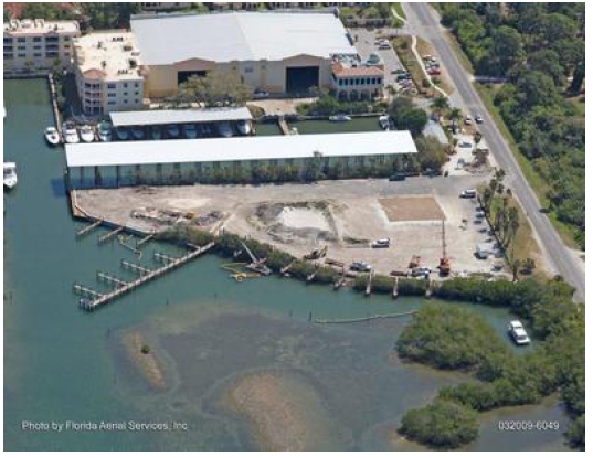
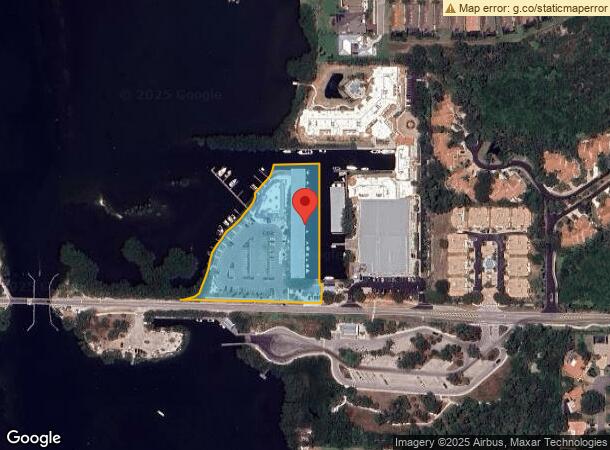
482 Blackburn Point Rd
0157-03-0001
Not Part Of A Subdivision
Marinafacility
COM NE COR SEC 15-38-18, TH N-89-50-40-W 2708.23 FT TH S 00-09-20 W 833.84 FT TH N 88-16-40 W 364.63 FT FOR POB TH N 02-02-10 E 65.65 FT TH N-88-16-40-W 9.1 FT TH N-0-09-20-E 418.94 FT TH
AE
Sarasota
12115C0236G
Florida
2023
3.38 AC
2024
Sarasota
002102
Tampa/St Petersburg
8,188 SF
North Port-Sarasota-Bradenton, FL
DEMOGRAPHICS near 482 Blackburn Point Rd
1 Mile
3 Mile
5 Mile
2024 Total Population
3,075
18,761
50,119
2029 Population
3,516
21,794
58,417
Pop Growth 2024-2029
+ 14.34%
+ 16.17%
+ 16.56%
Average Age
57
57
57
2024 Total Households
1,516
9,392
25,282
HH Growth 2024-2029
+ 14.31%
+ 16.24%
+ 16.64%
Median Household Inc
$79,104
$87,105
$83,041
Avg Household Size
2.00
1.90
1.90
2024 Avg HH Vehicles
2.00
2.00
2.00
Median Home Value
$559,315
$455,876
$419,091
Median Year Built
2001
1994
1991
Nearby Places
- Restaurants
- Banks
- Shops
- Fitness
- Groceries
PUBLIC TRANSPORTATION
AIRPORT
Sarasota/Bradenton International
DRIVE
WALK
Distance
Sarasota/Bradenton International
33 min
17.8 mi
Freight Ports
Port Manatee
DRIVE
WALK
Distance
Port Manatee
53 min
41.0 mi
Nearby Properties
Address
Land Use
TOTAL SIZE
Lot Size
Zoning
Address
Land Use
TOTAL SIZE
Lot Size
Zoning
8,017 SF
56 AC
RMH
Address
Land Use
TOTAL SIZE
Lot Size
Zoning
195,192 SF
73.19 AC
GU
Address
Land Use
TOTAL SIZE
Lot Size
Zoning
175,813 SF
10.09 AC
CG
Address
Land Use
TOTAL SIZE
Lot Size
Zoning
124,546 SF
76 AC
GU
Address
Land Use
TOTAL SIZE
Lot Size
Zoning
209,566 SF
18.63 AC
CG
Address
Land Use
TOTAL SIZE
Lot Size
Zoning
64,866 SF
426.09 AC
OUE2
Address
Land Use
TOTAL SIZE
Lot Size
Zoning
48.01 AC
RSF1
Address
Land Use
TOTAL SIZE
Lot Size
Zoning
12,263 SF
3.38 AC
RE2
Address
Land Use
TOTAL SIZE
Lot Size
Zoning
17,028 SF
3.57 AC
RE2
Address
Land Use
TOTAL SIZE
Lot Size
Zoning
12,552 SF
6.73 AC
RE2
Address
Land Use
TOTAL SIZE
Lot Size
Zoning
89,684 SF
2.42 AC
CG
Address
Land Use
TOTAL SIZE
Lot Size
Zoning
16,879 SF
8.60 AC
RE2
Address
Land Use
TOTAL SIZE
Lot Size
Zoning
8,407 SF
30.21 AC
RSF1
Address
Land Use
TOTAL SIZE
Lot Size
Zoning
118,522 SF
18.40 AC
RMF2
Address
Land Use
TOTAL SIZE
Lot Size
Zoning
74,091 SF
1.66 AC
CI
Address
Land Use
TOTAL SIZE
Lot Size
Zoning
88,509 SF
12.03 AC
CG
Address
Land Use
TOTAL SIZE
Lot Size
Zoning
8.14 AC
RMF3
Address
Land Use
TOTAL SIZE
Lot Size
Zoning
68,641 SF
6.40 AC
RTR
Address
Land Use
TOTAL SIZE
Lot Size
Zoning
16,033 SF
2 AC
RE1
Address
Land Use
TOTAL SIZE
Lot Size
Zoning
95,124 SF
1.79 AC
CG
Address
Land Use
TOTAL SIZE
Lot Size
Zoning
8,757 SF
2.61 AC
OUE2
Address
Land Use
TOTAL SIZE
Lot Size
Zoning
27,472 SF
8.36 AC
GU
Address
Land Use
TOTAL SIZE
Lot Size
Zoning
17,314 SF
1.71 AC
RE1
Address
Land Use
TOTAL SIZE
Lot Size
Zoning
897 SF
11.41 AC
GU
Address
Land Use
TOTAL SIZE
Lot Size
Zoning
3,172 SF
8.95 AC
RMH
Address
Land Use
TOTAL SIZE
Lot Size
Zoning
68,190 SF
4.13 AC
CG
Address
Land Use
TOTAL SIZE
Lot Size
Zoning
30,314 SF
20.28 AC
RSF1
Address
Land Use
TOTAL SIZE
Lot Size
Zoning
8,870 SF
2.99 AC
RE2
Address
Land Use
TOTAL SIZE
Lot Size
Zoning
8,732 SF
1.56 AC
RE1
The World's #1 Commercial Real Estate Marketplace
Connect with us
© 2025 CoStar Group
The information above has been obtained from sources believed reliable. While we do not doubt its accuracy we have not verified it and make no guarantee, warranty or representation about it. It is your responsibility to independently confirm its accuracy and completeness. Any projections, opinions, assumptions, or estimates used are for example only and do not represent the current or future performance of the property. The value of this transaction to you depends on tax and other factors which should be evaluated by your tax, financial, and legal advisors. You and your advisors should conduct a careful, independent investigation of the property to determine to your satisfaction the suitability of the property for your needs.