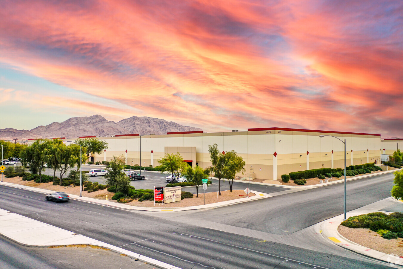
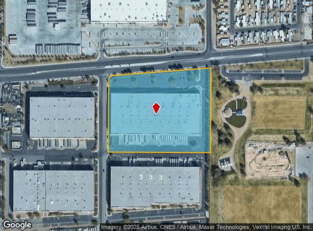
Property Record
4825 E Cheyenne Ave, Las Vegas, NV 89115

NEARBY LISTINGS FOR SALE OR LEASE
Property Detail
4825 E Cheyenne Ave
Las Vegas-Henderson-Paradise, NV
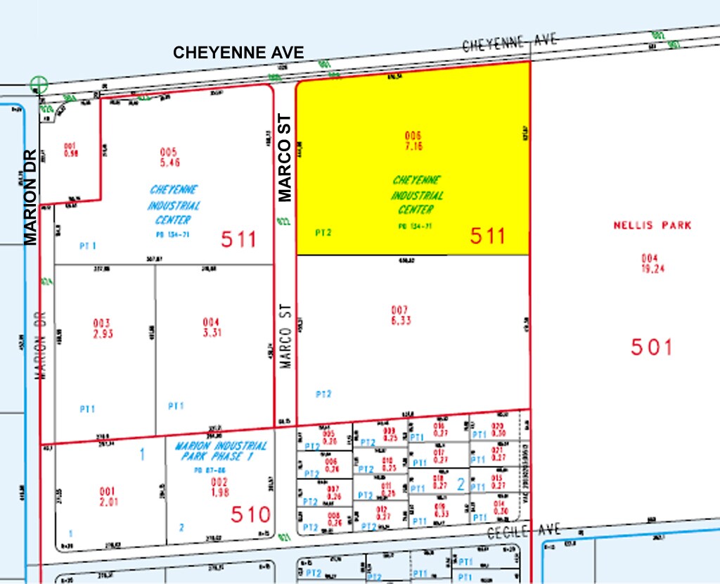
Cheyenne Indst Center
140-17-511-006
CHEYENNE INDST CENTER PLAT BOOK 134 PAGE 71 PT LOT 2
Shipyard
Clark
X
Nevada
32003C2179F
2
2024
7.16 AC
2024
North Las Vegas
007100
Las Vegas
137,161 SF
DEMOGRAPHICS near 4825 E Cheyenne Ave
1 Mile
3 Mile
5 Mile
2024 Total Population
7,122
153,879
356,555
2029 Population
7,930
164,366
381,203
Pop Growth 2024-2029
+ 11.35%
+ 6.82%
+ 6.91%
Average Age
33
33
35
2024 Total Households
2,547
45,118
110,439
HH Growth 2024-2029
+ 11.43%
+ 6.86%
+ 6.93%
Median Household Inc
$23,730
$42,587
$45,080
Avg Household Size
2.60
3.20
3.10
2024 Avg HH Vehicles
1.00
2.00
2.00
Median Home Value
$60,585
$228,860
$259,998
Median Year Built
1985
1987
1989
Nearby Places
- Restaurants
- Banks
- Shops
- Fitness
- Groceries
PUBLIC TRANSPORTATION
AIRPORT
Harry Reid International
DRIVE
WALK
Distance
Harry Reid International
25 min
15.3 mi
Boulder City Municipal
DRIVE
WALK
Distance
Boulder City Municipal
40 min
26.6 mi
Freight Ports
Port of Long Beach
DRIVE
WALK
Distance
Port of Long Beach
326 min
290.6 mi
SALE & LEASE HISTORY
LISTING DATE
SALE/LEASE

Mar 19, 2019
For Lease
Aug 11, 2017
For Lease
Nearby Properties
Address
Land Use
TOTAL SIZE
Lot Size
Zoning
Address
Land Use
TOTAL SIZE
Lot Size
Zoning
1,767,948 SF
142.04 AC
Address
Land Use
TOTAL SIZE
Lot Size
Zoning
90.41 AC
Address
Land Use
TOTAL SIZE
Lot Size
Zoning
1,102,891 SF
84.43 AC
Address
Land Use
TOTAL SIZE
Lot Size
Zoning
747,196 SF
40.03 AC
Address
Land Use
TOTAL SIZE
Lot Size
Zoning
632,224 SF
31.23 AC
Address
Land Use
TOTAL SIZE
Lot Size
Zoning
677,768 SF
31.52 AC
Address
Land Use
TOTAL SIZE
Lot Size
Zoning
15,566 SF
48.39 AC
R4
Address
Land Use
TOTAL SIZE
Lot Size
Zoning
617,670 SF
27.90 AC
M2
Address
Land Use
TOTAL SIZE
Lot Size
Zoning
546,249 SF
28.58 AC
Address
Land Use
TOTAL SIZE
Lot Size
Zoning
152,520 SF
42.31 AC
M2
Address
Land Use
TOTAL SIZE
Lot Size
Zoning
463,680 SF
13.81 AC
Address
Land Use
TOTAL SIZE
Lot Size
Zoning
513,240 SF
24.86 AC
M2
Address
Land Use
TOTAL SIZE
Lot Size
Zoning
350,494 SF
18.86 AC
RU
Address
Land Use
TOTAL SIZE
Lot Size
Zoning
29.35 AC
CV
Address
Land Use
TOTAL SIZE
Lot Size
Zoning
332,580 SF
15.70 AC
M2
Address
Land Use
TOTAL SIZE
Lot Size
Zoning
342,160 SF
37.72 AC
RT
Address
Land Use
TOTAL SIZE
Lot Size
Zoning
612,680 SF
25.48 AC
M2
Address
Land Use
TOTAL SIZE
Lot Size
Zoning
201,218 SF
36.38 AC
Address
Land Use
TOTAL SIZE
Lot Size
Zoning
20.91 AC
PF
Address
Land Use
TOTAL SIZE
Lot Size
Zoning
1,008 SF
31.47 AC
PF
Address
Land Use
TOTAL SIZE
Lot Size
Zoning
339,280 SF
18.19 AC
Address
Land Use
TOTAL SIZE
Lot Size
Zoning
4,441 SF
11.56 AC
M1
Address
Land Use
TOTAL SIZE
Lot Size
Zoning
258,424 SF
12.62 AC
Address
Land Use
TOTAL SIZE
Lot Size
Zoning
374,712 SF
18.88 AC
MD
Address
Land Use
TOTAL SIZE
Lot Size
Zoning
410,685 SF
20.50 AC
M2
Address
Land Use
TOTAL SIZE
Lot Size
Zoning
420,000 SF
21.23 AC
M1
Address
Land Use
TOTAL SIZE
Lot Size
Zoning
237,348 SF
12.92 AC
Address
Land Use
TOTAL SIZE
Lot Size
Zoning
392,040 SF
19.37 AC
M2
Address
Land Use
TOTAL SIZE
Lot Size
Zoning
282,204 SF
18 AC
MD
The World's #1 Commercial Real Estate Marketplace
Connect with us
© 2025 CoStar Group
The information above has been obtained from sources believed reliable. While we do not doubt its accuracy we have not verified it and make no guarantee, warranty or representation about it. It is your responsibility to independently confirm its accuracy and completeness. Any projections, opinions, assumptions, or estimates used are for example only and do not represent the current or future performance of the property. The value of this transaction to you depends on tax and other factors which should be evaluated by your tax, financial, and legal advisors. You and your advisors should conduct a careful, independent investigation of the property to determine to your satisfaction the suitability of the property for your needs.