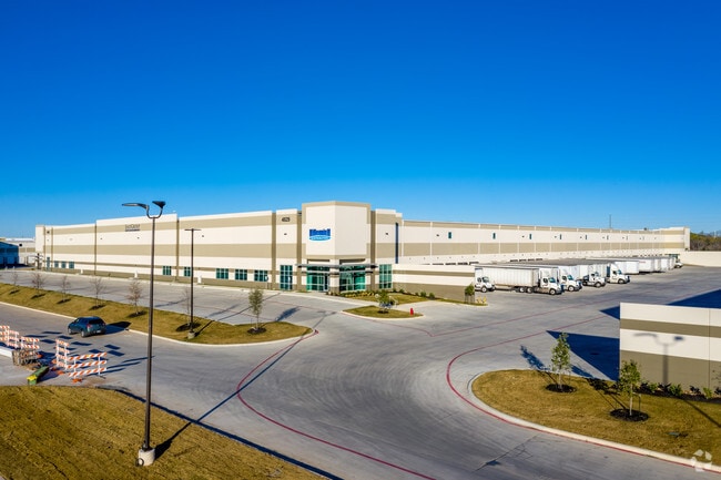
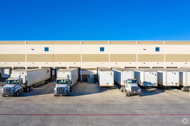
Property Record
4829 Eisenhauer Rd, San Antonio, TX 78218

NEARBY LISTINGS FOR SALE OR LEASE
Property Detail
4829 Eisenhauer Rd
San Antonio-New Braunfels, TX
Ncb 12190 (Eisenhauer Point Ut-3)
12190-000-0511
NCB 12190 (EISENHAUER POINT UT-3), LOT 51 DUPLICATE LEGAL TO PID 1256409 2018-CREATED PER PLAT 9713/139-151 FILED 03-22-2017
Warehouse
Bexar
X
Texas
48029C0407H
51
2024
25.69 AC
2025
Northeast
121403
San Antonio
328,605 SF
DEMOGRAPHICS near 4829 Eisenhauer Rd
1 Mile
3 Mile
5 Mile
2024 Total Population
11,688
105,424
264,806
2029 Population
12,379
112,200
282,038
Pop Growth 2024-2029
+ 5.91%
+ 6.43%
+ 6.51%
Average Age
38
37
37
2024 Total Households
4,513
39,829
98,871
HH Growth 2024-2029
+ 6.12%
+ 6.56%
+ 6.63%
Median Household Inc
$42,410
$51,390
$59,844
Avg Household Size
2.50
2.50
2.60
2024 Avg HH Vehicles
2.00
2.00
2.00
Median Home Value
$141,523
$175,615
$187,655
Median Year Built
1968
1979
1982
Nearby Places
Map Layers
Map Styles
 Street
 Aerial
- Restaurants
- Banks
- Shops
- Fitness
- Groceries
PUBLIC TRANSPORTATION
COMMUTER RAIL
San Antonio Amtrak Station (Sunset Limited - Amtrak, Texas Eagle - Amtrak)
DRIVE
WALK
Distance
San Antonio Amtrak Station (Sunset Limited - Amtrak, Texas Eagle - Amtrak)
15 min
9.3 mi
AIRPORT
San Antonio International
DRIVE
WALK
Distance
San Antonio International
12 min
6.6 mi
Freight Ports
Calhoun Port
DRIVE
WALK
Distance
Calhoun Port
180 min
147.2 mi
SALE & LEASE HISTORY
LISTING DATE
SALE/LEASE

May 15, 2018
For Lease
Nearby Properties
Address
Land Use
TOTAL SIZE
Lot Size
Zoning
Address
Land Use
TOTAL SIZE
Lot Size
Zoning
1,649,488 SF
70 AC
Address
Land Use
TOTAL SIZE
Lot Size
Zoning
25,513 SF
18.14 AC
Address
Land Use
TOTAL SIZE
Lot Size
Zoning
239,264 SF
9.02 AC
Address
Land Use
TOTAL SIZE
Lot Size
Zoning
278,406 SF
13.39 AC
Address
Land Use
TOTAL SIZE
Lot Size
Zoning
288,350 SF
13.01 AC
Address
Land Use
TOTAL SIZE
Lot Size
Zoning
268,495 SF
13.04 AC
Address
Land Use
TOTAL SIZE
Lot Size
Zoning
110,605 SF
19.95 AC
Address
Land Use
TOTAL SIZE
Lot Size
Zoning
157,762 SF
9.26 AC
Address
Land Use
TOTAL SIZE
Lot Size
Zoning
598,070 SF
46.05 AC
Address
Land Use
TOTAL SIZE
Lot Size
Zoning
457,302 SF
34.40 AC
Address
Land Use
TOTAL SIZE
Lot Size
Zoning
230,659 SF
15.48 AC
Address
Land Use
TOTAL SIZE
Lot Size
Zoning
279,012 SF
12.17 AC
Address
Land Use
TOTAL SIZE
Lot Size
Zoning
273,516 SF
17.50 AC
Address
Land Use
TOTAL SIZE
Lot Size
Zoning
132.44 AC
Address
Land Use
TOTAL SIZE
Lot Size
Zoning
92,859 SF
11.95 AC
Address
Land Use
TOTAL SIZE
Lot Size
Zoning
265,015 SF
12.81 AC
Address
Land Use
TOTAL SIZE
Lot Size
Zoning
337,468 SF
21.84 AC
Address
Land Use
TOTAL SIZE
Lot Size
Zoning
205,862 SF
10.79 AC
Address
Land Use
TOTAL SIZE
Lot Size
Zoning
275,327 SF
13.52 AC
Address
Land Use
TOTAL SIZE
Lot Size
Zoning
373,134 SF
16.29 AC
Address
Land Use
TOTAL SIZE
Lot Size
Zoning
222,865 SF
17.75 AC
Address
Land Use
TOTAL SIZE
Lot Size
Zoning
431,326 SF
42.70 AC
Address
Land Use
TOTAL SIZE
Lot Size
Zoning
300,555 SF
29.35 AC
Address
Land Use
TOTAL SIZE
Lot Size
Zoning
106,139 SF
5.84 AC
Address
Land Use
TOTAL SIZE
Lot Size
Zoning
257,263 SF
10.07 AC
Address
Land Use
TOTAL SIZE
Lot Size
Zoning
437,807 SF
24.55 AC
Address
Land Use
TOTAL SIZE
Lot Size
Zoning
391,863 SF
24.43 AC
Address
Land Use
TOTAL SIZE
Lot Size
Zoning
15.42 AC
Address
Land Use
TOTAL SIZE
Lot Size
Zoning
257,734 SF
5.57 AC
The World's #1 Commercial Real Estate Marketplace
Connect with us
© 2026 CoStar Group
The information above has been obtained from sources believed reliable. While we do not doubt its accuracy we have not verified it and make no guarantee, warranty or representation about it. It is your responsibility to independently confirm its accuracy and completeness. Any projections, opinions, assumptions, or estimates used are for example only and do not represent the current or future performance of the property. The value of this transaction to you depends on tax and other factors which should be evaluated by your tax, financial, and legal advisors. You and your advisors should conduct a careful, independent investigation of the property to determine to your satisfaction the suitability of the property for your needs.