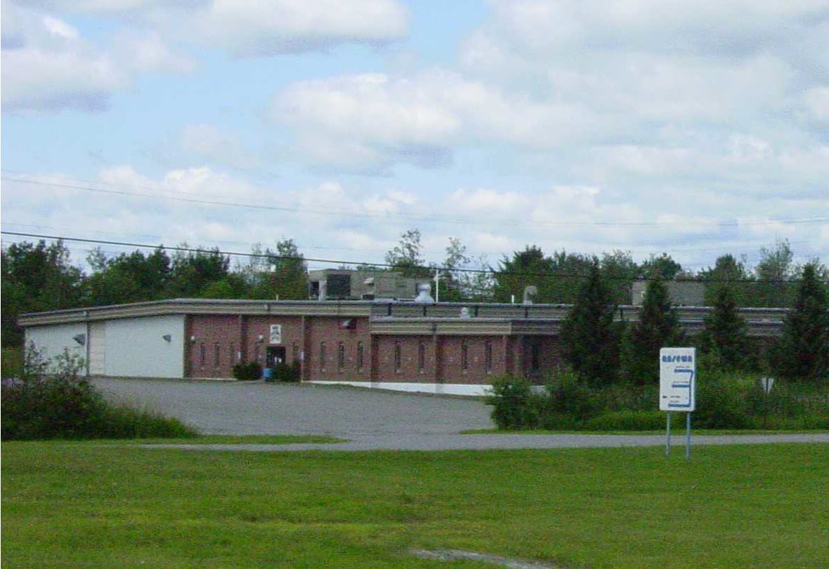
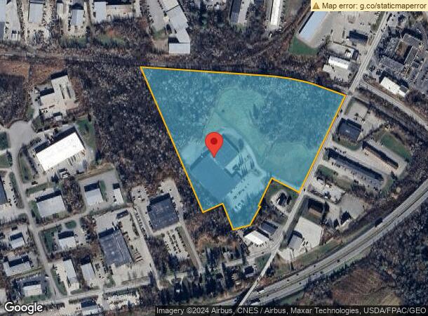
Property Record
489 Odlin Rd, Bangor, ME 04401
NEARBY LISTINGS FOR SALE OR LEASE
Property Detail
489 Odlin Rd
Warehouse
Penobscot
X
Maine
2301020015C
2-b
2024
27.56 AC
2024
Other Market Areas
000700
Bangor, ME
100,431 SF
BANG-000018R-000000-000002-B000000
DEMOGRAPHICS near 489 Odlin Rd
1 Mile
3 Mile
5 Mile
2024 Total Population
113
23,815
50,904
2029 Population
116
24,456
52,196
Pop Growth 2024-2029
+ 2.65%
+ 2.69%
+ 2.54%
Average Age
45
43
42
2024 Total Households
50
11,232
22,838
HH Growth 2024-2029
+ 4.00%
+ 2.90%
+ 2.68%
Median Household Inc
$52,143
$50,538
$55,845
Avg Household Size
2.00
2.00
2.10
2024 Avg HH Vehicles
2.00
1.00
2.00
Median Home Value
$174,999
$195,562
$212,056
Median Year Built
1947
1955
1967
Nearby Places
- Restaurants
- Banks
- Shops
- Fitness
- Groceries
PUBLIC TRANSPORTATION
AIRPORT
Bangor International
Drive
Walk
Distance
Bangor International
7 min
2.8 mi
Freight Ports
Searsport, ME
Drive
Walk
Distance
Searsport, ME
49 min
31.8 mi
SALE & LEASE HISTORY
LISTING DATE
SALE/LEASE

Sep 25, 2016
For Lease
Sep 23, 2016
For Sale
Dec 11, 2017
For Sale
Nearby Properties
Address
Land Use
TOTAL SIZE
Lot Size
Zoning
Address
Land Use
TOTAL SIZE
Lot Size
Zoning
466.65 AC
ADD
Address
Land Use
TOTAL SIZE
Lot Size
Zoning
186220
93.91 AC
G&SD
Address
Land Use
TOTAL SIZE
Lot Size
Zoning
609180
6.68 AC
USD
Address
Land Use
TOTAL SIZE
Lot Size
Zoning
Address
Land Use
TOTAL SIZE
Lot Size
Zoning
Address
Land Use
TOTAL SIZE
Lot Size
Zoning
6.37 AC
UID
Address
Land Use
TOTAL SIZE
Lot Size
Zoning
243694
2.95 AC
G&ISD
Address
Land Use
TOTAL SIZE
Lot Size
Zoning
87750
ADD
Address
Land Use
TOTAL SIZE
Lot Size
Zoning
400
3.44 AC
WDD
Address
Land Use
TOTAL SIZE
Lot Size
Zoning
100800
1.34 AC
DDD
Address
Land Use
TOTAL SIZE
Lot Size
Zoning
168615
19.44 AC
MDR-1
Address
Land Use
TOTAL SIZE
Lot Size
Zoning
12950
23.39 AC
31 - I
Address
Land Use
TOTAL SIZE
Lot Size
Zoning
38 AC
G&ISD
Address
Land Use
TOTAL SIZE
Lot Size
Zoning
Address
Land Use
TOTAL SIZE
Lot Size
Zoning
Address
Land Use
TOTAL SIZE
Lot Size
Zoning
115044
13.30 AC
G&ISD
Address
Land Use
TOTAL SIZE
Lot Size
Zoning
94081
17.56 AC
G&ISD
Address
Land Use
TOTAL SIZE
Lot Size
Zoning
94081
17.56 AC
G&ISD
Address
Land Use
TOTAL SIZE
Lot Size
Zoning
110031
3.81 AC
GC&S
Address
Land Use
TOTAL SIZE
Lot Size
Zoning
119930
9.50 AC
S&PS
Address
Land Use
TOTAL SIZE
Lot Size
Zoning
119930
9.50 AC
S&PS
Address
Land Use
TOTAL SIZE
Lot Size
Zoning
184000
16.43 AC
31 - I
Address
Land Use
TOTAL SIZE
Lot Size
Zoning
109507
1.96 AC
G&ISD
Address
Land Use
TOTAL SIZE
Lot Size
Zoning
7 AC
WDD
Address
Land Use
TOTAL SIZE
Lot Size
Zoning
7 AC
WDD
Address
Land Use
TOTAL SIZE
Lot Size
Zoning
144000
111.04 AC
32 - I
Address
Land Use
TOTAL SIZE
Lot Size
Zoning
32570
1.38 AC
G&ISD
Address
Land Use
TOTAL SIZE
Lot Size
Zoning
246766
22.44 AC
S&PS
Address
Land Use
TOTAL SIZE
Lot Size
Zoning
13.58 AC
Address
Land Use
TOTAL SIZE
Lot Size
Zoning
69703
7.92 AC
USD
Start a new search to find other properties for sale or lease
Connect with us
© 2024 CoStar Group
The information above has been obtained from sources believed reliable. While we do not doubt its accuracy we have not verified it and make no guarantee, warranty or representation about it. It is your responsibility to independently confirm its accuracy and completeness. Any projections, opinions, assumptions, or estimates used are for example only and do not represent the current or future performance of the property. The value of this transaction to you depends on tax and other factors which should be evaluated by your tax, financial, and legal advisors. You and your advisors should conduct a careful, independent investigation of the property to determine to your satisfaction the suitability of the property for your needs.