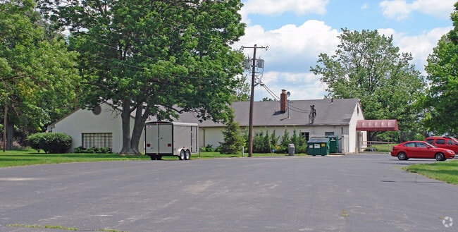
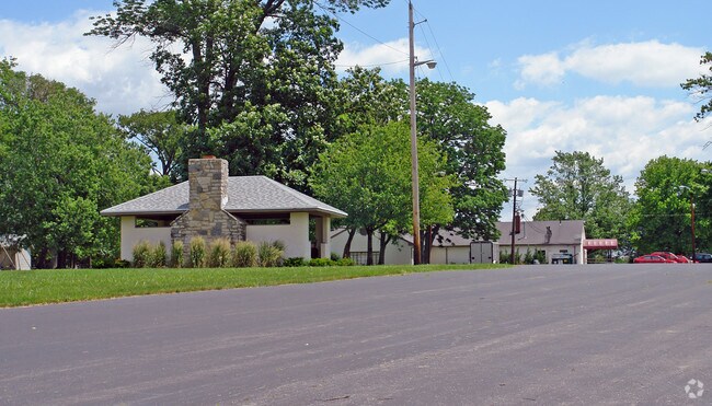
Property Record
490 Byers Rd, Miamisburg, OH 45342

NEARBY LISTINGS FOR SALE OR LEASE
Property Detail
490 Byers Rd
Dayton, OH
City/Miamisburg
K46-01004-0007
6551 1993 ANNEXATION
Industrialgeneral
Montgomery
X
Ohio
39113C0265E
7
2024
20.57 AC
2025
South Dayton
050503
Cincinnati/Dayton
5,098 SF
DEMOGRAPHICS near 490 Byers Rd
1 Mile
3 Mile
5 Mile
2024 Total Population
4,672
59,530
129,080
2029 Population
4,586
58,350
128,714
Pop Growth 2024-2029
(1.84%)
(1.98%)
(0.28%)
Average Age
39
42
42
2024 Total Households
2,483
26,575
55,041
HH Growth 2024-2029
(1.89%)
(2.05%)
(0.52%)
Median Household Inc
$46,725
$69,423
$74,658
Avg Household Size
1.80
2.20
2.30
2024 Avg HH Vehicles
1.00
2.00
2.00
Median Home Value
$204,054
$190,234
$214,750
Median Year Built
1978
1979
1977
Nearby Places
Map Layers
Map Styles
 Street
 Aerial
- Restaurants
- Banks
- Shops
- Fitness
- Groceries
PUBLIC TRANSPORTATION
AIRPORT
James M Cox Dayton International
DRIVE
WALK
Distance
James M Cox Dayton International
33 min
22.7 mi
SALE & LEASE HISTORY
LISTING DATE
SALE/LEASE

Sep 25, 2016
For Lease
Nearby Properties
Address
Land Use
TOTAL SIZE
Lot Size
Zoning
Address
Land Use
TOTAL SIZE
Lot Size
Zoning
25,715 SF
23.28 AC
Address
Land Use
TOTAL SIZE
Lot Size
Zoning
1,042,121 SF
51.37 AC
Address
Land Use
TOTAL SIZE
Lot Size
Zoning
Address
Land Use
TOTAL SIZE
Lot Size
Zoning
446,592 SF
4.33 AC
Address
Land Use
TOTAL SIZE
Lot Size
Zoning
47,552 SF
47.55 AC
Address
Land Use
TOTAL SIZE
Lot Size
Zoning
507,846 SF
23.90 AC
Address
Land Use
TOTAL SIZE
Lot Size
Zoning
6,204 SF
19.27 AC
Address
Land Use
TOTAL SIZE
Lot Size
Zoning
39,404 SF
55.59 AC
Address
Land Use
TOTAL SIZE
Lot Size
Zoning
2,304 SF
45.55 AC
Address
Land Use
TOTAL SIZE
Lot Size
Zoning
318,347 SF
26.75 AC
Address
Land Use
TOTAL SIZE
Lot Size
Zoning
203,556 SF
10.69 AC
Address
Land Use
TOTAL SIZE
Lot Size
Zoning
145,322 SF
22.31 AC
Address
Land Use
TOTAL SIZE
Lot Size
Zoning
129,932 SF
25.84 AC
Address
Land Use
TOTAL SIZE
Lot Size
Zoning
71,204 SF
5.15 AC
Address
Land Use
TOTAL SIZE
Lot Size
Zoning
66.56 AC
Address
Land Use
TOTAL SIZE
Lot Size
Zoning
1,042,121 SF
51.37 AC
Address
Land Use
TOTAL SIZE
Lot Size
Zoning
131,742 SF
7.75 AC
Address
Land Use
TOTAL SIZE
Lot Size
Zoning
89,683 SF
33.45 AC
Address
Land Use
TOTAL SIZE
Lot Size
Zoning
138,484 SF
23.04 AC
Address
Land Use
TOTAL SIZE
Lot Size
Zoning
24,928 SF
13.67 AC
Address
Land Use
TOTAL SIZE
Lot Size
Zoning
175,268 SF
14.03 AC
Address
Land Use
TOTAL SIZE
Lot Size
Zoning
64,364 SF
26.01 AC
Address
Land Use
TOTAL SIZE
Lot Size
Zoning
209,894 SF
5.41 AC
Address
Land Use
TOTAL SIZE
Lot Size
Zoning
155,702 SF
5.95 AC
Address
Land Use
TOTAL SIZE
Lot Size
Zoning
31.95 AC
Address
Land Use
TOTAL SIZE
Lot Size
Zoning
Address
Land Use
TOTAL SIZE
Lot Size
Zoning
90,769 SF
1.05 AC
Address
Land Use
TOTAL SIZE
Lot Size
Zoning
122,344 SF
2.17 AC
Address
Land Use
TOTAL SIZE
Lot Size
Zoning
70,234 SF
11.22 AC
Address
Land Use
TOTAL SIZE
Lot Size
Zoning
82,510 SF
12.79 AC
The World's #1 Commercial Real Estate Marketplace
Connect with us
© 2026 CoStar Group
The information above has been obtained from sources believed reliable. While we do not doubt its accuracy we have not verified it and make no guarantee, warranty or representation about it. It is your responsibility to independently confirm its accuracy and completeness. Any projections, opinions, assumptions, or estimates used are for example only and do not represent the current or future performance of the property. The value of this transaction to you depends on tax and other factors which should be evaluated by your tax, financial, and legal advisors. You and your advisors should conduct a careful, independent investigation of the property to determine to your satisfaction the suitability of the property for your needs.