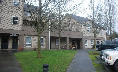
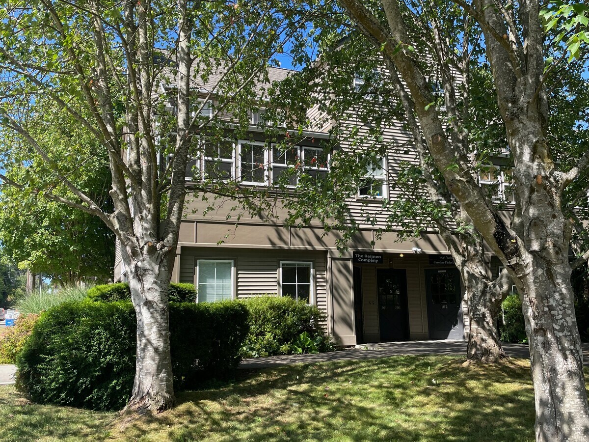
Property Record
490 Madison Ave N, Bainbridge Island, WA 98110
NEARBY LISTINGS FOR SALE OR LEASE
Property Detail
490 Madison Ave N
Bremerton-Silverdale, WA
Wyatts Corner
8106-000-105-02-08
UNIT 101B (A PORTION OF FORMER UNIT 101, WHICH WAS FORMERLY UNIT 105), WYATTS CORNER CONDOMINIUM, AS RECORDED IN VOLUME 5 OF CONDOMINIUMS, PAGES 126 - 130, INCLUSIVE, UNDER AUDITOR'S FILE NO. 9612170250, AMENDED IN VOLUME 7 OF CONDOMINIUMS, PAGES 23
Officecondo
Kitsap
X
Washington
53035C0244F
105
2025
3.32 AC
2025
Bainbridge Island
090900
Bremerton/Silverdale
1,584 SF
DEMOGRAPHICS near 490 Madison Ave N
1 Mile
3 Mile
5 Mile
2024 Total Population
7,761
17,938
37,199
2029 Population
7,923
18,179
37,403
Pop Growth 2024-2029
+ 2.09%
+ 1.34%
+ 0.55%
Average Age
49
48
45
2024 Total Households
3,613
7,498
14,736
HH Growth 2024-2029
+ 1.94%
+ 1.33%
+ 0.60%
Median Household Inc
$126,128
$153,325
$129,863
Avg Household Size
2.10
2.30
2.50
2024 Avg HH Vehicles
1.00
2.00
2.00
Median Home Value
$835,848
$934,469
$777,102
Median Year Built
1993
1989
1985
Nearby Places
- Restaurants
- Banks
- Shops
- Fitness
- Groceries
PUBLIC TRANSPORTATION
AIRPORT
Seattle Paine Field International
DRIVE
WALK
Distance
Seattle Paine Field International
79 min
33.0 mi
Freight Ports
Port of Seattle
DRIVE
WALK
Distance
Port of Seattle
91 min
43.3 mi
SALE & LEASE HISTORY
LISTING DATE
SALE/LEASE

Aug 09, 2024
For Sale
Nearby Properties
Address
Land Use
TOTAL SIZE
Lot Size
Zoning
Address
Land Use
TOTAL SIZE
Lot Size
Zoning
302,902 SF
0.32 AC
NC3-200 (M
Address
Land Use
TOTAL SIZE
Lot Size
Zoning
124,473 SF
1.40 AC
R-4.3
Address
Land Use
TOTAL SIZE
Lot Size
Zoning
3,872 SF
252.21 AC
R-0.4
Address
Land Use
TOTAL SIZE
Lot Size
Zoning
77,910 SF
4.62 AC
MAD
Address
Land Use
TOTAL SIZE
Lot Size
Zoning
7.01 AC
CITY
Address
Land Use
TOTAL SIZE
Lot Size
Zoning
73,500 SF
4.84 AC
R-2
Address
Land Use
TOTAL SIZE
Lot Size
Zoning
74,440 SF
4.36 AC
B/I
Address
Land Use
TOTAL SIZE
Lot Size
Zoning
11,520 SF
1.75 AC
MAD
Address
Land Use
TOTAL SIZE
Lot Size
Zoning
29,720 SF
2.75 AC
HS-2
Address
Land Use
TOTAL SIZE
Lot Size
Zoning
50,016 SF
1.14 AC
CORE
Address
Land Use
TOTAL SIZE
Lot Size
Zoning
36,113 SF
3.95 AC
ERICK
Address
Land Use
TOTAL SIZE
Lot Size
Zoning
52,942 SF
2.07 AC
CORE
Address
Land Use
TOTAL SIZE
Lot Size
Zoning
43,324 SF
1.54 AC
R-8
Address
Land Use
TOTAL SIZE
Lot Size
Zoning
26,768 SF
0.46 AC
HS-1
Address
Land Use
TOTAL SIZE
Lot Size
Zoning
1,422 SF
1.69 AC
NC
Address
Land Use
TOTAL SIZE
Lot Size
Zoning
924 SF
2.36 AC
B/I
Address
Land Use
TOTAL SIZE
Lot Size
Zoning
16,626 SF
5.59 AC
R-5
Address
Land Use
TOTAL SIZE
Lot Size
Zoning
46,266 SF
2.22 AC
R-8
Address
Land Use
TOTAL SIZE
Lot Size
Zoning
32,374 SF
4.31 AC
MAD
Address
Land Use
TOTAL SIZE
Lot Size
Zoning
38,032 SF
0.90 AC
R-8
Address
Land Use
TOTAL SIZE
Lot Size
Zoning
38,262 SF
1.01 AC
MAD
Address
Land Use
TOTAL SIZE
Lot Size
Zoning
31,936 SF
2.35 AC
MAD
Address
Land Use
TOTAL SIZE
Lot Size
Zoning
17,960 SF
0.51 AC
B/I
Address
Land Use
TOTAL SIZE
Lot Size
Zoning
460 SF
3.24 AC
R-4.3
Address
Land Use
TOTAL SIZE
Lot Size
Zoning
25,695 SF
2.02 AC
B/I
Address
Land Use
TOTAL SIZE
Lot Size
Zoning
12,475 SF
0.95 AC
CORE
Address
Land Use
TOTAL SIZE
Lot Size
Zoning
19,984 SF
7.35 AC
HS-1
Address
Land Use
TOTAL SIZE
Lot Size
Zoning
46,699 SF
7.35 AC
HS-1
Address
Land Use
TOTAL SIZE
Lot Size
Zoning
21,400 SF
4.97 AC
HS-2
Address
Land Use
TOTAL SIZE
Lot Size
Zoning
40,194 SF
1.71 AC
CORE
The World's #1 Commercial Real Estate Marketplace
Connect with us
© 2025 CoStar Group
The information above has been obtained from sources believed reliable. While we do not doubt its accuracy we have not verified it and make no guarantee, warranty or representation about it. It is your responsibility to independently confirm its accuracy and completeness. Any projections, opinions, assumptions, or estimates used are for example only and do not represent the current or future performance of the property. The value of this transaction to you depends on tax and other factors which should be evaluated by your tax, financial, and legal advisors. You and your advisors should conduct a careful, independent investigation of the property to determine to your satisfaction the suitability of the property for your needs.