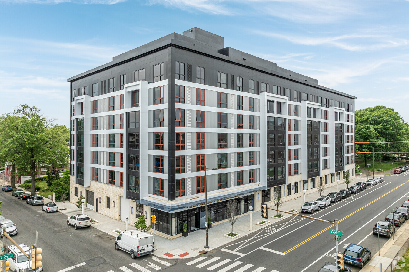
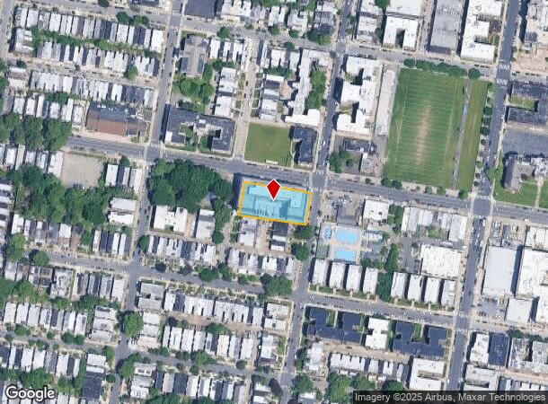
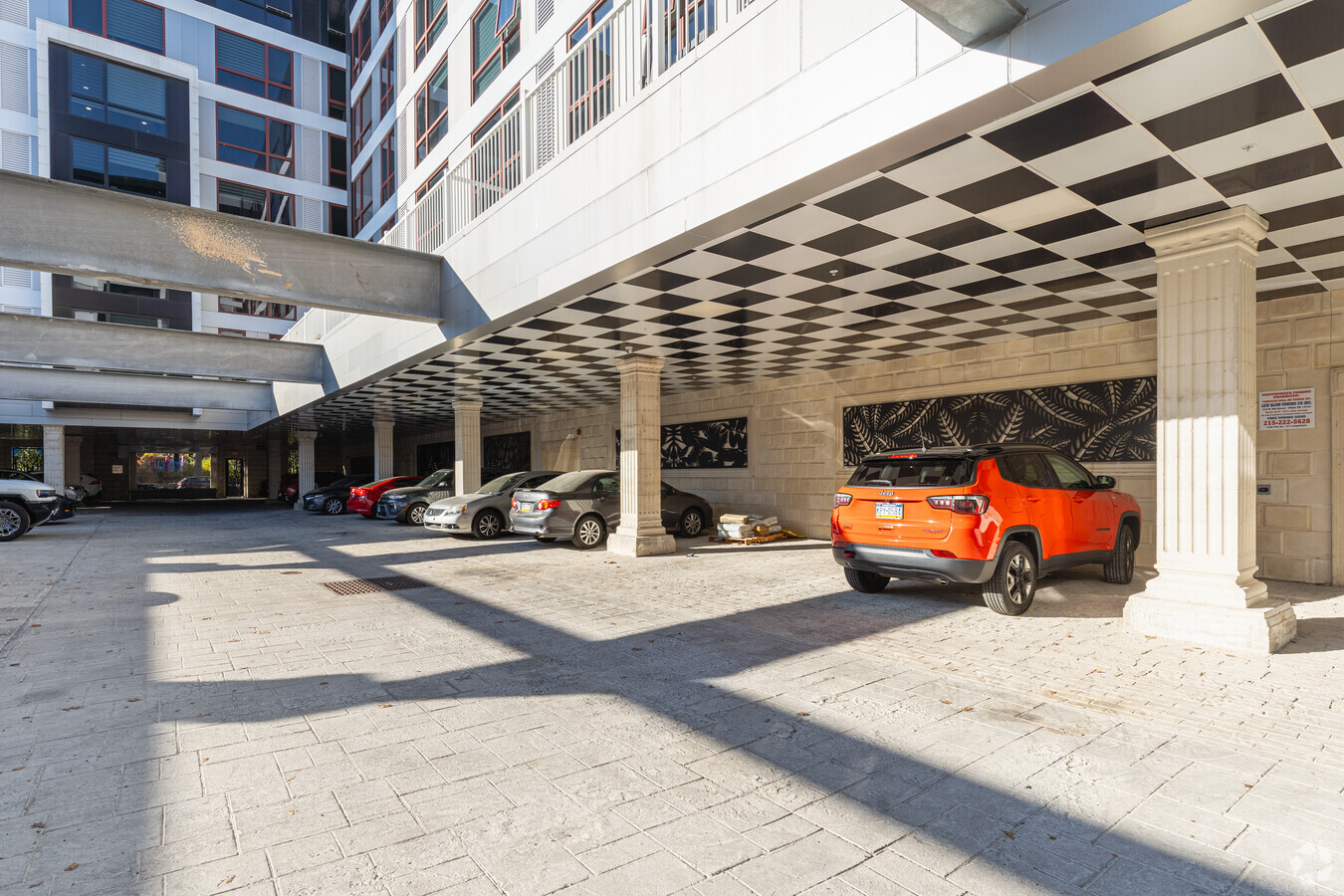
Property Record
4900 Spruce St, Philadelphia, PA 19139
NEARBY LISTINGS FOR SALE OR LEASE
Property Detail
4900 Spruce St
Philadelphia-Camden-Wilmington, PA-NJ-DE-MD
SWC 49TH ST TO
881000278
Philadelphia
Apartment
Pennsylvania
2024
0.57 AC
2025
Walnut Hill
008601
Philadelphia
180,000 SF
DEMOGRAPHICS near 4900 Spruce St
1 Mile
3 Mile
5 Mile
2024 Total Population
78,685
445,820
944,102
2029 Population
76,514
435,224
926,330
Pop Growth 2024-2029
(2.76%)
(2.38%)
(1.88%)
Average Age
36
37
37
2024 Total Households
33,549
188,470
397,861
HH Growth 2024-2029
(3.03%)
(2.68%)
(2.16%)
Median Household Inc
$42,163
$51,364
$59,287
Avg Household Size
2.20
2.20
2.20
2024 Avg HH Vehicles
1.00
1.00
1.00
Median Home Value
$174,575
$195,765
$250,886
Median Year Built
1947
1948
1949
Nearby Places
- Restaurants
- Banks
- Shops
- Fitness
- Groceries
PUBLIC TRANSPORTATION
TRANSIT/SUBWAY
Baltimore Avenue And 49Th Street (Route 34 - Southeastern Pennsylvania Transportation Authority Rapid Transit (SEPTA Subway & Trolley))
DRIVE
WALK
Distance
Baltimore Avenue And 49Th Street (Route 34 - Southeastern Pennsylvania Transportation Authority Rapid Transit (SEPTA Subway & Trolley))
1 min
8 min
0.4 mi
Baltimore Avenue And 48Th Street (Route 34 - Southeastern Pennsylvania Transportation Authority Rapid Transit (SEPTA Subway & Trolley))
DRIVE
WALK
Distance
Baltimore Avenue And 48Th Street (Route 34 - Southeastern Pennsylvania Transportation Authority Rapid Transit (SEPTA Subway & Trolley))
1 min
9 min
0.5 mi
Baltimore Avenue And 50Th Street (Route 34 - Southeastern Pennsylvania Transportation Authority Rapid Transit (SEPTA Subway & Trolley))
DRIVE
WALK
Distance
Baltimore Avenue And 50Th Street (Route 34 - Southeastern Pennsylvania Transportation Authority Rapid Transit (SEPTA Subway & Trolley))
1 min
9 min
0.5 mi
Baltimore Avenue And 47Th Street (Route 34 - Southeastern Pennsylvania Transportation Authority Rapid Transit (SEPTA Subway & Trolley))
DRIVE
WALK
Distance
Baltimore Avenue And 47Th Street (Route 34 - Southeastern Pennsylvania Transportation Authority Rapid Transit (SEPTA Subway & Trolley))
1 min
10 min
0.6 mi
Baltimore Ave & 46Th St (Route 34 - Southeastern Pennsylvania Transportation Authority Rapid Transit (SEPTA Subway & Trolley))
DRIVE
WALK
Distance
Baltimore Ave & 46Th St (Route 34 - Southeastern Pennsylvania Transportation Authority Rapid Transit (SEPTA Subway & Trolley))
1 min
12 min
0.6 mi
COMMUTER RAIL
49Th Street (R3 - Southeastern Pennsylvania Transportation Authority Regional Rail (SEPTA Regional Rail))
DRIVE
WALK
Distance
49Th Street (R3 - Southeastern Pennsylvania Transportation Authority Regional Rail (SEPTA Regional Rail))
2 min
17 min
0.8 mi
Angora (R3 - Southeastern Pennsylvania Transportation Authority Regional Rail (SEPTA Regional Rail))
DRIVE
WALK
Distance
Angora (R3 - Southeastern Pennsylvania Transportation Authority Regional Rail (SEPTA Regional Rail))
5 min
1.8 mi
AIRPORT
Philadelphia International
DRIVE
WALK
Distance
Philadelphia International
19 min
7.8 mi
Freight Ports
South Jersey Port
DRIVE
WALK
Distance
South Jersey Port
16 min
7.8 mi
SALE & LEASE HISTORY
LISTING DATE
SALE/LEASE

Nov 07, 2023
For Sale
Nearby Properties
Address
Land Use
TOTAL SIZE
Lot Size
Zoning
Address
Land Use
TOTAL SIZE
Lot Size
Zoning
1,449,928 SF
1.22 AC
CMX5
Address
Land Use
TOTAL SIZE
Lot Size
Zoning
1,076,400 SF
5 AC
CMX4
Address
Land Use
TOTAL SIZE
Lot Size
Zoning
1,200,021 SF
0.69 AC
CMX5
Address
Land Use
TOTAL SIZE
Lot Size
Zoning
26,690 SF
500 AC
SPINS
Address
Land Use
TOTAL SIZE
Lot Size
Zoning
1,103,300 SF
1.18 AC
CMX5
Address
Land Use
TOTAL SIZE
Lot Size
Zoning
1,464,000 SF
0.76 AC
CMX5
Address
Land Use
TOTAL SIZE
Lot Size
Zoning
319,590 SF
0.87 AC
I2
Address
Land Use
TOTAL SIZE
Lot Size
Zoning
760,635 SF
0.77 AC
CMX5
Address
Land Use
TOTAL SIZE
Lot Size
Zoning
1,179,072 SF
8.90 AC
RM4
Address
Land Use
TOTAL SIZE
Lot Size
Zoning
782,208 SF
0.68 AC
CMX5
Address
Land Use
TOTAL SIZE
Lot Size
Zoning
2,215,276 SF
2.46 AC
CMX5
Address
Land Use
TOTAL SIZE
Lot Size
Zoning
1,200,000 SF
1.78 AC
CMX5
Address
Land Use
TOTAL SIZE
Lot Size
Zoning
468,307 SF
2.45 AC
CMX4
Address
Land Use
TOTAL SIZE
Lot Size
Zoning
500,165 SF
2.16 AC
SPPOA
Address
Land Use
TOTAL SIZE
Lot Size
Zoning
1,152,520 SF
1.49 AC
CMX5
Address
Land Use
TOTAL SIZE
Lot Size
Zoning
696,920 SF
10.55 AC
SPINS
Address
Land Use
TOTAL SIZE
Lot Size
Zoning
1,152,480 SF
1.48 AC
CMX5
Address
Land Use
TOTAL SIZE
Lot Size
Zoning
1,143,040 SF
0.81 AC
CMX5
Address
Land Use
TOTAL SIZE
Lot Size
Zoning
700,000 SF
7.88 AC
CMX5
Address
Land Use
TOTAL SIZE
Lot Size
Zoning
738,207 SF
0.89 AC
CMX5
Address
Land Use
TOTAL SIZE
Lot Size
Zoning
677,140 SF
0.53 AC
CMX5
Address
Land Use
TOTAL SIZE
Lot Size
Zoning
803,012 SF
0.87 AC
CMX5
Address
Land Use
TOTAL SIZE
Lot Size
Zoning
626,685 SF
0.91 AC
CMX5
Address
Land Use
TOTAL SIZE
Lot Size
Zoning
1,183,616 SF
1.39 AC
CMX5
Address
Land Use
TOTAL SIZE
Lot Size
Zoning
780,000 SF
0.52 AC
CMX5
Address
Land Use
TOTAL SIZE
Lot Size
Zoning
391,440 SF
1.72 AC
SPINS
Address
Land Use
TOTAL SIZE
Lot Size
Zoning
904,000 SF
8.68 AC
SPINS
Address
Land Use
TOTAL SIZE
Lot Size
Zoning
600,523 SF
1.85 AC
CMX4
Address
Land Use
TOTAL SIZE
Lot Size
Zoning
385,000 SF
2.49 AC
SPINS
Address
Land Use
TOTAL SIZE
Lot Size
Zoning
376,874 SF
3.14 AC
SPINS
The World's #1 Commercial Real Estate Marketplace
Connect with us
© 2025 CoStar Group
The information above has been obtained from sources believed reliable. While we do not doubt its accuracy we have not verified it and make no guarantee, warranty or representation about it. It is your responsibility to independently confirm its accuracy and completeness. Any projections, opinions, assumptions, or estimates used are for example only and do not represent the current or future performance of the property. The value of this transaction to you depends on tax and other factors which should be evaluated by your tax, financial, and legal advisors. You and your advisors should conduct a careful, independent investigation of the property to determine to your satisfaction the suitability of the property for your needs.