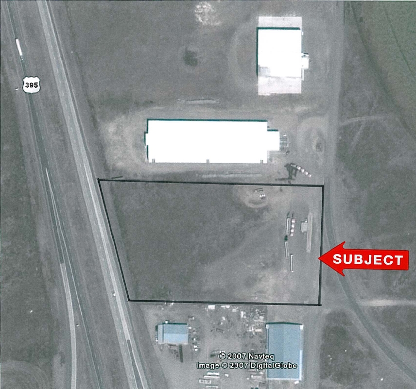
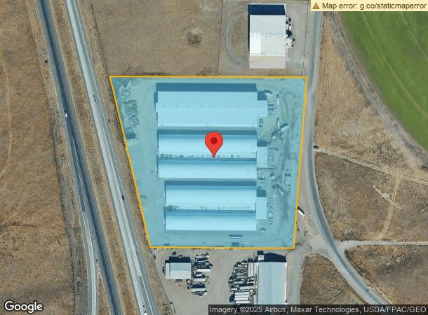
Property Record
4902 N Capitol Ave, Pasco, WA 99301
NEARBY LISTINGS FOR SALE OR LEASE
Property Detail
4902 N Capitol Ave
Kennewick-Richland, WA
Survey 528027 A
113-130-474
PTN SE4SW4 8-9-30 DAF: BEG AT S4 COR SD SEC; TH N89D23W ALG S LN SD SW4, 30.07 TO PT ON W LN OF E30 OF SD SW4, BEING THE TPOB; TH CONT N89D23W, 554.15 TO ELY R/W HWY395; TH N13D18W ALG R/W, 678.4; TH S89D28E, 761.55 TO PT ON W LN OF E30 OF
Agriculturalland
Franklin
2024
Washington
2023
9.95 AC
0201001000
Yakima/Kennewick
185,287 SF
Other Market Areas
DEMOGRAPHICS near 4902 N Capitol Ave
1 Mile
3 Mile
5 Mile
2024 Total Population
33
28,816
72,810
2029 Population
36
31,152
78,823
Pop Growth 2024-2029
+ 9.09%
+ 8.11%
+ 8.26%
Average Age
28
33
34
2024 Total Households
8
8,218
22,204
HH Growth 2024-2029
+ 12.50%
+ 8.14%
+ 8.27%
Median Household Inc
$39,999
$67,075
$75,429
Avg Household Size
4.10
3.40
3.20
2024 Avg HH Vehicles
2.00
2.00
2.00
Median Home Value
$199,999
$212,775
$274,563
Median Year Built
1997
1973
1987
Nearby Places
- Restaurants
- Banks
- Shops
- Fitness
- Groceries
PUBLIC TRANSPORTATION
COMMUTER RAIL
Pasco Amtrak Station (Empire Builder - Amtrak)
DRIVE
WALK
Distance
Pasco Amtrak Station (Empire Builder - Amtrak)
9 min
4.7 mi
AIRPORT
Tri-Cities
DRIVE
WALK
Distance
Tri-Cities
10 min
5.0 mi
Freight Ports
Port of Tacoma
DRIVE
WALK
Distance
Port of Tacoma
277 min
240.7 mi
Nearby Properties
Address
Land Use
TOTAL SIZE
Lot Size
Zoning
Address
Land Use
TOTAL SIZE
Lot Size
Zoning
1,078,419 SF
114.48 AC
Address
Land Use
TOTAL SIZE
Lot Size
Zoning
32.48 AC
Address
Land Use
TOTAL SIZE
Lot Size
Zoning
53,980 SF
25.90 AC
Address
Land Use
TOTAL SIZE
Lot Size
Zoning
277,478 SF
27.86 AC
Address
Land Use
TOTAL SIZE
Lot Size
Zoning
375,317 SF
17.68 AC
Address
Land Use
TOTAL SIZE
Lot Size
Zoning
444,084 SF
58 AC
Address
Land Use
TOTAL SIZE
Lot Size
Zoning
189,054 SF
28.48 AC
Address
Land Use
TOTAL SIZE
Lot Size
Zoning
160,930 SF
39.50 AC
Address
Land Use
TOTAL SIZE
Lot Size
Zoning
161,465 SF
24.12 AC
Address
Land Use
TOTAL SIZE
Lot Size
Zoning
214,102 SF
9.88 AC
Address
Land Use
TOTAL SIZE
Lot Size
Zoning
163,900 SF
11.90 AC
Address
Land Use
TOTAL SIZE
Lot Size
Zoning
153,320 SF
7.37 AC
Address
Land Use
TOTAL SIZE
Lot Size
Zoning
35,284 SF
30.53 AC
Address
Land Use
TOTAL SIZE
Lot Size
Zoning
174,890 SF
33.52 AC
Address
Land Use
TOTAL SIZE
Lot Size
Zoning
64,936 SF
Address
Land Use
TOTAL SIZE
Lot Size
Zoning
278,800 SF
110.64 AC
Address
Land Use
TOTAL SIZE
Lot Size
Zoning
110,458 SF
20 AC
Address
Land Use
TOTAL SIZE
Lot Size
Zoning
241,912 SF
12.99 AC
Address
Land Use
TOTAL SIZE
Lot Size
Zoning
88,510 SF
14.04 AC
Address
Land Use
TOTAL SIZE
Lot Size
Zoning
103,750 SF
14.97 AC
Address
Land Use
TOTAL SIZE
Lot Size
Zoning
80,604 SF
4.30 AC
Address
Land Use
TOTAL SIZE
Lot Size
Zoning
125,508 SF
3.50 AC
Address
Land Use
TOTAL SIZE
Lot Size
Zoning
75,542 SF
6.36 AC
Address
Land Use
TOTAL SIZE
Lot Size
Zoning
33,680 SF
2.60 AC
Address
Land Use
TOTAL SIZE
Lot Size
Zoning
96,442 SF
7.46 AC
Address
Land Use
TOTAL SIZE
Lot Size
Zoning
43,449 SF
6.58 AC
Address
Land Use
TOTAL SIZE
Lot Size
Zoning
56,696 SF
2.11 AC
Address
Land Use
TOTAL SIZE
Lot Size
Zoning
95,680 SF
12.59 AC
Address
Land Use
TOTAL SIZE
Lot Size
Zoning
58,701 SF
11.34 AC
Address
Land Use
TOTAL SIZE
Lot Size
Zoning
100,000 SF
5.26 AC
The World's #1 Commercial Real Estate Marketplace
Connect with us
© 2025 CoStar Group
The information above has been obtained from sources believed reliable. While we do not doubt its accuracy we have not verified it and make no guarantee, warranty or representation about it. It is your responsibility to independently confirm its accuracy and completeness. Any projections, opinions, assumptions, or estimates used are for example only and do not represent the current or future performance of the property. The value of this transaction to you depends on tax and other factors which should be evaluated by your tax, financial, and legal advisors. You and your advisors should conduct a careful, independent investigation of the property to determine to your satisfaction the suitability of the property for your needs.