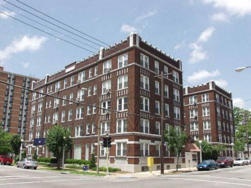
Property Record
4907 W Pine Blvd, Saint Louis, MO 63108
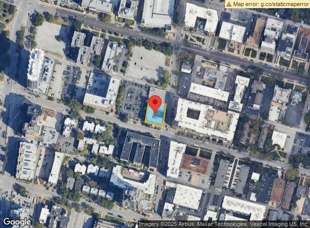
NEARBY LISTINGS FOR SALE OR LEASE
Property Detail
4907 W Pine Blvd
3883-00-0060-0
Lindell 2Nd Addn
Multifamilydwelling
C. B. 3883 W PINE 115 FT/105 FT X 140 FT/137 FT LINDELL 2ND ADDN BD E-EUCLID AVE
X
St. Louis City
2903850050C
Missouri
2023
0.35 AC
2024
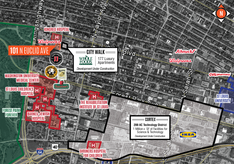
Central West End
112400
St. Louis
51,975 SF
St. Louis, MO-IL
DEMOGRAPHICS near 4907 W Pine Blvd
1 Mile
3 Mile
5 Mile
2024 Total Population
18,722
142,474
350,395
2029 Population
17,635
137,348
337,064
Pop Growth 2024-2029
(5.81%)
(3.60%)
(3.80%)
Average Age
39
38
39
2024 Total Households
10,756
66,593
164,195
HH Growth 2024-2029
(5.86%)
(3.96%)
(4.02%)
Median Household Inc
$55,877
$50,526
$53,028
Avg Household Size
1.60
1.90
2.00
2024 Avg HH Vehicles
1.00
1.00
1.00
Median Home Value
$335,614
$208,452
$195,286
Median Year Built
1948
1947
1947
Nearby Places
- Restaurants
- Banks
- Shops
- Fitness
- Groceries
PUBLIC TRANSPORTATION
COMMUTER RAIL
Central West End (Lambert Airport Shiloh-Scott - St. Louis MetroLink (MetroLink), Shrewsbury-Lansdowne I-44 Emerson Park - St. Louis MetroLink (MetroLink))
DRIVE
WALK
Distance
Central West End (Lambert Airport Shiloh-Scott - St. Louis MetroLink (MetroLink), Shrewsbury-Lansdowne I-44 Emerson Park - St. Louis MetroLink (MetroLink))
2 min
9 min
0.5 mi
Cortex Metrolink Station (MetroLink Blue Line - Metro St. Louis)
DRIVE
WALK
Distance
Cortex Metrolink Station (MetroLink Blue Line - Metro St. Louis)
2 min
19 min
1.0 mi
AIRPORT
St Louis Lambert International
DRIVE
WALK
Distance
St Louis Lambert International
20 min
10.9 mi
Scott AFB/Midamerica St Louis
DRIVE
WALK
Distance
Scott AFB/Midamerica St Louis
46 min
29.7 mi
Freight Ports
Port Milwaukee
DRIVE
WALK
Distance
Port Milwaukee
425 min
374.0 mi
SALE & LEASE HISTORY
LISTING DATE
SALE/LEASE

Sep 24, 2016
For Lease
Jan 16, 2018
For Lease
Nearby Properties
Address
Land Use
TOTAL SIZE
Lot Size
Zoning
Address
Land Use
TOTAL SIZE
Lot Size
Zoning
684,846 SF
90.65 AC
R6
Address
Land Use
TOTAL SIZE
Lot Size
Zoning
136.92 AC
AI
Address
Land Use
TOTAL SIZE
Lot Size
Zoning
833,982 SF
18.70 AC
GB
Address
Land Use
TOTAL SIZE
Lot Size
Zoning
558,158 SF
45.66 AC
14R-2
Address
Land Use
TOTAL SIZE
Lot Size
Zoning
152.06 AC
L
Address
Land Use
TOTAL SIZE
Lot Size
Zoning
1.72 AC
I
Address
Land Use
TOTAL SIZE
Lot Size
Zoning
1,361,485 SF
5.45 AC
E
Address
Land Use
TOTAL SIZE
Lot Size
Zoning
160,931 SF
141.53 AC
NU
Address
Land Use
TOTAL SIZE
Lot Size
Zoning
229.57 AC
B
Address
Land Use
TOTAL SIZE
Lot Size
Zoning
7,389 SF
68.80 AC
14R-2
Address
Land Use
TOTAL SIZE
Lot Size
Zoning
10.97 AC
I
Address
Land Use
TOTAL SIZE
Lot Size
Zoning
624,049 SF
20.78 AC
K
Address
Land Use
TOTAL SIZE
Lot Size
Zoning
7.94 AC
D
Address
Land Use
TOTAL SIZE
Lot Size
Zoning
739,544 SF
5.59 AC
H
Address
Land Use
TOTAL SIZE
Lot Size
Zoning
423,303 SF
9.97 AC
H
Address
Land Use
TOTAL SIZE
Lot Size
Zoning
1,089,750 SF
8.43 AC
I
Address
Land Use
TOTAL SIZE
Lot Size
Zoning
246,345 SF
4.17 AC
J
Address
Land Use
TOTAL SIZE
Lot Size
Zoning
1.98 AC
H
Address
Land Use
TOTAL SIZE
Lot Size
Zoning
Address
Land Use
TOTAL SIZE
Lot Size
Zoning
306,459 SF
4.79 AC
H
Address
Land Use
TOTAL SIZE
Lot Size
Zoning
7,780 SF
15.61 AC
14R-2
Address
Land Use
TOTAL SIZE
Lot Size
Zoning
225,920 SF
2.02 AC
H
Address
Land Use
TOTAL SIZE
Lot Size
Zoning
191,584 SF
1.76 AC
K
Address
Land Use
TOTAL SIZE
Lot Size
Zoning
15.27 AC
A
Address
Land Use
TOTAL SIZE
Lot Size
Zoning
358,243 SF
3.02 AC
H
Address
Land Use
TOTAL SIZE
Lot Size
Zoning
248,809 SF
3.22 AC
H
Address
Land Use
TOTAL SIZE
Lot Size
Zoning
309,734 SF
3.41 AC
E
Address
Land Use
TOTAL SIZE
Lot Size
Zoning
8.54 AC
H
Address
Land Use
TOTAL SIZE
Lot Size
Zoning
191,352 SF
4.41 AC
K
Address
Land Use
TOTAL SIZE
Lot Size
Zoning
112,656 SF
3.55 AC
HK
The World's #1 Commercial Real Estate Marketplace
Connect with us
© 2025 CoStar Group
The information above has been obtained from sources believed reliable. While we do not doubt its accuracy we have not verified it and make no guarantee, warranty or representation about it. It is your responsibility to independently confirm its accuracy and completeness. Any projections, opinions, assumptions, or estimates used are for example only and do not represent the current or future performance of the property. The value of this transaction to you depends on tax and other factors which should be evaluated by your tax, financial, and legal advisors. You and your advisors should conduct a careful, independent investigation of the property to determine to your satisfaction the suitability of the property for your needs.