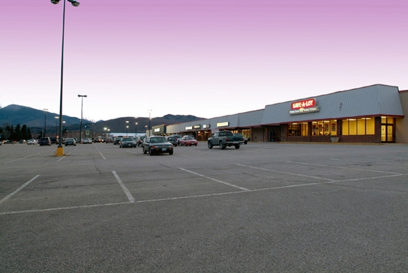
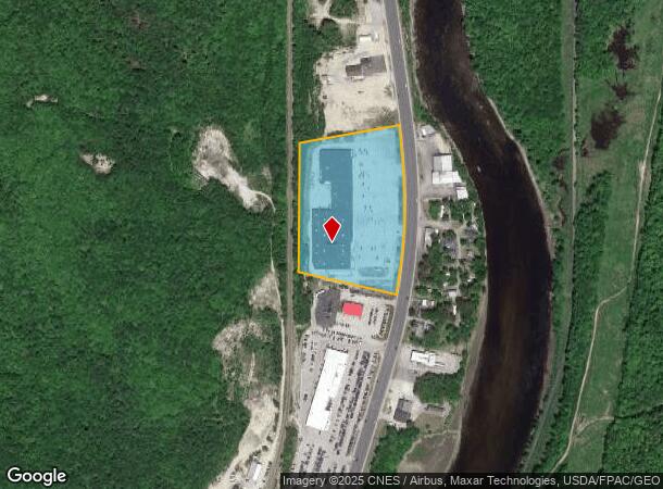
Property Record
491 Main St, Gorham, NH 03581
NEARBY LISTINGS FOR SALE OR LEASE
Property Detail
491 Main St
GORH-000011-000000-000001-U000000
Coos
Regionalshoppingcenterormallwithanchorstore
New Hampshire
X
1
33007C0987D
9.70 AC
2024
Concord/New Hampshire North Area
2024
Other Market Areas
950900
Berlin, NH-VT
74,768 SF
DEMOGRAPHICS near 491 Main St
1 Mile
3 Mile
5 Mile
2024 Total Population
154
2,626
10,200
2029 Population
154
2,615
10,156
Pop Growth 2024-2029
0.00%
(0.42%)
(0.43%)
Average Age
46
47
45
2024 Total Households
72
1,230
4,637
HH Growth 2024-2029
0.00%
(0.49%)
(0.47%)
Median Household Inc
$67,500
$60,481
$45,524
Avg Household Size
2.10
2.10
2.10
2024 Avg HH Vehicles
2.00
2.00
2.00
Median Home Value
$159,615
$166,399
$118,260
Median Year Built
1963
1962
1948
Nearby Places
- Restaurants
- Banks
- Shops
- Fitness
- Groceries
SALE & LEASE HISTORY
LISTING DATE
SALE/LEASE

Sep 25, 2016
For Lease
Nearby Properties
Address
Land Use
TOTAL SIZE
Lot Size
Zoning
Address
Land Use
TOTAL SIZE
Lot Size
Zoning
156,185 SF
15.92 AC
CB
Address
Land Use
TOTAL SIZE
Lot Size
Zoning
0.92 AC
CB
Address
Land Use
TOTAL SIZE
Lot Size
Zoning
Address
Land Use
TOTAL SIZE
Lot Size
Zoning
1,332 SF
6.07 AC
IB
Address
Land Use
TOTAL SIZE
Lot Size
Zoning
2,295.68 AC
M-USEM
Address
Land Use
TOTAL SIZE
Lot Size
Zoning
6,573 SF
3.90 AC
CA
Address
Land Use
TOTAL SIZE
Lot Size
Zoning
61,081 SF
2.90 AC
CA
Address
Land Use
TOTAL SIZE
Lot Size
Zoning
940 AC
RES-A
Address
Land Use
TOTAL SIZE
Lot Size
Zoning
23 AC
IND
Address
Land Use
TOTAL SIZE
Lot Size
Zoning
51,736 SF
5.73 AC
CB
Address
Land Use
TOTAL SIZE
Lot Size
Zoning
5,104 SF
17 AC
RA
Address
Land Use
TOTAL SIZE
Lot Size
Zoning
1,229 SF
M-USEM
Address
Land Use
TOTAL SIZE
Lot Size
Zoning
41,376 SF
4.73 AC
CB
Address
Land Use
TOTAL SIZE
Lot Size
Zoning
6.90 AC
I
Address
Land Use
TOTAL SIZE
Lot Size
Zoning
10,758 SF
1 AC
CA
Address
Land Use
TOTAL SIZE
Lot Size
Zoning
26,356 SF
5.11 AC
CB
Address
Land Use
TOTAL SIZE
Lot Size
Zoning
33,816 SF
8.97 AC
M-USEM
Address
Land Use
TOTAL SIZE
Lot Size
Zoning
41,710 SF
5 AC
CB
Address
Land Use
TOTAL SIZE
Lot Size
Zoning
12,093 SF
0.89 AC
CA
Address
Land Use
TOTAL SIZE
Lot Size
Zoning
15,998 SF
0.19 AC
CA
Address
Land Use
TOTAL SIZE
Lot Size
Zoning
17,185 SF
2.50 AC
CA
Address
Land Use
TOTAL SIZE
Lot Size
Zoning
4,500 SF
3.45 AC
CB
Address
Land Use
TOTAL SIZE
Lot Size
Zoning
1,960 SF
20 AC
RA
Address
Land Use
TOTAL SIZE
Lot Size
Zoning
29,229 SF
9.80 AC
CA
Address
Land Use
TOTAL SIZE
Lot Size
Zoning
2,632 SF
4.25 AC
IND
Address
Land Use
TOTAL SIZE
Lot Size
Zoning
5,000 SF
1.34 AC
RA
Address
Land Use
TOTAL SIZE
Lot Size
Zoning
12,178 SF
1.10 AC
CA
Address
Land Use
TOTAL SIZE
Lot Size
Zoning
7,416 SF
4.88 AC
CB
Address
Land Use
TOTAL SIZE
Lot Size
Zoning
4,896 SF
5.13 AC
CA
The World's #1 Commercial Real Estate Marketplace
Connect with us
© 2025 CoStar Group
The information above has been obtained from sources believed reliable. While we do not doubt its accuracy we have not verified it and make no guarantee, warranty or representation about it. It is your responsibility to independently confirm its accuracy and completeness. Any projections, opinions, assumptions, or estimates used are for example only and do not represent the current or future performance of the property. The value of this transaction to you depends on tax and other factors which should be evaluated by your tax, financial, and legal advisors. You and your advisors should conduct a careful, independent investigation of the property to determine to your satisfaction the suitability of the property for your needs.