Property Record
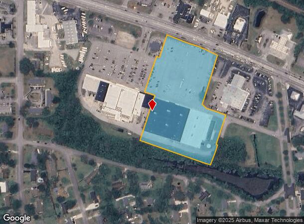
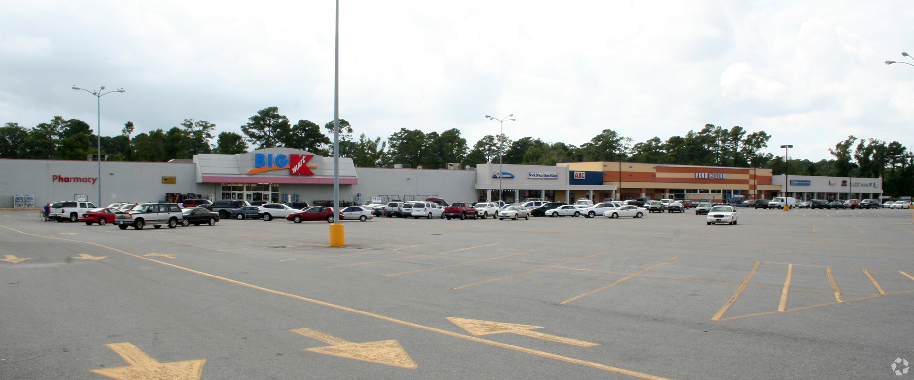
4915 Arendell St, Morehead City, NC 28557

NEARBY LISTINGS FOR SALE OR LEASE
Property Detail
4915 Arendell St
6366.10.45.4123000
AC K-MART MOREHEAD CITY
Wholesaleoutletdiscountstore
Carteret
AE
North Carolina
3720636600J
6.76 AC
2023
Coastal Carolina
2024
Other Market Areas
970606
Morehead City, NC
91,320 SF
DEMOGRAPHICS near 4915 Arendell St
1 Mile
3 Mile
5 Mile
2024 Total Population
2,181
12,371
23,747
2029 Population
2,243
12,950
25,087
Pop Growth 2024-2029
+ 2.84%
+ 4.68%
+ 5.64%
Average Age
49
49
48
2024 Total Households
1,022
5,953
11,134
HH Growth 2024-2029
+ 2.45%
+ 4.50%
+ 5.69%
Median Household Inc
$64,047
$64,189
$64,169
Avg Household Size
2.00
2.00
2.10
2024 Avg HH Vehicles
2.00
2.00
2.00
Median Home Value
$363,763
$311,126
$318,999
Median Year Built
1983
1987
1985
Nearby Places
- Restaurants
- Banks
- Shops
- Fitness
- Groceries
PUBLIC TRANSPORTATION
AIRPORT
Coastal Carolina Regional
DRIVE
WALK
Distance
Coastal Carolina Regional
54 min
33.5 mi
Freight Ports
Port of Morehead City
DRIVE
WALK
Distance
Port of Morehead City
10 min
5.1 mi
Nearby Properties
Address
Land Use
TOTAL SIZE
Lot Size
Zoning
Address
Land Use
TOTAL SIZE
Lot Size
Zoning
4,744 SF
24.01 AC
Address
Land Use
TOTAL SIZE
Lot Size
Zoning
20,886 SF
8.01 AC
Address
Land Use
TOTAL SIZE
Lot Size
Zoning
220,405 SF
25.74 AC
Address
Land Use
TOTAL SIZE
Lot Size
Zoning
41,661 SF
14.90 AC
Address
Land Use
TOTAL SIZE
Lot Size
Zoning
99,630 SF
17.63 AC
Address
Land Use
TOTAL SIZE
Lot Size
Zoning
4,036 SF
29.97 AC
Address
Land Use
TOTAL SIZE
Lot Size
Zoning
161,597 SF
13.30 AC
Address
Land Use
TOTAL SIZE
Lot Size
Zoning
117,000 SF
30.58 AC
Address
Land Use
TOTAL SIZE
Lot Size
Zoning
77,856 SF
49.10 AC
Address
Land Use
TOTAL SIZE
Lot Size
Zoning
72,380 SF
8.22 AC
Address
Land Use
TOTAL SIZE
Lot Size
Zoning
17,873 SF
5.45 AC
Address
Land Use
TOTAL SIZE
Lot Size
Zoning
141,313 SF
18.64 AC
Address
Land Use
TOTAL SIZE
Lot Size
Zoning
53,819 SF
7 AC
Address
Land Use
TOTAL SIZE
Lot Size
Zoning
15,324 SF
2.71 AC
Address
Land Use
TOTAL SIZE
Lot Size
Zoning
52,962 SF
5.02 AC
Address
Land Use
TOTAL SIZE
Lot Size
Zoning
14,868 SF
4.80 AC
Address
Land Use
TOTAL SIZE
Lot Size
Zoning
56,694 SF
7.29 AC
Address
Land Use
TOTAL SIZE
Lot Size
Zoning
17,896 SF
3.10 AC
Address
Land Use
TOTAL SIZE
Lot Size
Zoning
21,945 SF
3.53 AC
Address
Land Use
TOTAL SIZE
Lot Size
Zoning
9,668 SF
156.38 AC
Address
Land Use
TOTAL SIZE
Lot Size
Zoning
10,773 SF
10.01 AC
Address
Land Use
TOTAL SIZE
Lot Size
Zoning
1,980 SF
16.76 AC
Address
Land Use
TOTAL SIZE
Lot Size
Zoning
9,611 SF
3.93 AC
Address
Land Use
TOTAL SIZE
Lot Size
Zoning
15,001 SF
1.70 AC
Address
Land Use
TOTAL SIZE
Lot Size
Zoning
5,068 SF
2.13 AC
Address
Land Use
TOTAL SIZE
Lot Size
Zoning
Address
Land Use
TOTAL SIZE
Lot Size
Zoning
21,850 SF
4.08 AC
The World's #1 Commercial Real Estate Marketplace
Connect with us
© 2025 CoStar Group
The information above has been obtained from sources believed reliable. While we do not doubt its accuracy we have not verified it and make no guarantee, warranty or representation about it. It is your responsibility to independently confirm its accuracy and completeness. Any projections, opinions, assumptions, or estimates used are for example only and do not represent the current or future performance of the property. The value of this transaction to you depends on tax and other factors which should be evaluated by your tax, financial, and legal advisors. You and your advisors should conduct a careful, independent investigation of the property to determine to your satisfaction the suitability of the property for your needs.